|
Much folly has been made towards those who speak about the eventual restrictive and regulatory control over private lands, or that corridors will lead to regulated land use. Here is the validation that this is the Yellowstone to Yukon agenda.
"Using appropriate techniques, computer habitat suitability model results can be an effective first step to identify core and connectivity habitats in order to direct land development, highway construction, and mitigation so that wildlife are protected as they move across the landscape to meet their daily, seasonal, and lifetime needs." "Areas which are identified as core and connectivity habitat, are the focus of restrictive management practices on public lands, and are the focus of land acquisition and conservation easements on private lands." Targhee Pass is an identified area with connectivity habitat, the Elk. Once they gain this objective with overpasses, a migratory Elk corridor designation will follow, and regulatory land use requirements over that area will be pursued for implementation, including all private land in and adjacent to that corridor. The facts are in their own words.
0 Comments
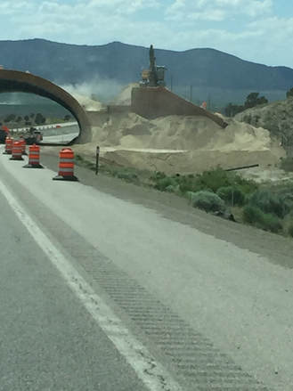
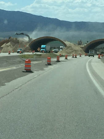
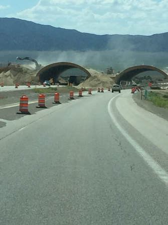
This is wildlife overpass construction East of Wells, Nevada. Note the environmental destruction that it takes to create these monstrosities. Also, these particular overpasses are being built in a barren, flat, uninhabited area unlike the Targhee Pass terrain that does have residential areas and businesses. Picture in your mind how much of Targhee Pass would be destroyed forever with this type of land destruction. How would this construction affect the wetlands in the area? Is that what you want? Road Trip A couple of weeks ago Patsy and I took a long (3000 miles) road trip to Denver, Colorado and then to San Ramon, California. Much of the drive was on Interstate 80. East of Wells, Nevada we encountered three wildlife overpasses and miles of tall mesh fencing. All of these crossed Interstate 80 and were in the middle of nowhere in the high desert. There were no homes in the area. The first was in a very large sage brush covered valley and was very noticeable because there was nothing else there. The second was just a few miles away in a rock canyon. This overpass certainly disturbed the view scape. The third was also just a few miles from the first and second overpasses. It was under construction. The pre-stressed concrete arches had already been placed and there was a large track hoe on the side of it moving soil around. This was causing allot of blowing dust and dirt. The wind blows in Nevada. However, the thing that stuck me most was the large staging area at each end of the overpass. These areas were being used by heavy equipment. Dump trucks were delivering soil to each end of the overpass. The natural environment was totally destroyed for well over 100 feet on each side. There were no wet lands in the area that could be destroyed or a creek that could be damaged with sediment. This is not the case at Targhee Pass on US 20 in Island Park. The potential for damage is very great, especially with heavy rains like we have encounter on the past few weeks. It could be an environmental disaster. We encounter the last three overpasses, on the return trip, North of Wells on US 93. Again, they were in the middle of nowhere, a few miles apart, no homes present in the area, and miles of tall, mesh, wildlife fencing. Part of this area gave me an appreciation for Joe Sielinsky’s comments about the wildlife fencing in the Banff area of Canada. Where the tall fencing was close to the road, you felt like you were in prison. I hated it. It was very confining and not welcoming. There are probably appropriate locations for wildlife overpasses, but US 20 in Island Park is not one of them. The people of Island Park should fight the desecration on our beautiful and inviting recreation area. Island Park is not a high desert, in the middle of nowhere, with no homes present. Quite the contrary. Ken Watts Reprinted with permission from the IP News June 28, 2018 issue
On June 26, 2018, the Subcommittee on the Interior, Energy, and Environment held a hearing on Access to Public Lands: The Effects of Forest Service Road Closures. The purpose was "To examine how Forest Service policies affect access to public lands, as well as the impacts of road closures on nearby communities." They were also investigating "The trend towards road closures and restricting access to Forest Service lands impacts local governments, small-town economies, and the way of life for many Americans who live near Forest Service land." This hearing was a direct attack on the environmentalist agenda to restrict and ban all access to public land via corridors, conservation easements, OHV trail closures, and other means all leading to the death of forests. The USFS requirement for Coordination with local governments, and the failure to follow this federal requirement was also discussed. This video is over an hour but gives a factual account of how environmentalists, NGOs, and conservation initiatives such as Yellowstone to Yukon are massively contributing to the destruction of our forests.
Kim Trotter, Yellowstone to Yukon (Y2Y) Program Director, recently announced the hiring of two new employees for the purposes of advancing the Y2Y agenda in Montana and Idaho. Nick Clarke was hired as the High Divide Project Coordinator. His duties will include:
This is the exact same agenda they pushed for in Island Park. Wildlife overpasses are the ruse for wildlife corridors, and connectivity to other protected areas. The map below covers the area Clarke has been assigned to, the High Divide Salmon-Selway-Bitterroot area. Residents in Salmon, Challis, McCall, Riggins, and Grangeville need to be ready, especially Salmon and Challis. 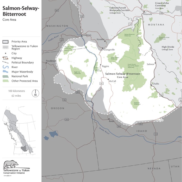 The second hire, Jessie Grossman, will be the Cabinet Purcell Mountain Corridor Project Coordinator. Her coverage area can be seen in the map below. 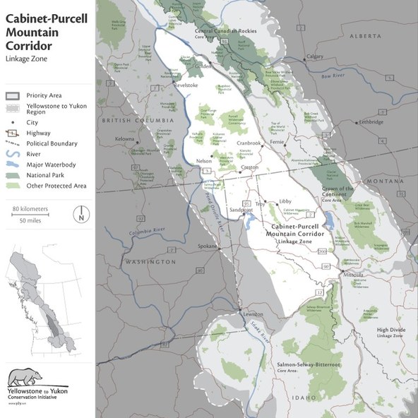 Ms. Grossman's duties will be the same as Clarke, using the bear as the excuse for connectivity. One huge threat of this agenda is the trans-boundary aspect, fully ignoring the Canadian-US border. Y2Y wants bears and other wildlife to have freedom to "roam" wherever it wants between countries, and remove whatever they think are barriers such as people, development, roads, private property, and land use. "Connecting" the Cabinet-Purcell mountains is the Y2Y objective, not understanding that this land and wildlife are already connected. The folks in Bonners Ferry, Sandpoint, and Ponderay need to be alert to this agenda coming their way.
For both areas, look for transportation projects that propose incorporation of wildlife overpasses, out of the blue "new" local groups that support overpasses, more aggressive pushes for placing land into conservation easements, and public meetings and outreach that intend to influence your thinking that overpasses are the only solution. Don't be afraid to confront them with the real agenda, the truth behind overpasses which is corridor designation and connectivity agendas. Alert your neighbors to the same and educate them. Do not let Y2Y implement their agenda in your area. Our friends just north of Idaho in Alberta, Canada are fighting off the same Yellowstone 2 Yukon (Y2Y agendas. Perhaps more frustrating for them is that Y2Y funding in Canada is provided by U.S. foundations and corporations! 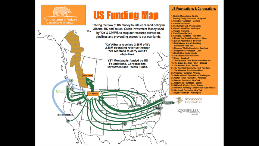 Just as the Brainerd and Wilburforce foundations fund Y2Y activities here, they also fund the same in Canada, along with the Idaho Wolverine Foundation. Fortunately Canadians who are in the fight the same as us understand that we are against this as well. The Cabinet-Purcell mountains are the transborder target between our countries. Y2Y would love to see our border erased, our land just designated as a place where all wildlife can roam freely while forbidding our use and ability to live in those areas. No respect for sovereignty. This is another atrocious aspect to Y2Y.
|
Archives
May 2023
Categories
All
|
 RSS Feed

