|
The Center for Large Landscape Conservation (CLLC) held an event in July 23, titled Saving America's Biodiversity and the Wildlife Corridors Conservation Act, and included several non-governmental organizations (NGO) and congressmen. Honorary hosts included Sen. Tom Udall, Rep. Don Beyer, and Rep. Vern Buchanan. If there was ever any proof needed to substantiate our government is in the pocket of environmentalists, this is it. 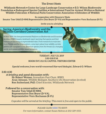 A briefing and panel discussion was held first, followed by a "conservation" with the Honorary hosts, which was filmed and made available on Facebook at this link.
The conversation was about the introduction of the Wildlife Corridors Conservation Act. Interestingly, Rep. Buchanan, a co-sponsor of the bill, was introduced as being "...one of Congress's strongest champions for animals both in the US and overseas". Should an elected official represent animals, constituents, or other countries? Rep. Udall mentioned that because of Tribes, organizations, and the United Nations (UN) we know we are in a crisis, with the UN saying we are about to lose one millions species, needing more corridors, and because of humans spreading around, need to protect half the earth. As a "collaborative, science based approach", this bill completely leaves out the law and jurisdictional authority. The proper explanation of the bill was given, it gives the federal government authority to designate corridors on "federal land", federal land only. But the eventual goal will be encroachment upon state and private lands, through "aggressive" pursuits by "organizations", meaning NGOs. Working at a regional level, this bill would also create a "connectivity data base" used to make "wildlife connectivity decisions". Nothing like mowing over jurisdictions and property rights. Rep. Beyer addressed how Tribal, state, and private land owners can benefit from the bill, and claimed it wasn't about regulations or unfunded mandates, but rather creating "pools of money at the federal level that state and local governments...who understand where their corridors are at...with...local non-profits to put things where they should be". He also believes we have a "responsibility" to give habitat back to animals. Rep. Buchanan spoke to the efficiency of Congress and getting things done. So bipartisanship exists for animal issues but not other more critical issues such as the national debt, budget, immigration, and take over of the health care industry? He stated his focus is "getting a lot of things done for animals". The moderator referred to E.O. Wilson, who stated the bill provides "...the most important step in...enlarging the nations protected areas...'. Rep. Beyer gave a plug to Wilson's book, Half Earth. This is what this bill is really about, expanding protected, non-use land over half of the earth. He also bragged about starting an "International Conservation Caucus" years ago. Should he be paying more attention to his responsibilities to the United States instead of being "engaged with the world, not just the United States" on conservation? Mr. Beyer also applauded the restoration of Grizzlies and that one can tell if an area is "really wild" quoting Ed Abbey that "It's not wilderness unless there are animals out there that can kill you or eat you". What a horrifically insensitive statement, especially to those who have been maimed or killed by wildlife. Rep. Buchanan at least recognized the danger by citing injuries and deaths from animals but inappropriately attributed it to lack of corridors. Does he not realize that wildlife already have their own paths they follow, their own natural corridors they follow, that are not man made? His claim of an $8 billion dollar loss without corridors sounds pretty exaggerated. Sen. Udall opened pandora's box when he started discussing the need for states to become involved in this supposedly federal only bill, as corridors cross jurisdictional boundaries, and then moved to the "most local level of government". This isn't a federal issue, it is an issue of justifying the taking of land across jurisdictional boundaries for the sake of creating corridors, which already exist. Wildlife doesn't know it crosses boundaries, leave it alone, don't make it a man made corridor, and let state and local jurisdictions manage their land where wildlife cross. He openly admits this bill "empowers" the federal government to "work with all the other actors". Mr. Udall, elected representatives are not actors. Rep. Beyer then expounded upon the beauty of the wolf and needing corridors to increase their numbers. Sen. Udall also admitted that this is nothing more than an effort to "make corridors". All three are die hard climate change believers, and they are going to partly fix it with corridors. Oddly, Sen. Udall sees animals as part of our community and should be treated as such. No Mr. Udall, animals are wild, not humans. There was also a brief discussion about how border structures interfere with wildlife movement between countries. This is the mindset of elected officials, working with other countries, ignoring constituents, and devising ways to take land from states and property owners. If this bill passes, which it most likely won't in spite of their confidence it will, it will be advancing the agenda of NGOs and government.
0 Comments
Non-governmental organizations (NGO) are celebrating the introduction of legislation for the "protection and restoration of certain native fish, wildlife, and plant species" on federal land called the Wildlife Corridors Conservation Act. Rep. Donald Beyer tried this before in 2016 and according to Govtrak this new bill only has a 3% chance of passing. The urgency came again following a 2018 United Nations report over mass extinction hysteria. Even though intended for federal land, the caveat includes funding conservation efforts on state and private land that encourages wildlife movement and creating a council to identify priority areas on "non-federal" lands. We all know that "council" would be NGO individuals. Some states, such as Oregon, have passed corridor legislation, others are studying it. While NGOs hammer the federal government for this type of legislation, they are also targeting state legislators for integration of corridors and connectivity policies into state legislation. Idaho has an action plan as well, identifying areas throughout the state for corridors. But the true plans are laid out by the Craighead Institute, targeting land use plans such as comprehensive plans, local zoning and ordinances, even HOAs for inclusions of such conservation drivel. The Western Landowners Alliance, based in New Mexico, has similar goals, advancing policies for connected landscapes. Executive Director, Lesli Allison, has started the campaign for convincing private land owners to conserve their "working lands" for migration. Translated it means designed, regulated, and restricted use. Ms. Allison presented this powerpoint, called Intermingled Public and Private Lands, to the Western Governors Association (WGA) last year, describing her intentions with graphics. Below is the most striking graphic. As the graphic shows, the true agenda behind any corridor type is restricted and highly regulated use on all property types. 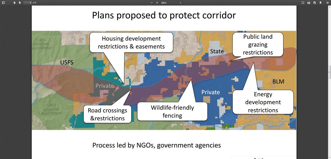 The "threats" Ms. Allison identifies in her powerpoint include development, roads, fences, livestock, and energy. Apparently she also thinks land owners are a threat as the process is "led by NGOs, government agencies". So much for her notion of working with private landowners on working lands. Ms. Allison isn't the only one looking at this "working lands" issue, the WGA held a "working lands" roundtable in April this year that included the Nature Conservancy and Bureau of Land Management, but no citizens. In spite of claims that landowners should be involved in the decisions, and listened to, it is really about deceiving them on the true agenda. The graphic shows the true intention. If a corridor is declared on public land, the committed effort will then be plowing through private, municipal, and state land, extending the corridor from one protected area to another. Corridors, no matter what type, will have protections placed on them for banned or restricted use. As seen in the graphic, the purple shows how corridors provide "connectivity" between protected public land. WARNING: It is critical that citizens fight any reference to corridors in local land use plans such as comprehensive plans, zoning, and ordinances. If inserted, that language will be a stepping stone for this land use restriction agenda. When it is time for comprehensive plan updates, be actively involved so this does not happen. Also, share this with your elected officials and private property owners with working lands so they understand what is happening. Lastly, where is all of this coming from? Gary Tabor, Center for Large Landscape Conservation (CLLC) president, and Network for Landscape Conservation (NLC) Coordinating Committee member, is also the Specialist Group Leader for the International Union for Conservation of Nature (IUCN) Connectivity Conservation program, the purpose of which is to facilitate species conservation through protected areas. CLLC is also an IUCN member, just type in CLLC. Tabor is bringing IUCN ideology to a local level, through the NLC partnerships that include federal agencies, and it is generally understood that IUCN is a UN partner. Hello Agenda 2030. Since information seems to mysteriously disappear off the internet once exposed, here is a copy of the powerpoint. While Yellowstone to Yukon (Y2Y) would like everyone to think the world will end if migratory corridors are not established, and money is being spent to chase down "ungulates" for the purposes of putting GPS collars on them. the truth is they are creating corridors, not identifying them. Jody Hilty, Y2Y President and Chief Scientist, is making money off this scam with two books she wrote with others, called Corridor Ecology. In this Conservation Corridor summary it states the book contains, "Evidence that supports the use of corridors as a conservation strategy...", and explains "...the multitude of approaches and tie the modeling process into the overall process of designing corridors." And finally, "...we provide guiding principles as well as opportunities and challenges to implementing corridors...". They aren't trying to find out where wildlife migrate, they are creating corridors for their large landscape design and land takeover. Even a review on Amazon states, ""The great value of this book lies in the varied examples and in the models, which show the problems and conditions of corridor establishment and the factors related to designing a corridor. The book will inspire the creation of corridors, and explains how to design one and how to take greater advantage of it." Since these corridors are for the purposes of conservation, what does that mean? The definition of conservation is "a careful preservation and protection of something especially, planned management of a natural resource to prevent exploitation, destruction, or neglect." No matter how they frame it, the bottom line intent for corridors is no use of the area. That is what corridors are really about, it has nothing to do with wildlife being fragmented. Y2Y is also a member of the International Union for Conservation of Nature (IUCN). This IUCN booklet, Linkages in the Landscape, The Role of Corridors and Connectivity in Wildlife Conservation, outlines how land should be configured or designed for corridors. This is one model Y2Y is using as an IUCN member. IUCN also has a global policy for their objectives.  Never let Y2Y try and convince you they are not part of this agenda. It is all fact.
Much folly has been made towards those who speak about the eventual restrictive and regulatory control over private lands, or that corridors will lead to regulated land use. Here is the validation that this is the Yellowstone to Yukon agenda.
"Using appropriate techniques, computer habitat suitability model results can be an effective first step to identify core and connectivity habitats in order to direct land development, highway construction, and mitigation so that wildlife are protected as they move across the landscape to meet their daily, seasonal, and lifetime needs." "Areas which are identified as core and connectivity habitat, are the focus of restrictive management practices on public lands, and are the focus of land acquisition and conservation easements on private lands." Targhee Pass is an identified area with connectivity habitat, the Elk. Once they gain this objective with overpasses, a migratory Elk corridor designation will follow, and regulatory land use requirements over that area will be pursued for implementation, including all private land in and adjacent to that corridor. The facts are in their own words. This is the second of a six part series. The reader is highly encouraged to go to these websites and study what is discussed in these articles in order to make an informed decision. Coined in 1935, ecosystem is defined as "a system, or a group of interconnected elements, formed by the interaction of a community of organisms with their environment." Ecosystems have different components of growing, living species. One component is biodiversity. It is defined as "diversity among and within plant and animal species in an environment." Island Park has a multitude of different species which we all love such as wild strawberries, morels, watercress, trees, rainbows, brookies, skunks, porcupines, and the beloved moose and elk. From all indications, each continues to survive in Island Park. Wetlands are "land that has a wet and spongy soil, as a marsh, swamp, or bog." Island Park has the most beautiful marsh behind Elk Creek. In spite of weekly horseback riding through that marsh there was no long term damage. The marsh still exists. Riparian refers to the bank of a river or lake and anything living around it such as fish, other water species, and vegetation. Elk and other animal species use it for water and food. We use it to cast a fly for fish that might take a bite or jumping in for a swim, or maybe just look for a pretty rock. Wildlife, biodiversity, wetlands, and riparian areas are just a few ecosystem components. They are interconnected, dependent on each other for survival, and terms used by NGOs and government agencies to justify their work. Humans are one component not always mentioned. Not seen as a necessary presence in the ecosystem, humans are more often than not considered a destructive force, requiring removal for ecosystem protection. Conservation and removing all human activity are scientists and NGO goals. There is grave concern that land development is encroaching upon buffer zones, areas that surround a protected area which are intended to shield the core area from man’s activities, thus allowing more space for mammals. Private land ownership is in a precarious position. There are ongoing discussions about controlling land use planning from regional to municipal levels. Seen as part of "ecosystem management", land use planning objectives include conservation, stopping development, zoning and growth controls, and increasing restrictions. How you design your home and land will be dictated to you. This article by ScienceDirect explains it beautifully. Land, plant, and animal species don't understand boundaries, extending themselves across states, into designated parks such as West Yellowstone, and even across countries. Ecosystems are viewed in the same manner, there are no jurisdictional boundaries. NGOs such as The Nature Conservancy (TNC), believe these ecosystems, components and corridors, have the right to protection regardless of jurisdictional boundaries. These boundary erasures create a regional concept, erasing boundaries between states and counties, the United States and other countries, and create an artificial "conservation boundary". Essentially, the United States is being divided up into regions with artificial boundaries made up of different conservation areas. Here is a map of "conservation planning boundaries" from the Wildlands Network, which includes the current agenda in Island Park, Yellowstone to Yukon and Crown of the Continent. 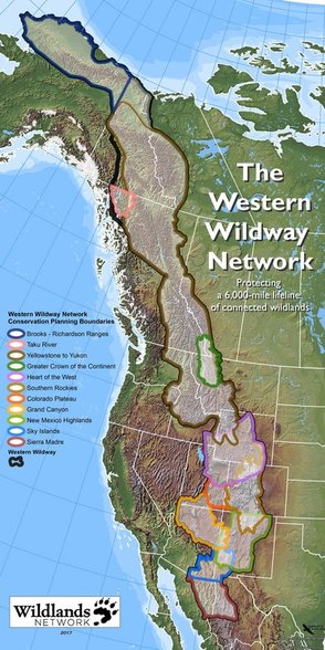 Part of the proposed US 20 IP Corridor Plan is the placement of artificial overpasses for safer passage during Elk migration, just a first step towards creating artificial corridors for connectivity. Each ecosystem component will be gradually introduced for protection, such as riparian areas. Riparian areas extend into surrounding wetlands and other water sources which will extend boundaries further for conservation. Ecosystem components will eventually be used to place the whole environment into some type of corridor needing protection, either through conservation or designation as a protected site. Remember, your private property will be impacted by this.
All of this falls under the Climate change umbrella. According to NGOs drastic action must be taken to not only conserve areas and protect them from humans, "mitigation" measures must be undertaken to prevent loss from development and climate change. The essence of mitigation is to avoid, minimize, and offset environmental impacts to lands and waters. In 2016 the US Fish and Wildlife Service released their new Mitigation Policy. This policy provides a framework and landscape-scale approach for mitigation with increasing conservation, no net loss of resources or values, and effective linkage for landscape scale conservation strategies. Created by the United Nations Environment Program (UNEP), the International Panel on Climate Change (IPCC) always uses science endorsing climate change. However, there is science that does not support the idea of climate change, or even if it exists. According to the International Climate Science Coalition (ICSC) there are opposing scientific views. Even the former Director of Greenpeace, Dr. Patrick Moore, now has doubts. As ecological engineers, scientists believe in giving "point value" to everything, a mathematical formula. Although the NGO conservation agenda has not yet advanced to creating corridors for other components, the same value points will be assigned to them. An example of this can be found in the Cramer Safety Solutions report used in the US 20 IP Corridor Plan, starting on page 159. For some reason land ownership and recreation receive low point value. The environment is remarkably skilled at regenerating itself. Our only job is using it and helping it when needed, like cleaning up the floor bed to reduce fuel loads. It is interesting that such a dichotomy exists with NGOs. On one hand their agenda is leaving the environment in its natural state. At the same time they are creating environmental engineering schemes to alter it. This is a systematic agenda to alter where and how we live, and erase sovereign boundaries. It is part of a broader agenda to destroy state sovereignty and our foundation of government upon which America was built. To all those NGOs and scientists, we have been, and still are, the custodian, guardian, and protector of Idaho and her gifts, way before you were born or formed into little special interest groups, this was not invented by you, and we care for it more responsibly. There has been no long term damage to Idaho from those who have lived here for generations, there is nothing broke that needs fixed. The most comprehensive and destructive land polices were only born when NGOs became involved. Ask any rancher or farmer, they know. The true agenda is pushing us off our land into cities, taking control of our resources, and dictating how, if at all, we can use what is rightfully ours. Idaho is our heritage, our ancestry, we are a native and indigenous people, and we will defend her. There is no bond between you and Idaho. Part 3 will discuss corridors. This is the third of a six part series. The reader is strongly urged to visit these websites and study what is discussed in these articles in order to make an informed decision. Part one covered data collection in the Comprehensive Wildlife Conservation Strategy (CWCS) which was used to create the State Wildlife Action Plan (SWAP) for species and habitat protection. In part two ecosystems and its components were covered These topics create the foundation for corridors and connectivity. Varying greatly in size, shape, and composition, corridors can be described as routes or land tracts used by migrating animals, land designated for specific purpose such as highways like the US 20 Corridor, or they connect "fragmented" patches of habitat. Corridors are seen as a way to increase connectivity, such as transportation or between patches of fragmentation supposedly caused by humans due to different types of land development. Scientists often call this the "anthropogenic" effect, meaning fragmentation is the result of human influence on nature, which NGOs and scientists describe as disruption and "barriers" for plants and animals to survive. They believe corridors, especially protected corridors, provide an unbroken path of suitable habitat and safe passage, if it weren't for humans disrupting it, and connectivity. Three types of corridors follow. Biodiversity corridors are areas of vegetation that allow animals to travel from one patch to another, providing shelter and food for different species. Blaming anthropegenic activity, scientists believe that all species become isolated and unable to migrate as intended because of human "barriers". Elk don't care if they cross your property to get where they are going, they and other grand creatures do it all the time. The agenda underway is identifying biodiversity corridors for conservation to restrict or mandate a full ban on all "anthropogenic" activity, thus ensuring species movement between patches, which already exists now. Island Park residents know differently, we have co-existed with all animal species and their movement from before the time of my father. Wildlife corridors are tracts of land allowing wildlife to migrate for food, shelter, and mating between habitats with migratory paths as an example. Wildlife use biodiversity corridors during their journey for necessary food and shelter. Elk, moose, and other migratory species in Island Park have migrated along these paths for centuries. Who in Island Park has not watched them on their land as they move through? Riparian corridors have everything to do with water. This includes wetlands, marshes, ponds, streams, creeks, springs and lakes. Water species such as fish and beavers, and plants that thrive in wet environments are all included in these corridors. These corridors naturally intersect with biodiversity and wildlife corridors and are often extended by scientists to include buffers, zones, and land for restricted use. Everything is connected to water. However, scientists believe anthropogentic activity is destroying natural corridors and corridors should be sewn together for connectivity, with no "disruption" or "barriers". NGOs, scientists, and the government want us to believe they have the knowledge and authority to artificially engineer corridors. Sorry, Mother Nature beat you to it, her corridors already exist naturally, scientists are only artificial engineers and will never surpass Mother Nature. It is disheartening to watch scientists attempt to environmentally engineer land and corridors that are already perfect with roads and private land not disrupting migration paths, the paths are still there. In 2008, the Western Governor's Association (WGA) participated in this agenda, signing a memorandum of understanding (MOU) with the DOI, DOE, and Department of Agriculture to "coordinate and identify key wildlife corridors and crucial wildlife habitats for uniform mapping and recommendations on policy options and tools for "preserving those landscapes". Did Governor Otter contact you for your opinion? How about those other governors making decisions for Idaho? While the USDA touts the benefits of corridors, there are also studies that have been conducted on the detrimental effects. Because species are crowded into a artificially designed landscape it is often an invitation for invasive species, whether plant or animal, and increased predator behavior. There is also the belief that fragmentation lowers genetic diversity if one herd can't get to another. Elk have been moved around to different locations by scientists for experimentation on their genetic diversity and divergence (mutation). What impact does this have on Elk and the natural order of the environment which is subject to natural laws, not human? Another aspect to corridors is conservation easements. According to the Kansas Natural Resource Coalition, "Often CE properties are enrolled into programs for introduction of endangered species or development of ‘corridors,’ a initiative itself that can profoundly affect communities, industry and private lands. The introduction of endangered species substantially impacts the productivity of neighboring properties." This is the intention of SWAP, identifying species of greatest concern and habitats needing protection. Something to keep in mind if you are asked about placing your land into a conservation easement. Your property may have already been identified for conservation "value" which might contribute to an effort for corridor conservation. These corridors, and all their components, lie within an ecological boundary known as an ecosystem. Ecosystem can be defined as "a system, or a group of interconnected elements, formed by the interaction of a community of organisms with their environment." Scientists have included Island Park in the Greater Yellowstone Ecosystem (GYE). The GYE boundaries are shown in this map. 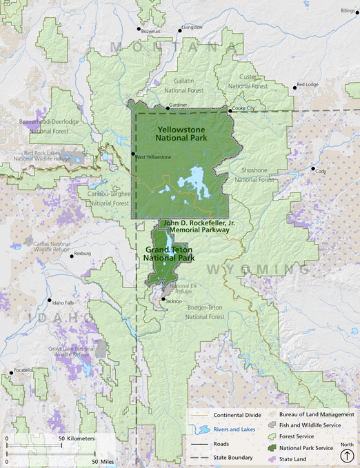 The American Wildlands "Corridors for Life" program from 2007, Center for Large Landscape Conservation (CLLC), Defenders of Wildlife, Wildlife Conservation Society (WCS) with whom the new road ecologist Renee Seidler is connected, and the USFS focus on creating wildlife corridors for connectivity while the North Pacific LCC, Washington State University, and GNLCC focus on riparian connectivity. Using corridors for connectivity is published in their agendas. The scientists who conducted studies in Island Park even admit that wildlife overpasses are needed for connectivity but have not disclosed that to the public. Island Park residents are provided only information about wildlife vehicle collisions to justify the need for wildlife overpasses while the bigger threat, changing the environmental structure, culture, identity, ownership, and heritage of Island Park, is omitted.
Gary Tabor, founder of the Center for Large Landscape Conservation (CLLC) and who mingles with all the local initiatives, worked with Va. Rep Donald Beyer (D) on H.R. 6448 (114th): Wildlife Corridors Conservation Act. Although not enacted in 2016, there are plans to reintroduce it again this year. This bill would create a "National Wildlife Corridors System" which would mean federal law for corridor designation, much like a national monument designation. Island Park residents don't want to be a federally designated anything. Also not welcome, a Virginia representative making decisions that would potentially affect Island Park. The new ITD "road ecologist", Renee Seidler, participated in a migratory study on Pronghorn in Wyoming. While the WCS claims the "U.S. Forest Service established the nation’s first federally designated wildlife corridor" in 2008, the truth is somewhat different. It was not a declaration of the "first" federally designated corridor, it was a forest plan amendment that merely allowed "continued successful pronghorn migration." Amending the "...Bridger-Teton National Forest Land and Resource Management Plan by designating a Pronghorn Migration Corridor...", it added the following standard, “All projects, activities, and infrastructure authorized in the designated Pronghorn Migration Corridor will be designed, timed and/or located to allow continued successful migration of the pronghorn...", while not constraining "...activities on private land..." within the forest boundary. The report also states, "...activities currently authorized by the Forest Service within the corridor coexist with successful migration..." such as grazing, and concluded that no changes were needed for grazing or infrastructure. So, the Bridger-Teton National Forest Supervisor, in a NEPA Environmental Assessment phase, casually gave a name to a section of forestland that already existed, the NGOs then exaggerating it into some grand event which didn't exist. There was no congressional act or official designation, no state declaration, no proclamation, nothing. The BLM is not part of this forest plan amendment. "The amendment just signed does not protect the entire pronghorn migration - it applies only to 45 miles of the migration corridor located on Forest Service lands. The remaining 30 miles of the migration route occur on private lands and areas managed by the Bureau of Land Management, BLM." Seasonal protection of the Pronghorn is provided by the BLM but there is no federally designated Pronghorn corridor as the NGOs would have us believe. Now this exaggerated claim has been stretched to declaring the "Path of the Pronghorn" as the "only federally-designated wildlife migration corridor in the United States". It is misleading and dishonest. Beware, the WCS is watching Craters of the Moon stating Pronghorn are "...restricted by mountains, fences, a highway, and fields of jagged lava from Craters of the Moon National Monument and Preserve...”. How do those Pronghorn migrate every year in spite of these restrictions and natural landscapes? Using the Elk migratory path is just the first step, next will be a demand to protect the biodiversity corridor, then a riparian corridor, any corridor will be used to continue sewing them together for control over the land while describing it as connectivity, and for a "seamless" integration into the GYE. They don't care about the Elk, they are only interested in using them to take land for their agenda. Island Park residents have "connectivity" with their land as those before him, crossing different "corridors" that allow us to remain "connected" to our land. There is no justification for taking what already is a blended and pristine area, breaking it into ecological categories and corridors, violating state and county sovereignty, then creating plans to alter it. This misrepresents the reality that Island Park is already connected, in every way. The only disconnection is the one that is fabricated by scientists, NGOs, and the government. It is their imaginary utopia being imposed on Island Park residents, and those poor Elk. The greater plan by scientists and NGOs is putting Island Park into full conservation status without your consent, creating artificial landscape designs and boundaries, convincing you that corridors aren't connected because a road or your house is in the way, telling you connectivity is needed for integration into an ecosystem where it already exists, and destroying our God given right and legal authority as Fremont County residents to control how land is used. From the Declaration of Independence: It becomes necessary for one people to assume: "...the separate and equal station to which the laws of Nature and of Nature's God entitle them..." "...that they are endowed by their Creator with certain unalienable rights, governments...deriving their just powers from the consent of the governed...". The consent of the governed has not been given for these plans. Part 4 in this series will discuss connectivity, who is involved, and its implications. Connectivity This is the fourth of a six part series. The reader is strongly urged to visit these websites and study what is discussed in these articles in order to make an informed decision. Part one covered data collection in the Comprehensive Wildlife Conservation Strategy (CWCS) which was used to create the State Wildlife Action Plan (SWAP) for species and habitat protection. In part two ecosystems and its components were covered and corridors were explained in part three. Now it is time to put all of it together with connectivity, the true agenda. Here is the map of the boundaries in the Greater Yellowstone Ecosystem (GYE), where the corridors and components lay. 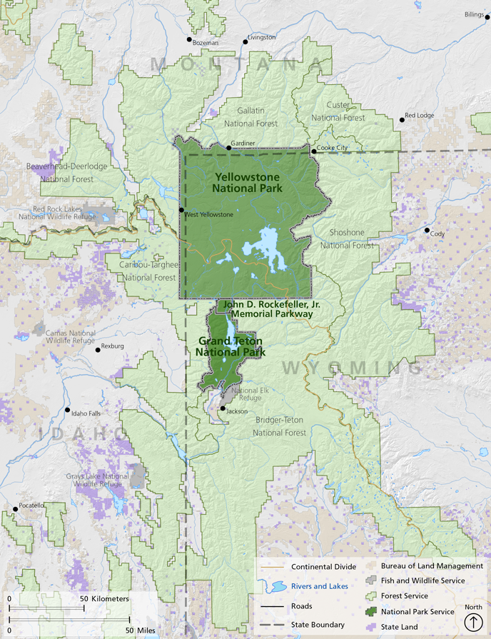 Keeping corridors within the ecosystem boundary is the foundation for connectivity with Island Park as a prime target in the GYE. NGOs and scientists are using the US 20 Corridor and Elk migration to advance connectivity at Targhee Pass. It has nothing to do with saving Elk, the Elk are being used for emotional manipulation and a distraction. Several targeted areas for redesign have now been narrowed down to just the Targhee Pass, only because it is the closest site for connectivity. With the Strategic Wildlife Action Plan (SWAP) identification of Species of Greatest Conservation Need (SGCN) and priority habitat conservation, along with other corridors, the plan has been established for sequential, consecutive, and progressive steps towards connectivity in the GYE, giving wildlife "room to roam". Island Park has a yellow star for high connectivity, this connectivity plan has been in the works for several years, and that is why IP is being targeted. 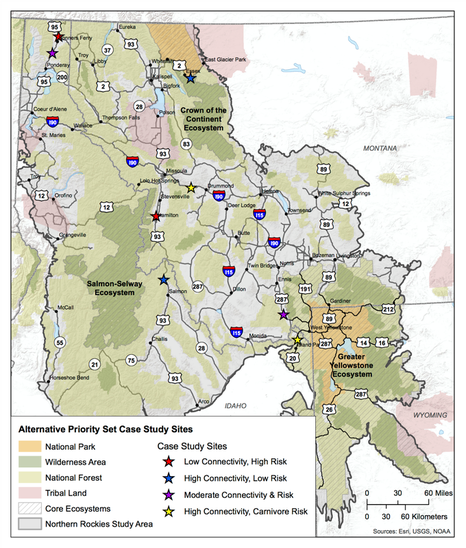 Scientists and NGOs believe connectivity is needed for species population persistence, ensuring that one or many species can move freely throughout the landscape. Because they also believe humans cause connectivity "fragmentation" with land development, a highly aggressive effort is underway to convince land owners to place their land into conservation easements (CE), restrict or ban road use, restrict development and growth boundaries, buy land, and take advantage of road corridors for halting fragmentation. To these groups, connectivity means highly restricted human use to none at all. Corridors and connectivity are the means to control land use. Once land is in their possession, regardless of being a CE, protected or restricted area, or any other designation, control of that land will be dictated by the government, NGOs, and land trust groups. If your county elected officials allow it, these groups will try and convince them to change land use planning in comprehensive plans, forcing you to comply with conservation measures on your property, reduce land use, and dictate or halt how you use your land. The Wildlife Conservation Society (WCS) has already "provided site-specific science in this region to aid Fremont County, Idaho to prepare a comprehensive growth and subdivision plan that considers the importance of protecting biodiversity and wildlife migration corridors." The Northwest Property Owners Alliance (NWPOA) in northern Idaho has already been through it and can tell you what will happen if your county acquiesces. They experienced the same dynamics being used by the US 20 Corridor study team including failure to notify, misinformation, and domination by special interest groups. Their article on environmentalism really captures what Island Park is experiencing. In 2015, after two years of steering committee meetings (including UN NGOs and Canada), the Greater Northern Landscape Cooperative (GNLCC) released a preliminary "Connectivity Pilot Project" report and "...selected connectivity as a priority shared landscape objective...". The second of four objectives was to, "Conserve a permeable landscape with connectivity across aquatic and terrestrial ecosystems, including species movement, genetic connectivity, migration, dispersal, life history, and biophysical processes." The corridors discussed in part three, plus the others listed here will all be used to justify placing Island Park into a massive, large scale, conservation area and eventual integration into the GYE as a protected area, under complete conservation status, with controlled land use. This agenda has been in the works for years, using Elk and the US 20 corridor is just the first step. Their "data basin" is used to "inventory connectivity data"..."identify important areas for action"..."identify potential connectivity opportunities"...with the data also capturing..."'human footprint’ layers"..."land use stressors that may be expected to impact connectivity"..."as well as map layers representing jurisdictional boundaries." Island Park is specifically targeted in this report. Using the High Divide (HD) as their "connection", the short term objective included mitigating US 20 and Hwy 87 corridors and habitat augmentation at highway crossings. Long term objectives included annexing Henry's Fork and Island Park from the Great Basin Landscape Conservation Cooperative (GBLCC) to GNLCC; supporting collaborative work of state and federal agencies, and NGOs to conserve private lands and connect public lands; focusing on landscape water conservation; implementing highway mitigation for key linkages; and creating disincentives for wildlife urban interface (WUI-zone of transition between unoccupied land and human development). Participants in this report included Gary Tabor, Michael Whitfield, Gregg Servheen, and Renee Seidler, the new ITD road ecologist expert for the US 20 Corridor plan. Ms. Seidler has stated her belief in connectivity, her other work is on connectivity, the cooperative agreement between the ITD and IDFG states the job responsibilities included developing programmatic and site specific information and criteria on wildlife connectivity, and her job description states the same. Conveniently, IDFG Wildlife Coordinator, Gregg Servheen, is on the GNLCC Steering Committee mentioned above, and signed the contract between IDFG and ITD for the position Ms. Seidler eventually took through the Wildlife Management Institute (WMI). Mr. Servheen also works on helping you turn your land over for conservation easements (CE) through the Private Landowner Network, or find conservation resources. He worked with the Western Governor's Association (WGA) to build data bases on biological information for preserving wildlife corridors and habitats, and the goal to "complete a connectivity/linkage plan" along the High Divide. While all of this gives the appearance of impropriety, it is nothing more than a self-created, conglomerate of government agencies and NGOs, operating under no legal authority, working without public involvement on plans to address issues they created, disguising it as their concern about wildlife vehicle collisions (WVC), and which will eventually be used as an excuse for wildlife connectivity. WVC are nothing more than a distraction to keep you from learning about the connectivity agenda. A copy of the contract can be downloaded here.
In fact, the ITD and IDFG were so confident the US 20 Corridor project was in the bag, they hired Ms. Seidler by April 17th to move on to the connectivity phase. This was at least 10 days prior to the cancelled April 27th meeting that was supposed to include Island Park residents and their input.  Ms. Seidler is well prepared for this job having previously conducted a study with IDFG in 2014 called: US 20, Island Park Wildlife Collision Study, An examination of Road Ecology in the Island Park Caldera: Elk and Moose Migration Across US Highway 20. The summary states, "Conservation and mitigation efforts for Elk and Moose...will likely have significant positive impacts on habitat connectivity...". A copy of this report can be downloaded here. The GNLCC held a major workshop in 2015, Conservation of Continental Connectivity through Community Based Collaboration. Presenting at this workshop, the High Divide celebrated their increase in CE from 194,483 acres to 1.2 million in 9 years, and their work in connecting large core protected areas and wildlife connectivity. Their goal is Ecological linkage between protected core areas to conserve wide-‐ranging wildlife in response to climate change, not WVC. To them, "Working Across Boundaries" includes "Local expertise—stakeholder input". This has rarely been sought from Island Park, but rather from an assembly of scientists, government officials, and NGOs, few who even have one connection to Island Park. The goal is complete "protected" connectivity in large landscape areas where Island Park sits. GNLCC held a Resource Managers Connectivity workshop in April, 2015, with Ms. Seidler as a participant and Gary Tabor and Michael Whitfield as speakers. Mr. Whitfield was also on the program committee for the 2014 National Workshop on Large Landscape Conservation held in Washington, D.C.. Federal government agencies and NGOs comprised 76% of the participants, with only 1% landowners participating. As the founder of the Center for Large Landscape Conservation (CLLC), Gary Tabor has created both a Connectivity Conservation Hub in partnership with the GNLCC, located in Jackson, and a Ecological Connectivity Project with all the data and maps needed to conserve "a permable (sic) landscape with connectivity across its geography". According to Mr. Tabor, "A corridor is a distinct component of the landscape that provides connectivity. Wildlife corridors specifically facilitate the movement of animals, while other types of corridors may support connectivity for plants or ecological processes." The Ecological Connectivity Project brings "managers" together who focus on connectivity. "The goal of the project is to conserve a permeable landscape with connectivity across aquatic and terrestrial ecosystems, including species movement, genetic connectivity, migration, dispersal, life history, and biophysical processes." Michael Whitfield from the High Divide is also involved. This project does not include any Island Park residents, only government officials, NGOs, and initiative leaders. The justification for this project are primarily based on executive orders, policy resolutions, white papers, secretarial orders, and regulatory decisions that are not found in Idaho or federal law. However, GNLCC funding for 2017 is directed towards supporting this project for water, species, terrestrial and migration connectivity in large landscapes, your tax dollar. 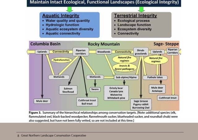 Hidden on a US Geological Survey website is the 2015 proposal, "Landscape Conservation Design in the High Divide" with Mr. Whitfield as the Project Coordinator, and who is also the executive director of the Heart of the Rockies (HOR) initiative. Multiple NGOs, land trusts, and federal and state agencies are involved. The project summary "...seeks support to identify and evaluate future landscape configurations...emphasizing wildlife connectivity between large protected core areas..." such as Yellowstone. The need for "Landscape Conservation Design" was cited as one of the elements of the USFWS Strategic Habitat Conservation Plan. "A conservation design (cluster development) is a type of “Planned Unit Development” in which the underlying zoning and subdivision ordinances are modified to allow buildings (usually residences) to be grouped together on part of the site while permanently protecting the remainder of the site from development." This project supports the GNLCC Strategic Conservation Framework, one goal being to "Conserve a permeable landscape with connectivity across aquatic and terrestrial ecosystems...". All of the data collection will be used to redesign Island Park into some artificial utopian paradise, rather than let her exist as she has for centuries, or be developed through local representation. And with all due respect sir, do not lump residents into a "Human Modification Index. Workshops on this project were supposedly held in Nov 15' through Fed 16', conveniently when most residents were not available. This is how subversive these groups are. A copy of the proposal can be downloaded here. These individuals and groups have been working with each other, making decisions about Island Park and the residents, behind their backs. Do those who live in Island Park want their covert plans?
The following initiatives and organizations are actively involved in the connectivity agenda: Heart of the Rockies (HOR); Yellowstone to Yukon (Y2Y), High Divide (HD), Crown of the Continent (COC), Greater Yellowstone Coalition (GYC), and Future West (FW). "Although America's national parks include some of the wildest places on Earth, no park in the U.S....is large enough to support the full range of native biological diversity over the long-term. In order to accommodate wide-ranging animals...our parks must be connected to other protected areas via wildlife corridors and their boundaries should be expanded wherever possible." (Rewilding Our National Parks) A brief word why so many "experts" are making the decisions. These scientists are actually technocrats, experts in science who have a lot of power in, or influence with the government and are an adherent of technocracy. Technocracy is the power shift from elected representatives and bureaucrats to technocrats (engineers, managers, scientists); management of society by technical experts; or a society that is controlled by scientists, engineers, and other experts. Is this not where we are at? Patrick Wood has a series of excellent videos on his website, Technocracy News and Trends, that provide valuable insight into how our government has transitioned over to these "experts" and away from the people. It is the responsibility of elected officials to listen to those who elected them, not technocrats or special interest groups, or those who are not Fremont county residents. Have we abdicated our inherent power and responsibility of self-governance to others? Or has it been stolen from us? No efforts have been taken to disclose or involve Island Park residents in these plans, no alternatives to overpasses and fencing have been discussed, no input has been sought from anyone except the UN NGOs, cooperatives, technocrats, and government agencies, and No discussion has ever taken place on their plans for connectivity. Studies were conducted for the US 20 Corridor plan without required prior notification to Island Park residents. And why should they bother, the protection of Elk is not the issue, it is a distraction from what they are really planning. All evidence points to the agenda for connectivity, on websites, in reports, participants own statements, and in studies. The ITD, their study team, NGOs, and initiatives have not been transparent with Island Park residents, misrepresented what they are actually doing, and have violated every drop of what is ethical. Shame on all of them. It is important to remember, there is no federal legislation for this agenda. What law allows arbitrary erasure of jurisdictional boundaries? This is a concerted effort by individuals and groups with an ideology, who have successfully engaged the government with the same ideology, and are proceeding forward without any laws. Island Park has a population of 286 as of 2016. That swells to several thousand during the summer when residents come to their summer homes. The number of individuals pursuing this connectivity and conservation agenda are in the thousands, with millions of dollars being funneled into it. Island Park residents, who own homes and pay taxes, are the guardians of Island Park, and who elect city and country officials to represent them. Officials are obligated to listen to their voice, not special interest groups from other states or counties. The technocrats and elite who believe they know better, and who hide their agenda, are usurping those rights. Is this what Fremont County citizens want? The Declaration of Independence states governments derive "...their just powers from the consent of the governed." The Idaho Constitution, Article I, Section 2 states, "All political power is inherent in the people." It is time to recapture the self governance our Founding Fathers created for us. No individual wants Elk harmed and WVC must certainly be addressed. However, tearing up and environmentally engineering the land for ulterior motives is not the solution, there are other alternatives beyond what the technocrats say won't work that require consideration. Island Park residents should be the lead in discussing these alternatives, how they want to protect her and the Elk, and the ones who hold the right to make those decisions. These technocrats and NGOs have zero connection to Island Park, spending their time reducing it to nothing more than a mathematical formula, and assigning point values for the purpose of artificially engineering it into something that it isn't. There is no Island Park asset that has more or less value than another and in spite of what they say or believe, this land is not "fragmented" by us, it is fully connected in every way. They are welcome to visit and walk on the path they designated, but respectfully, do not come to Island Park for environmental engineering, passing it off as a transportation project for saving wildlife when your true goal is connectivity and "conservation design". Island Park is ours to protect, not yours to alter. Part 5 will reveal where all of this originated. |
Archives
May 2023
Categories
All
|
||
 RSS Feed

