|
A forest service plan amendment in fact, just gave a name to a Pronghorn migration path (a path they have drawn/created on a map). The public/private partnerships behind the push for the recognition of a wildlife corridor provided that ’science’. The graphic below belongs to Gary Tabor’s Center for Large Landscape Conservation (CLLC) and by his definition an ‘overlay’ action was added as an amendment to this forest plan identifying the boundaries of an already existing and newly recognized route of the Pronghorn. Special status would then apply to that corridor definition and all activities there would be subject to non-interference to the migratory process. (see italic text in graphic) 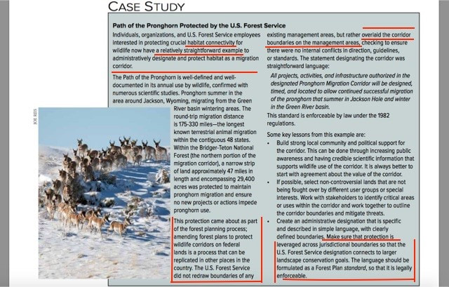 As a relatively new regulatory concept ‘overlay’ to an existing plan rather than a designation that would require congressional approval, the first trial of it's usage by a federal management agency (USFS), in the case of Path of the Pronghorn (POP) was deemed successful by the Center for Large Landscape Conservation (CLLC). According to Gary Tabor, this overlay came with "clearly defined boundaries", crossing jurisdictional boundaries "so that the U.S. Forest Service overlay recognition could connect to larger landscape conservation goals” which can then be legally enforceable. Federal and state wildlife management agencies coordinated in the case of the Wyoming pronghorn. Wyoming state transportation agreed to re-task their own federal funding. A public and private land trust management collaboration was developed along the length of the designated corridor. The concept was unopposed and supported, both locally and by the Wyoming legislature. 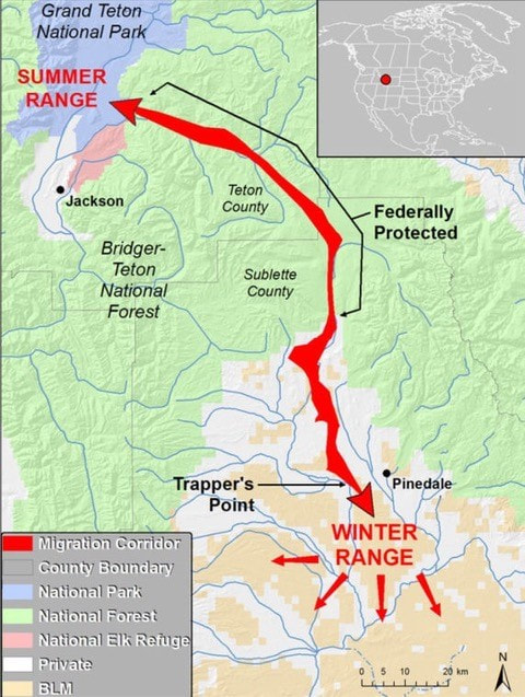 In the following graphic ‘overlay’ as a regulatory tool is explained. As the POP example demonstrates, preserving a ‘sensitive area/wildlife habitat’ as a ‘potential use’ for the tool, was in fact, realistically applied. The forest supervisor determined the amendment met the criteria for a FONSI (findings of no significant impact) when considering the impact on the miles of the corridor on public forest land. The long term goal for overlays are too extend them beyond public land, and link them to adjoining private land. Conservation easements are a handy mechanism to do this. Land trust managers make this coordination possible. All connected together, these lands become linkages between conserved land, achieving the vital ’stepping stones’ for connectivity. 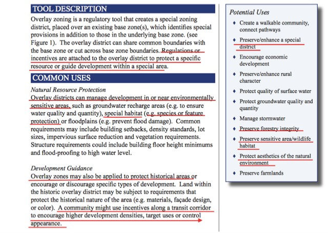 The Wildlife Conservation Society (WCS) was the principal non-governmental organization in making POP a success. Renee Seidler was part of this team and served as the Interpretive Site Leader of the POP project in Wyoming. This project has been applauded by the conservation community as the first of it’s kind, a large wildlife game species migratory and safe passage corridor.
Renee Seidler was hired as an IDFG contractor, for a 3-year term, to incorporate wildlife crossing and connectivity information into environmental assessments; develop data and information on: wildlife roadkill, connectivity, and crossings; focus on reducing wildlife-vehicle collisions (WVC); and facilitating wildlife movement across US 20 north of Ashton, ID. At the July, 2017 ITD workshop she presented information on the concept of safe wildlife overpasses as an alternative for Targhee Pass. At that same workshop, ITD finally revealed that they are considering 3 wildlife overpass structure builds at successive mile post markers at the heart of Targhee Pass. The first just north of Big Horn Hills Estates, the middle structure near Howard Springs, and the final just before the Idaho/Montana state line. It should also be noted that in 2021-22 ITD is proposing a $22 million dollar budget for work at Targhee Pass. Would it be fair to state that Ms. Seidler was hired for the purposes of advancing the same project for Targhee Pass as she helped to make a reality for the POP?
0 Comments
Here is the website for Great Northern Landscape Conservation Cooperative (GNLCC) funding. Specific to the IP area:
Center for Large Landscape Conservation-Gary Tabor: $75,000 for Conserving an Intact and Connected GNLCC Landscape. From 2014 to 2016 Total Funds Allocated $190,000 Heart of the Rockes (HOR)-Michael Whitfield: $75,000 for Landscape Conservation Design in the High Divide. An Analysis of Future Landscape Scenarios and Their Viability. From 2015 to 2016 Total Funds Allocated $150,000. This is your tax dollar paying these initiative leaders to implement their agenda for conservation over you. Also, the Whitfield is on the GNLCC Steering Committee, which has authority over projects. and Tabor is on the GNLCC Advisory Team. Isn't it interesting they have money directed back to their own initiatives? While the Idaho Transportation Department (ITD) claims they have included public input from IP residents, they are clearly more focused on learning more about wildlife overpasses from other states. The Island Park Safe Wildlife Passage Initiative (IPSWPI) was more than happy to advertise this comradery, not only with ITD but with Idaho Fish and Game (IDFG), Wyoming Department of Transportation (WDT), and Wyoming Game & Fish (WGF) as well.  This graphic clearly shows the heavy focus on wildlife overpasses by ITD and IDFG over other alternatives, alternatives that are far more reasonable at Targhee Pass given the geography, historical significance, and wetlands that would be significantly destroyed by three overpasses. The overpass structure they are looking at is in an isolated, flat terrain that does not even remotely reflect the Targhee Pass geography.
ITD and IDFG should be asked why they devote such time to overpasses while not considering as much time discussing other alternatives with IP residents. IP residents are only allowed a three hour meeting every couple of months, where the dominant display is for overpasses, and told to write other alternatives down. Where is the collaborative balance in this? The "Great Northern Landscape Conservation Cooperative (GNLCC) Advisory Team convened for 8 sessions from January to July in 2016 to identify a subset of high level priorities for the GNLCC." Their objective was to "refine upcoming FY17 funding guidance to a set of commonly shared, high priority achievable outcomes with specific objectives and science needs that will guide funding for next 5 years." One goal is connectivity. 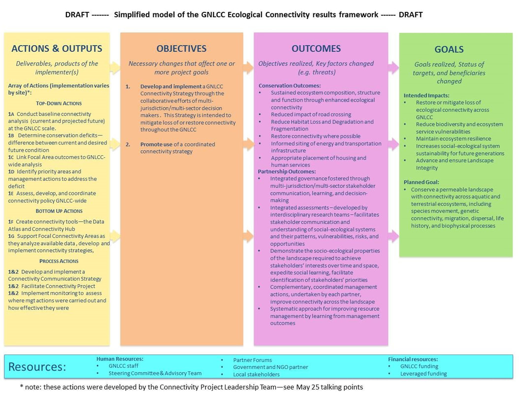 The above graphic outlines what actions they believe are needed to achieve connectivity across the GNLCC. As seen in the Goals box, the "Planned Goal" is "Conserve a permeable landscape with connectivity across aquatic and terrestrial ecosystems, including species movement, genetic connectivity, migration, dispersal, life history, and biophysical processes."
If the wildlife overpasses are successfully integrated into the Targhee Pass transportation proposed project, it will not be an end to the agenda. Efforts will continue to also include all ecosystem elements such as water and habitat. At some point, all land will need "conservation" for some reason or another. Overpasses to corridors to water to habitat. Don't forget that people are in those paths, and as such there will be a requirement for them to follow the conservation regulations established by the individuals and initiatives associated with the GNLCC. Secretary Zinke order revoked all of this activity but there is no sign they are stopping. Wildlife overpass integration into the Targhee Pass transportation project must not happen. The graphic below has since been removed from the Y2Y site. 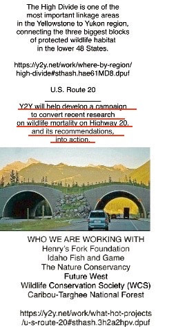 When it was removed is unclear. However, this graphic is significant because it states, "The High Divide is one of the most important linkage areas in the Yellowstone to Yukon region...connecting...protected wildlife habitat...". The scientific definition for linkage is "Connective land intended to promote movement of multiple focal species or propagation of ecosystem processes." As seen by the graphic below, wildlife overpasses can be used as "stepping stones" for connectivity, but even better, a corridor really blankets the land and includes every aspect. 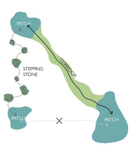 Y2Y is using the High Divide to complete their connectivity agenda. Wildlife overpasses are just a "stepping stone" to accomplish that agenda.
"When People Show You Who They Are...Believe Them" Maya Angelou The new Idaho Transportation Department (ITD) ‘road ecology specialist’ is Renee Seidler. She has lived in Bozeman, MT, Jackson Hole WY, and several other states in the Pacific and Southwest regions. A large body of her work was conducted as a Wildlife Conservation Society (WCS) employee, an international NGO.
This will not be her first time studying Hwy 20. Following a 4 year study, Ms. Seidler co-authored a road ecology report with Tim Cramer from ITD, the Cramer/Seidler Study: US 20 Road Ecology in the Island Park Caldera, 2014. Jon Beckmann (WCS Connectivity Initiative Coordinator) and Shane Roberts, ITD employee, also participated in this study. The former “road ecology resource specialist” was Patricia Cramer from Utah State University. Ms. Cramer authored two studies, one on wildlife vehicle collisions (WVC) for the entire state of Idaho in 2014, and the second on US 20 Safety Solutions in 2016 with District 6 ITD environmental planner Tim Cramer. The Safety Solutions report recommended 17 over and underpass structures throughout the Hwy 20 corridor. Three studies, Cramer, Cramer-Cramer and Cramer-Seidler, all studying the same issue. How many studies do we need on Hwy 20, and at what cost to the Idaho taxpayer? What more is there to study except how overpasses can be utilized for wildlife connectivity, Ms. Seidler’s area of expertise? Renee Seidler and Michael Whitfield, Heart Of The Rockies (HOR) Executive Director, participated in the 2014 Crossing Boundaries: Science, Management & Conservation in the Greater Yellowstone Conference, held at Yellowstone National Park. They gave presentations and discussions on CONNECTIVITY extending out from Yellowstone. In Concurrent session #5b will you find them: 1) The Growing Wildland-Exurban Development Area Interface Michael B. Whitfield - Partnerships and Science to link Yellowstone National Park to protected areas and local communities across the High Divide. 2) Renee Seidler - Identifying impediments to long-distance mammal migrations. 3) and pg. 19…Great Northern Land Conservation Cooperative Network Ms. Seidler is known for her work in the WCS as the Associate Conservationist in the North America Program. She was also the Wildlife Overpass Interpretive Site leader in Pinedale. Her most recent focus of work was largely in the species area of pronghorns. It is most likely that Renee Seidler is an outstanding professional in her field, just as Patricia Cramer is, but her expertise lends itself to a CONNECTIVITY goal and also to wildlife overpass structure solutions within wildlife migration corridors. Is that the proposal the Hwy 20 Study Team is considering? It is difficult to determine given their limited engagement with the IP community. Ms. Seidler is not an independent researcher coming without a pre-determined mind-set or analytical bias. Her addition to the study team is a clear indication that overpass structures are the only solution for Targhee Pass the project team intends to offer. As the Hwy 20 Proposed Project keeps changing, with new faces being introduced, and increasing public concern with questions being expressed about this project, each new step taken by ITD reveals an end goal that becomes more clear, wildlife overpasses. We are watching a process that suggests a pre-determined outcome, involving collaborative associations and consultants with bodies of work that are aligned with the same ideology. Three studies on Hwy 20, all conducted during a similar time frame in Fremont County, lends one to assume…something must be up. All three studies conclude that wildlife overpasses are recommended for wildlife corridor planning towards connectivity. The Wildlife Conservation Society…hmmmm…isn’t that who Renee Seidler works for? Jon Beckmann is her boss and she just completed work in Wyoming on wildlife overpasses. What do you think she brings to the project? The federal and state government agencies are not allowed to engage in private planning, design, policy and decision making activities without the consent and the involvement of The Public that they serve. IP, as a community, has seen the complete absence of full disclosure and honest engagement in the initial planning and study phases which federal and state agencies and their partnering NGOs started here 7 years ago when Ms. Seidler started her first study in 2010. There are delays, restructuring of the process which invites NEPA questions, limited engagement with the public, and significant non-disclosures involving future planning for Hwy 20. Through research many issues have been discovered. UPDATE TO ORIGINAL ARTICLE The second ITD workshop was held in Island Park in July. Renee Seidler had a presentation on the ITD alternatives solutions that evening. She was accompanied by Kim Trotter, National director of Y2Y and the local face of the Island Park Safe Wildlife Passage Initiative which is promoting 3 wildlife overpasses at Targhee Pass. Renee Seidler’s role here no longer needs to be surmised. Her role here is apparent with a IDFG contract for a 3 year term. At the end of 3 years, ITD has projected a budget for 22 million dollars to be spent at Targhee Pass. Renee Seidler’s presentation that night was completely about the wildlife overpass alternative and associated costs. The following article appeared in part in the IP News. It is the shared sentiment of this website and has been copied in part, edited to update information, and is re-published here with author permission. (an opinion article) We have had no VOICE in this. We all know the ITD proposed public engagement schedule has been disrupted, we are still unsure what they intend to offer and when they intend to offer it. One possible worrisome outcome was recently expressed to me. How do we address whatever is coming next, when and if it comes? If we do not want to meet with them at a meeting they have designed, might they say they did an outreach with us but we refused, therefore, they had no choice but to move on. Multiple comments have been submitted to ITD concerning lack of Public Participation in this HWY 20 Corridor Planning Process. Simple question. To date, does anyone know exactly what it is ITD is proposing for The 20 Corridor and Targhee Pass? What is their plan, so far they are pretty quiet about that…but they do have one, and if you research clues can be found. Multiple potential planning activities and prior correspondences between federal and state agencies and their select partnerships have already happened, and have resulted in a plan WE have had NO PART IN. This potential corridor map link below can be found on the ITD HWY 20 Corridor Planning site. It is a support link to ITD’s potential ‘alternative’ solutions. All of the studies conducted up to this point will support it, what are we are going to be asked to participate going forward? There is a lot more than just a potential safe passage structure build at Targhee Pass that is being sought after here. Interestingly enough, if you look at the project budget for ITD Dist. 6, in 2021-2022, they plan to invest 22 million dollars at Targhee Pass, sounds like ’someone’s’ already got a plan even though we are supposed to be thinking we are going to get the future opportunity to offer some ideas of our own? The People of Island Park deserve to know that. We have had no VOICE in this.  Very influential NGOs have their own plan mind, they are promoting the Island Park Safe Wildlife Passage Initiative, but ITD’s position in this was still publicly not made clear until the July 27th, 2017 meeting. Those many month’s of plans being made and potentials to consider have been put to paper and discussed…where were we? Where was our opportunity to have a voice?
There is a proper process for public participation. It has been neglected. Many serious questions have been raised concerning it, and the fact that Renee Seidler and Kim Trotter (Y2Y) had a safe wildlife overpass solution display at that public meeting confirmed that they have been participating as planning partners with ITD for a long time now. At that meeting, it should be noted, there was no community alternatives solution display for the visiting public to consider. Now factor in the multiple studies and analysis work that research will show has been going on here for at least the last 3-5 years. Studies and potential considerations that only select groups have known about and have helped participate in. NOT ONE of them has come in through the front door of the Island Park Community and said with full disclosure, ‘we have an idea that we want to share with you to see what you think about it.’ This plan has far more to it than the partnering NGOs and the federal and state agencies involved want to tell us. Initially, they just wanted focus to be on the roadway…but look again at the map. Regional plans have the potential to change the human livability environment. Large landscape planning in the form of regional the coordinated NGO’s vision will change Island Park forevermore. Fremont county and the community of Island Park should be given complete knowledge of that, every part, and understand the role every participating organization has had. Research will show that there are many who have been involved in the process to this point. If partnering NGOs have had several years to collaborate with ITD on a plan for Targhee Pass, and the impact population has not, how can ITD even pretend that equitable opportunity and public engagement has been satisfied? The NGOs involvement does not-and should not, be allowed to qualify necessary and early public engagement requirements. A writer to a local newspaper recently wrote in an article: There is a point of ‘true beginning’ by which every proper and worthy legal description or process sources itself. If you do not begin from there, every calculus made from that point, is incorrect and will result in a flawed conclusion. You cannot invent public participation that did not happen... after the fact. You cannot erase the involvement of special interest groups, non-governmental organizations, and select partnerships. You cannot invite us to meetings and workshops that have long since been held. You cannot ask us to embrace fully prepared initiatives we had no voice or choice in committing to paper or agenda. Surely, you will not ask us to embrace a product that we will have to live with, which will impact the human livability environment along the US HWY 20 Corridor going forward into the many future decades, in which we had no role in design? Once committed to an I-Plan, such project goals will be a resounding bell toll that cannot be un-rung. That would surely be far too much to ask of people, who were not included in any initial concept, study and analysis, or potential design process phase of a 10-20-30 year projected plan? What began in 2010- 2012 for the federal and state government FHA/ID DOT, and collaborating public land and resource managing agencies and their select partners, is culminating in conclusions they have drawn. We are now at a point in the process where The Impact Population is being steered toward end results these many other interests have designed and have tailored their science to support. It is by honest and full-disclosure metrics, an unacceptable and unworthy process, flawed from inception. It did not begin at ‘a point of true beginning’ and has neglected The Public that these governmental agencies serve, while it has heavily favored and involved the participation of non-governmental and special interest groups and their well published agendas. I have raised a family. I recognized years ago the value of the strategy in times of conflict which offered my children alternatives, allowing them to make a preferred choice from among several. I had already pre-determined and designed the choices I offered to them. This two-fold strategy was deliberate. (1) the multiples created the illusion of their inclusion in the process and (2) gave them a sense of empowerment in their self-determination. Of course, all of the alternatives I offered were acceptable outcomes to me. It took them years to realize the choices they made in those circumstances, were choices I had already made for them before they were ever offered. My opinion is that, any future alternatives that might be offered in this deeply flawed process, will be qualified by the same strategy. I do not envy your position….trying to correct, what cannot be corrected.” (copied with permission) There are Public Laws that guarantee Public Participation that say it MUST HAPPEN AT THE BEGINNING when considering changes to USFS Public Land. The map clearly shows forestland will be involved. In the case of the Federal Highway Administration and their state agencies the law is 23 CFR § 771.105(c). Look it up. Other federal and state agencies have their own to which they are obligated. The current HWY 20 Corridor planning process has not only violated the public trust of Island Park, ID IDT and their partnering NGOs, state agencies and select groups, serious questions have been asked…have they violated FHA's own policy? We need to take our future fate into our own hands. If work needs to be done at Targhee Pass, then we need to begin at the place where the county and the community assists in identifying the wants and needs, understands fully the intent of any project and the end goal. We need an equal opportunity to suggest alternatives and conduct studies toward goals we would like to see achieved here. A great deal of public money is being spent/is being budgeted toward, potential work on HWY 20 in the next few years. Federal and state government agencies work for us. If regional NGOs want to advance their own private and published agenda, let them do it on their own dime, they should not be allowed to insert themselves inside of a public transportation project. There are no private/public partnerships that spend and commit public money, that should be allowed to exclude the public in either setting goals or making plans, and then expect the public check book to pay for it. The ITD overlay map is troubling. Clearly it illustrates corridor planning and public forestlands will need to be involved. What designation will be ‘overlaid’ on The Targhee where multiple use is now allowed, but a future corridor consideration would share the same forest? The Continental Divide is here. Human use and enjoyment of that landmark is among the most valued in this region. For the last two years the Island Park Preservation Coalition has worked on a legislative draft that seeks to keep Island Park-Island Park and prevent against new federal designations over public land, without local, state, and congressional involvement and support. That legislative consideration has been sent on to our Idaho senators with the blessing of the Fremont County Commissioners. The IPPC working group worked hard to draw that line in the sand given their community mandate to do so. This new potential conservation community initiative being suggested as an alternative for Targhee Pass is also going to require it’s own line in the sand. So Island Park, where do we want to go from here? Do WE want to decide OUR OWN FUTURE, or do you want someone else to do that for us? First and foremost, The overpass alternative presentation-Renee Seidler and Kim Trotter were literally front and center at the information staging in the room.
It was presented on graphics generated (the same as the rest of the information-so obviously ITD produced them), and Renee Seidler was there to promote and inform the visiting public all about the alternative she and others have been working on for years. They have found the perfect public works opportunity to insert themselves within. There was NO PUBLIC SOLUTIONS PRESENTATION AVAILABLE. If the public had other ideas, they could write them down on a comment or draw them on a map (forms provided) and put them in a comment box. The meeting was well attended. The statement and observation from many known locals as we circulated and listened…90+% of the people in the room…were not 'locals' that were recognized. We have previously heard that observation/concern expressed ...this meeting would be 'stacked' with overpass solution supporters. We didn't expect that ITD would reveal so openly or be so bold as to give them a presentation slot at their meeting while the community was not given one!!! That was a dead give-away!!! Without a PUBLIC SOLUTIONS opportunity to comment on, the meeting will undoubtedly result in many positives for the Seidler and Trotter presentation. ITD IS OBVIOUSLY WORKING ON THE TARGHEE PASS PROJECT WITH YELLOWSTONE TO YUKON. THE RENEE SEIDLER HIRE WAS NO COINCIDENCE-WAS THAT A NON-COMPETITIVE HIRE OPPORTUNITY? SEIDLER IS A RINGER TO TRY TO ACHIEVE AN OVERPASS, OR MULTIPLE OVERPASS BUILDS AT TARGHEE PASS…JUST LIKE SHE DID IN WYOMING, WITH THE SUPPORT OF THE STUDY WORK SHE AND HER ASSOCIATES HAVE ALREADY DONE. THE P. CRAMER STUDY IS A RINGER…LOOK AT THE PEOPLE WHO CONDUCTED IT…SEIDLER WAS ONE OF THEM AND SO WAS KIM TROTTER. If ITD is going to move forward based on the recommendations of the P.Cramer study as they have done so up to this point, then IP you better wake up and pay attention. If her initial recommendations for Targhee Pass are accepted…what is to stop them from following them all over the coming years….17!!! ITD is currently developing a multi-year plan...as it stands right now...the Cramer study is obviously what they are predicating that planning on. Island Park in 30 years, if funding remains available and they can ask and budget for it based on the recommendations Cramer has made…Island Park will be full of them. Targhee Pass is just the beginning. The dollars for real HWY 20 necessary improvements that we all can support, will go to the conservationists goals instead…and with them will come their miles and miles of required fencing….and all and every land use restriction the multiple migratory species here require. The highway will change all of Island Park through the structures they want to build upon it. This is not a how-can-we-get-enough-private funds-MILLIONS $$$-hoped for-but-where-does-the-money-come-from-idea anymore for the non-governmental groups involved, they have found their funding and build opportunity with the ITD and the FHWA. We saw some ‘locals’ we did recognize engaged with ITD people in the meeting, we look forward to hearing/reading their assessment and the information they gleaned from those conversations. On its face, that meeting visually proved a lot. ITD is looking to build overpasses at Targhee Pass and its not just a rumor or a concept that Kim Trotter and her Y2Y people, the IP Master Naturalists, and Island Park Safe Wildlife Passage Initiative are promoting. ITD is planning for it and they will use public money to do it. They already are. Its time for ITD to tell the truth….give us the opportunity they have already been giving to Y2Y, HFLP, HOTR and the rest, and they need to do it sooner than later and quit wasting our valuable time. If they think that the 2 meetings we have had, the one last night supposedly-a sorry-excuse-for an opportunity for the Island Park Community and Fremont County to offer alternatives, when they have obviously been involved with planning for overpasses with the groups that want them for quite a long time now, and that it was anywhere equal to the time or the opportunity they have given them...they are wrong. The P. Cramer study was published in 2016 and the NON-governmental people involved with this project have been involved with ITD for at least that long, WHILE WE HAVE NOT. We saw our Fremont county Commissioners there, and listened..they were engaged and seemed none to happy. Oh and btw...on the top right-hand corner of the Seidler presentation it clearly stated overpasses would require restricted human activity...get ready to kiss snow machining and ATV-ORV'ing recreation good-bye if this concept is successful....and that's just the start of it Friends. Get informed and get engaged. |
Making Sense of It All
This blog will help you make sense out of all the information on the website, how it affects IP, our history, and how efforts continue to put IP into various forms of conservation status. Archives
May 2023
Categories |
 RSS Feed

