|
While researching information about the current Hwy 20 project, it was discovered that this issue is not just about wildlife overpasses. It is imperative that Idahoans and Island Park understand the full picture of how many are involved in placing Idaho land into conservation status.
The Takeover of Idaho Land There has been, and what is now a very aggressive agenda, to take and control Idaho land. Idahoans may not realize the magnitude of individuals and organizations involved so this is an overview to provide an understanding of the problem, and its depth. These organizations and individuals work in harmony with each other and some individuals traverse between groups providing direction on conservation issues. Currently, unprotected land between protected areas is highly targeted for conservation, making Island Park a prime area for conservation. This has been a highly organized effort. Western Governor's Association (WGA) The WGA created Resolution 07-01 in 2007, Protecting Wildlife Migration Corridors and Crucial Wildlife Habitat in the West, "to strengthen the protection of wildlife migration corridors and crucial wildlife habitat in the west.". The Crucial Habitat Assessment Tool (CHAT) was created using GIS tools, then transferred to the Western Association of Fish & Wildlife Agencies (WAFWA). Here is the result of their work, the Chat map. Island Park is identified as a linkage for connectivity to Yellowstone National Park. Goal: Data collection, creation of corridors, and conservation. Western Fish & Wildlife Agencies (WAFWA) Association of Fish & Wildlife Agencies (AFWA) WAFWA represents "Western Fish & Wildlife Agencies", including Canada. WAFWA is an "affiliate" of the Association of Fish & Wildlife Agencies (AFWA), however, IDFG is listed as a AFWA member with 13 employees on various committees. IDFG Director, Virgil Moore, was named AFWA President this year. AFWA, based in Washington D.C., "represents state agencies" on capital hill. AFWA members include other countries, federal agencies, and NGOs (NAS, TNC, SCI). Goal: Conservation of species, enacting federal legislation to enforce conservation. Blue Ribbon Panel (BRP) The BRP, created in 2014 by Bass Pro shop founder John Morris and former Wyoming governor Dave Freudenthal, "represents the outdoor recreation retail and manufacturing sector, the energy and automotive industries, private landowners, educational institutions, conservation organizations, sportsmen's groups, and state fish and wildlife agencies." The BRP includes 26 business and conservation leaders, and is a conglomerate of lobbyists succeeding in in introducing legislation, H.R. 5650, Recovering America's Wildlife Act of 2016 which requests 1.3 billion dollars for conservation. One goal is creating policy options to fund "conservation of the full array of fish and wildlife species" via state SWAP plans and restructuring state fish and wildlife agencies. (BRP was renamed "Alliance for America’s Fish and Wildlife"-AAFW). Goal: Raise funds through corporations to support conservation efforts in states and through federal legislation, possibly influence how fish & wildlife agencies are structured, rather than keeping it as a state decision. Landscape Conservation Cooperatives (LCC) Created by the Department of Interior and administered by USFWS, these are partnerships between NGOs, federal and state government agencies, universities, and conservation initiatives to collect data on species, habitat, and land which will then be evaluated for conservation through creation of corridors for connectivity, and other measures. Goal: Identifying species and habitat for corridors which can be used to place large tracts of land into conservation for connectivity to other protected areas, convincing private land owners to place their land into conservation easements, buying land through NGOs and the federal government, erasing jurisdictional boundaries between counties, states, and countries, and creating a regional environmental governance. Lincoln Institute of Land Policy (LILP) The LILP integrates theory and practice for public policy decisions on land use. They were responsible for the idea to bring all conservationists together in one group, "a collective voice for advancing the theory and practice of large landscape conservation", called the Network for Large Landscape Conservation, then rebranded as the Network for Landscape Conservation. They also brought in LCCs, USFS, USGS, BLM and other federal agencies to enhance funding through grants. The LILP believes in regionalism, that jurisdictional boundaries, and your representation through elected officials, are irrelevant. LILP focuses on building a large landscape community of conservation practice. Property and Environment Research Center (PERC) is another organization that tries to influence the use of private property and whom "policy makers" listen to, rather than you. Goal: Increase efforts to put all land into conservation for protection and connectivity, research land policy programs for public officials and others about the use of land, land regulation, and property rights, having a "more active role in the conversations that shape public policy decisions.", which also involves land trusts. Network for Landscape Conservation (NLC) The NLC includes individuals working across geographies, regardless of political boundaries, to conserve connected, ecological systems by partnering with multiple organizations and the federal government. Goal: Conserving land for connectivity. Center for Natural Resources and Environmental Policy (CNREP) CNREP is "known for their work in public lands policy, water law and policy, land-use planning, and cross-boundary resource management.", including large landscape conservation strategic frameworks for policy and action. Goal: Influence public policy on land issues. Conservation Science Partners (CSP) Research scientists in applied conservation science, collecting and developing new data for conservation practitioners, all to support conservation goals. Their partners include the federal government and several other sources cited here. Goal: Producing science that supports all forms of conservation and organization objectives. Conservation Biology Institute (CBI) CBI conducts conservation research and develops conservation tools, such as Data Basin, for collecting data that assists conservation agendas, and regional planning assessments to support conservation projects globally. Data collection includes protected areas, conservation easements, and high conservation value areas. Partners include foundations, the federal government, corporations, and universities. The DOI funded CBI to "assist in the strategic development and expansion of scientific information, analysis and support tools to benefit the LCC network and facilitate landscape conservation design." This tool is interoperable between LCCs. Core Data Basin information is free and also serves the HORI which is a land trust partnership for placement of private land into conservation. Goal: Provide a data center where all conservation data can be stored and accessible to conservation groups and individuals for promotion of conservation. HD, HOR, Y2Y, GYC, COC, FW, TNC, WS, HFLP, WCS, DOW, NWF All of these "initiatives" and NGOs have common goals, putting as much private land as possible into conservation easements, buying private land to retain or sell to the government as a conservation easement, declare areas needing protection for species or habitats, identify corridors between protected land for eventual linkage and connectivity, engage as many private land owners as possible to use conservation practices on their land, indoctrinate the young on believing their conservation is the only answer, creating conservation by design on land, expand boundaries of already existing protected land such as national parks, and engage county commissioners to integrate restrictive land use regulations into comprehensive plans. There are multiple overlaps of individuals between these groups with some players being prominent leaders such as Gary Tabor, Rob Ament, Michael Whitfield, Joel Berger, and Matthew McKinney. Goal: Put all land into some form of conservation status with restrictive regulations on how land is used, expand protected land boundaries so wildlife has room to roam, procure as much land as possible. USFWS, USFS, BLM, NPS, NRCS, USDA The federal government partners with initiatives, organizations, and NGOs to accomplish conservation goals and regionalism. Each agency has a variety of programs for conservation. It is your tax dollar being used to fund these conservation groups. Eventually, all recreation and how you recreate will be "managed" for conservation and protection, as H.R. 3400, Sec. 305 describes. Goal: Use taxpayer dollars to assist groups to achieve their goals of conservation across county, state, and country jurisdictional boundaries while failing to represent Americans as public servants through elected officials, or engage them with transparency. Western Transportation Institute (WTI) WTI conducts research on roads to assist with identifying core habitats, dispersal corridors, restoring connectivity, and highway mitigation methods, under the guise of road ecology. Goal: Determine how your roads should be built and managed simultaneously with conservation groups. Foundations Aside from these groups taking your tax dollar to support their objectives, there are also wealthy foundations that contribute to the effort. Wilburforce, Brainerd, Pew Charitable Trusts, and Turner are just a few foundations that fork over money for conservation groups. Goal: Financially assist NGOs and initiatives in conservation objectives. What is interesting about these groups is there are legal requirements not being followed. This Legal Framework For Cooperative Conservation document outlines some legal requirements. There are specific requirements for public involvement but these groups create their own support groups, then proclaim them as public involvement. Public engagement, those individuals who live in a particular area, are never involved and engagement with state and federal agencies are hidden as well. Specific requirements for open and transparent disclosure are also required, but this rarely happens. As stated in the document, "These resources belong to the public", not the conservation groups. But that is what they believe, they own the land, it is theirs to manipulate. The Federal Advisory Committee Act (FACA) is intended "to ensure that agency officials make policy decisions in open, deliberative processes rather than behind closed doors with undue influence by select stakeholders". However, this is exactly what has been happening, activity and decisions are hidden from the public. In order to delegate authority to new entities, "Congress must specify the general policies under which the group operates and the restrictions limiting the group’s authority." LCCs, initiatives, and NGOs operate without any congressional policy, create their own policies while projecting an image of authority, are self directed with no oversight, while the public is not informed about the depth of involvement by so many groups, their intention to collect and share data for decisions on how we will live or use our land, or that the federal government is funding it with our tax dollar. Had we been informed would we agree to this egregious agenda? Would there be agreement to the end goal of placing all of Island Park into conservation? Our Constitution is based on separation of powers. Therefore, federal "agencies may not “subdelegate” this authority to outside parties." But the federal and state agencies are subdelegating decisions to these conservation groups, allowing them to integrate their objectives into governmental decisions, and influencing our elected officials. Even worse, now there is a growing movement towards private sector management of our public land, which Secretary Zinke supports and is implementing with an advisory committee. Is this a sub-delegation of our public land to outside interests? Will there be corporate influence over how the land is used which overrides the public whose tax dollars pay for public land use? There is also the audacity of the USFS being allowed to subjugate private land to public use for access to public land. The Fifth amendment clearly states, "Nor shall private property be taken for public use without just compensation." Matthew McKinney (CNREP) has his own ideas about land, writing an article, "The Emerging Role of Network Governance in Large Landscape Conservation". He and his coauthor claim, "No single entity has the authority to address these types of cross-boundary issues, resulting in gaps in governance and a corresponding need to create formal and informal ways work more effectively across administrative boundaries, land ownerships, and political jurisdictions." Network governance is intended to "supplement", not replace other forms of governance. Supplement is a broad term but most likely here it is meant to be an insertion of his and other groups ideology for conservation and regionalism. By his own admission, "civic entrepreneurs from the public and private sectors, NGOs, and universities have catalyzed a variety of innovative governance arrangements". Have they ever heard of the Constitution, the foundation of which cannot be exchanged for other "governance arrangements? Federal and state employees are public servants, hired to represent Idahoans through laws. Our Senators and Representatives are elected to represent our state, and us. But, the truth is, through partnerships with state and federal agencies, representation has been turned over to other states, countries, corporations, organizations, and NGOs. Unless we come together, organize direct opposition to these groups and individuals, land use for "future generations" will be living with these groups making decisions on all land use. We cannot let them take control of Idaho land. We cannot let them take control of Island Park.
0 Comments
If there is any doubt that corridors and connectivity don't lead to more restricted land use, that it is just a myth, conspiracy, or just plain ridiculous, following is a discussion of proposed phases at the GNLCC Connectivity Initiative meeting in September, 2015. Aquatic, avian, and terrestrial fauna habitats are included in the connectivity equation, which means corridors for those habitats as well. Starting on page 11 Conservation Outcomes include:
This means that our use of our land will not be allowed, it will be taken for conservation via the creation of different types of corridors. Is that what we want? On their map, the Island Park area is especially hard hit for Big Horn Sheep, Elk, Moose, and Mule Deer migration corridors with targeted areas for acquisitions. 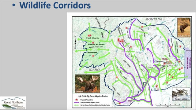 One targeted area for acquisition was accomplished recently in the Duck Creek area near Henry's Lake. In just a short 2 years, with the Nature Conservancy assisting, the US Forest Service acquired 60 acres of "key" habitat for cutthroat trout, which is also key habitat for the other species as well. For humans, they will allow "non-motorized access with camping available within 100 yards (91 meters) of Red Rock Road." Lucky us.
|
 RSS Feed

