|
If there is any doubt that corridors and connectivity don't lead to more restricted land use, that it is just a myth, conspiracy, or just plain ridiculous, following is a discussion of proposed phases at the GNLCC Connectivity Initiative meeting in September, 2015. Aquatic, avian, and terrestrial fauna habitats are included in the connectivity equation, which means corridors for those habitats as well. Starting on page 11 Conservation Outcomes include:
This means that our use of our land will not be allowed, it will be taken for conservation via the creation of different types of corridors. Is that what we want? On their map, the Island Park area is especially hard hit for Big Horn Sheep, Elk, Moose, and Mule Deer migration corridors with targeted areas for acquisitions. 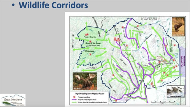 One targeted area for acquisition was accomplished recently in the Duck Creek area near Henry's Lake. In just a short 2 years, with the Nature Conservancy assisting, the US Forest Service acquired 60 acres of "key" habitat for cutthroat trout, which is also key habitat for the other species as well. For humans, they will allow "non-motorized access with camping available within 100 yards (91 meters) of Red Rock Road." Lucky us.
0 Comments
Leave a Reply. |
 RSS Feed

