|
Under the auspices of the Network for Landscape Conservation, the High Divide Collaborative (HDC) held a webinar, Landscape Scale Conservation Through Community Based Collaboration, in August, 2019. How did that collaboration, which is always among yourself and other non-governmental organizations (NGO), and never local citizens, go for you over in the Salmon area during that time, HDC? The video can be viewed here or below. Don't be fooled at the beginning of the video claiming to build collaboration, inviting all stakeholders to the table, learning about their needs, and then incorporating that into goals. That is just the new strategy to groom citizens into believing they are being listened to.
0 Comments
While the Network for Landscape Conservation (NLC) is supposedly only local, it also partners with the International Land Conservation Network (ILCN) and its other Idaho pals under the North America tab including Sawtooth Society and Lemhi Regional Land Trust. NLC recently held a webinar with Michael Whitfield, former High Divide Collaborative Executive Director, as the featured speaker. He recently wrote a white paper for the Lincoln Institute of Land Policy called, Toward Holistic Landscape Conservation in the 21st Century. Among the meanderings of thoughts by an admittedly old man, the paper consisted of the same boring themes of overpopulation, threats of fragmentation, starving people with nowhere to live, and the plight of life. If not depressed prior to reading the paper, one should certainly feel that way after reading it. The whole webinar is about the same diatribe, we are in a crisis, and there is mass extinction going on which necessarily drives the need for protecting land and connectivity. But this focus has lacked full inclusion of all people so now there must be more emphasis on that, after all, we all live in the same world neighborhood. Translated that means there will be targeting of local citizens to engage them in this agenda. Beware. It isn't about collaborating with them anymore than it ever has. It means more pressure to join. There is a special section on the High Divide area that includes how successful collaboration has been in that area, starting at the 22:45" mark. What will Mr. Whitfield do when he finds out that other "stakeholders" don't hold the same ideological beliefs as him? How will Mr. Whitfield manage that level of disagreement?
Mr. Whitfield, if you truly believe in what you say, immediately you should turn your land over to the wild, move to an area of human need where starvation and homelessness abound, with no recognition of jurisdictional boundaries. Give up what you expect everyone else to give up. Live a life of self sacrifice for wildlife. What you say may then appear as those you are sincere in your beliefs and not someone who is unable to come to some resolve about life actually being good and not at the point of doom. A second round of Freedom of Information Act (FOIA) records have been obtained regarding the partnership between the U.S. Forest Service (USFS) and Salmon Valley Stewardship (SVS). There is quite a bit of financial information contained in these records, once again a very large document. A link to those records can be found here. Again, because of the document size, disorganization and duplicates of these records, they will be broken down into monthly quarters Below is the financial records starting December, 2016 through March, 2017. Even though requested, the documents leading up to this agreement prior to December, 2016, who participated in the discussions for the partnership, were not provided. The initial agreement was for $200,000, however by the end of the partnership in 2018, the amount SVS obtained far exceeded that. At the top of each document is the page where the information can be found in the link to the full FOIA document. The initial agreement states it was to develop and execute several projects towards Forest Plan Revision "Across Region 4", but was actually executed across multiple forests outside of Region 4. By the end of March this amount had increased to $396,678, most of which went to salaries. The March 2017 Modification raised the amount by $197,670. Below is the April 11, 2017 invoice submitted by SVS from 1/1/17 to 3/31/17. A second invoice was submitted two days later for the same amount. The period for the document below is from July through September, 2017. An additional amount of $50,000 was provided to SVS by the forest service Washington Office (WO) "for...media materials to solicit public input on Wild and Scenic Rivers comprehensive river management plans (CRMPs)." An invoice was submitted by SVS on July 27 for $163,915. SVS made another Modification request on August 10, 2017 for $128,040 more in funding. Part of this funding was for attending trade shows, maintaining the YFYF website, and recording podcasts. Another $50,000 was provided by the WO for wild and scenic river work. On page 15 of the document below, by August the "overall amount" of committed funds is now at $842,964.00! Below the is October, 2017 invoice submitted by SVS for $119,338.00. Below is the January through February, 2018 finances, including a January SVS invoice for $71,470.00 and another Modification request for an additional $65,257.50 in funding for work on Wild $ Scenic rivers projects. There is also some discussion by SVS about a new partnership, a partnership that was never identified in these FOIA records.... even though the FOIA request specifically asked for information about two additional known media partners. The April through May, 2018 financial document is below. An invoice was submitted by SVS for $161,528. There is also a forest service document showing payment to SVS in the amount of $597,797.00 from April, 2017 through April, 2018. SVS again requested a Modification for $238,081.80 in additional funding, but the forest service began questioning these requests. A "partner" is also again referenced. The July through September, 2018 financial document is below. And additional $41,500.00 was requested but later decommitted after being flagged by the forest service. It appears more scrutiny of SVS funding was starting. A July invoice submitted by SVS was for $230,531.00 which was paid by the forest service. There is also acknowledgement of a partnership with More Than Just Parks (MTJP) and discussion about more partnerships. By August, $170,519.00 in funding was decommitted ... by Region 4 ... because the the "agreement" had "gone national". " The last FOIA information is from October through November, 2018. An Advisory Council was now being formed without any citizen involvement and getting involved in river management plans "that have nothing to do with forest revision". The amount of taxpayer money SVS collected on this partnership with the forest service is obscene. Much of that money went to their media partner salaries, traveling around promoting their project that had nothing to do with forest revision plans, and clearly promoted objectives that align with large conservation groups such as Yellowstone to Yukon and the High Divide Collaborative in which SVS staff are members.
Many questions remain about this partnership. These type of partnerships by the forest service must end, taxpayer money should be used in more responsible ways. The first FOIA request information can be found here. The High Divide Collaborative (HDC), facilitated by the Heart of the Rockies Initiative (HORI), comprised of federal and state government agencies, non-governmental organizations (NGO), and land trusts, held their 7th Annual High Divide Collaborative Workshop this month to discuss strategies and issues.
Eight primary conservation goals were identified for the agenda: Ecological Linkage in core areas; Cultural aspects such as protecting Tribal treaty lands; Working Ranchlands & Recreaton; Clean water; Sagebrush Steppe; Ecosystem support; Healthy forests, and Wildland Urban Interface (WUI) to "allow wildfire to play its natural role". Bottom line, the whole goal is doing nothing except conserving everything. There are a few interesting issues discussed at this workshop, one being the use of "GIS to Estimate Fence Locations for Wildlife Passage". This essentially lays a foundation for creation of migratory corridors, mapping out where they plan to protect those migration paths they design for their connectivity agenda, a tool that "can help landowners and conservation practitioners prioritize fence modification efforts for wildlife passage"...and..."help inform land use planning." The true agenda is found in the Landscape Conservation Design (LCD) led by Sean Finn, Science Coordinator, US Fish and Wildlife Service. LCD is a specific agenda to design the landscape into something it currently is not, deciding where wildlife will live, where you will be allowed to live, and how how you will be allowed to live through defined design practices. That is the purpose of fencing and why Renee Lemon -Land Use Planner, MT FWP was a speaker and who has experience in wildlife connectivity modeling. LCD is "living blueprints for the future" and "desired future trajectories or conditions of the landscape." Much of these issues focus around Secretarial Order 3362 by past Department of Interior Secretary Ryan Zinke. This order, without any congressional approval, essentially directs states and NGOs to map out wildlife and other corridors, decide where they want them to be, and "harmonize" federal and state policies. HDC is not giving up in spite of the massive amount of evidence that their agenda is dictating and controlling land use. The Lemhi river is 60 miles long, as a tributary flows northwest to the Salmon river, feeding into the Snake river, and ultimately flows into the Columbia river. Below is a map of Lemhi River Basin tributaries that are priority areas for conservation. Multiple ranches are dependent on this water for livestock grazing and agriculture. Those who are involved in gaining control over water for fish claim grazing "degrades the riparian vegetation and streambank stability" and "dewatering of the lower river can delay anadromous smolt and adult migrations" occurs from irrigation practices. 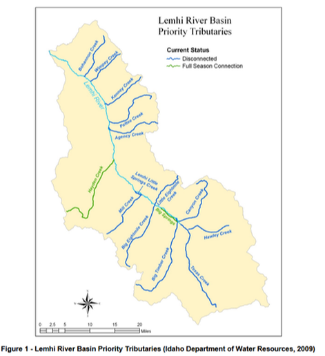 As noted in part 1, multiple organizations are involved in this pursuit of protecting fish, it is all about saving the fish, at the expense of not only the taxpayer, but to livelihoods. Merrill Beyeler, a former Idaho legislator, Lemhi Regional Land Trust (LRLT) Chairman, Idaho Business for the Outdoors board member, Salmon Work Group member, Central Idaho Rangelands Network member which partners with The Nature Conservancy (TNC) and LRLT, and High Divide Collaborative Coordinating Committee member whose mission is conserving land as part of the Heart of the Rockies Initiative is one benefactor of this plot. As part of the Upper Lemhi River Acquisition project, in 2010, Mr. Beyeler was paid $3,426,523 for his conservation easement according to this Columbia Basin Fish & Wildlife program document. The description of the easement agreement follows: "TNC purchased Cottom Ranch in fee in 2008. In the acquisition (involving BPA), TNC will deed the Cottom Ranch property to Beyeler Ranches, LLC but reserve a CE on the property (held by TNC). In addition, as part of the transaction, Beyeler Ranches, LLC will also grant to TNC, a CE upon the Beyeler Ranches, LLC existing ranch. In the end, Beyeler Ranches, LLC will own a bigger ranch, but it will have a conservation restrictions applied. TNC will hold the easements and BPA will have 4rd party rights of enforcement of these easements. Cottom - 1354 acres, Beyeler Ranch 1000 acres." In other words, Mr. Beyeler "entered into a conservation easement with The Nature Conservancy...which...allowed him to purchase another ranch with an existing easement, almost doubling the size of his property." Not bad, over $3 million dollars in his pocket and an expansion of his ranch, including an award. In this CE agreement, Mr. Beyeler agreed to a 20 year restoration project that "consolidates diversions...from the main stem of the lemhi rather than from several of its local tributaries." Mr. Beyeler has a knack for using other funding sources to his benefit, including the taxpayer footing the bill. The Columbia Basin Fish & Wildlife program targets land acquisition from 2010-2032. The consolidation of diversions achieves the objective laid out by the Northwest Power & Conservation Council (NWPCC) to reconnect "tributary streams to the Lemhi River." LRLT bought a CE near Leadore to "permanently protect nearly 10 miles of in-stream and riparian habitat" through a habitat management plan. As more land is taken for fish habitat restoration through CE, expectations for fish protection weighs heavily on other land owners. The unelected Idaho Water Resources Board (IWRB) is pouring thousands of dollars into changing irrigation practices, allocating it to private land owners for fish habitat restoration projects. Once again, the federal outfit BPA, is funding this activity. What happens if a private land owner chooses to not participate? Now, water rights are involved. Water law is extremely complex, however, even though this article focuses on the Lemhi River, this issue is applicable to every Idahoan that hold water rights. IDWR defines a water right as "authorization to use water in a prescribed manner, not to own the water itself. Without diversion and beneficial use, there is no water right." In the Idaho Constitution, Article XV, Section 3 states, "The right to divert and appropriate the unappropriated waters of any natural stream to beneficial uses, shall never be denied...". Beneficial uses include domestic, agricultural (stock and irrigation), mining, manufacturing, and power. It is the duty of IDWR to supervise the appropriation and allotment of water rights. In Idaho, a water right is considered a real property right much like property rights in land. Once established, a water right cannot be denied as long as that water right continues to be used for beneficial use. The Snake River Basin Adjudication (SRBA) was a litigious case that began in 1987 and finally settled in 2014. It determined that priority of water rights "must be quantified" making water rights more clearly defined for administration. One of the affected areas in SRBA was the Lemhi basin, Water District 170, and its associated water districts. Up to this point water rights were established by diverting the water and putting it to beneficial use such as the Big timber Creek, first decreed in 1912, and being measured every year since. This document gives an in-depth explanation of SRBA. Water District 170 was implemented for the express purpose of identifying any and all illegal uses of water, taking our high flow rights, and requiring the measuring of ground water. As a result of the SRBA, Lemhi Basin 74 was required to participate, and in 2017, IDWR proposed an expansion of Water District 170 by combining 12 active water districts within Administrative Basin 74, and placing the administration of those water rights under IDWR, out of the hands of the water districts themselves. The SRBA Basin 74 General Provisions included a provision that 27 tributary streams be administered separately from all other water rights and that diversion and high flow use, such as spring runoff, could be diverted for beneficial use, with existing water rights satisfied. Historically, Lemhi water districts have been properly managing and administering tributary streams to the Lemhi River, but with this proposal, these water districts are being reduced to subdistricts, with IDWR taking over the administration of those districts, including control over the measuring and accounting for ground water diversions, traditionally conducted by the water districts. Under the administration of IDWR, there could be a demand for additional restrictions for future high flow diversions. These high flow periods are needed by ranchers for agricultural purposes, a beneficial use. If IDWR diverts that water it would cause economic devastation to those ranchers. Or perhaps IDWR is looking at it from a perspective of fish. As previously noted, blame is laid upon ranchers for "dewatering" tributary streams, claiming it affects fish habitat. However, in the 2004 BOR Instream Flow Assessment study, it states, "fish populations continue to exist within available physical habitat throughout the year" which does not substantiate the need to deny water rights for fish. High flow water is especially needed because there is no storage system, such as a dam, that will provide the necessary water for irrigation as needed. The issue of high flow water use was adjudicated in SRBA, reaffirming the Lemhi high flow practice through inclusion of the Basin 74 General Provisions. Since water rights are considered real property in Idaho, an analogy would be the state deciding to combine your property with your neighbor, then dictating how that property could be used. There could be nothing more sinister towards property rights. When discussing approval of water right applications in the Upper Salmon Basin Watershed June 6, 2019 meeting notes, IWRB expressed concern "...that transacted water for reconnects such as Big Timber Creek could once again be dewatered if these new water rights are used, particularly on the shoulder seasons." At the same meeting Mr. Beyeler was soaking up more funds for fish restoration projects. Amy Cassel, IDWR, noted spring water runoff is acceptable. However, it has always been unappropriated water, meaning not approved as a water right. If unappropriated, is IDWR planning to take that water only for fish habitat use, devastating the livelihoods of those who are dependent on that water? At the Idaho Water Resource Board (IWRB) July 25, 2019 meeting, a resolution was proposed that "would authorize staff and counsel to retain technical consultants and experts to support the Board's protests to applications for permits to divert from tributaries to the Upper Lemhi River." Clearly the intent here was using more of your tax dollar to fight Idahoans with legal water rights who objected to the IDWR proposal to take the use of their water rights away from them. As a result of this IDWR proposal, major adverse changes to water rights are being proposed that do not align with the SRBA Basin 74 General Provisions. Idaho Code § 42-604 referenced in the order states, "The director may...combine two (2) or more water districts by entry of an order if such action is required in order to properly administer uses of the water resource. Water right users in Basin 74 were properly administering water resources. Again, this is akin to the state combining and assuming control over private property use. Idaho Statute 42-1736B states, "All water plans and development projects proposed by the water resource board shall be subject to review and approval of the legislature" and "To take all necessary actions to assure that Idaho citizens shall not be denied the right to divert and appropriate to beneficial uses." This IDWR proposal was never presented to the legislature for approval, they just moved forward with it. On January 20, 2020, IDWR attempted to do a end run around the SRBA Basin 74 General Provisions for separate tributaries legislatively, essentially tying them all to the Lemhi River, and comingling them. Legal action by ranchers was successful in stopping this, at least for now. Clearly, the IDWR objective is taking control over water rights for their, and others, pursuit of fish habitat restoration, even if it means violating Idaho statutes. Objections to this action by private land owners with water rights were ignored. It appears that if private land owners do not engage in the quest to restore fish habitats through a CE or other restoration projects, the next step is to devise a way in which the state takes control over the use of water rights. With the amount of money and partnerships behind fish and habitat restoration, perhaps IDWR will ultimately do the same by combining tributaries for fish and diversion into the Lemhi River. This action will ultimately destroy a land owners right to use water for beneficial use, and destroy their livelihoods. Lemhi tributaries don't have a big enough flows to support spawning, which flood irrigation does not affect. The goal has been to alter tributary water to a consistent flow state by diverting the streams into one, such as what Mr. Beyeler did on his land for fish habitat and spawning. The BOR studied the Big Timber Creek 2006 to identify stream flow needs for steelhead, salmon, and bull trout, blaming irrigation "dewatering" for problems. What is so crazy about this is that the Bull Trout is a predatory fish towards others, and have a recovery plan of their own, in which the Upper Snake area is included. Spawning times are typically during July-August, well after the high spring runoff. By combining tributary streams into a one flow stream, perhaps the plan is to reintroduce fish with this newly created fish habitat. "Observations" of large bull trout in Big Timber Creek have been reported even though the life histories are unclear. How scientific is that? Idaho Statute 42-1503 states any change on minimum stream flow "will not interfere with any vested water right, permit, or water right application with priority of right date", and "is necessary for the preservation of fish and wildlife habitat". If IDWR chooses to divert tributary streams into one for a minimum stream flow for fish habitat it would interfere with vested water rights. Idaho Statute 42-1501 also states that Idaho streams "be protected against loss of water supply to preserve the minimum stream flows required for the protection of fish and wildlife habitat". Does this mean water supply cannot be used for purposes other than for fish habitat protection? In our form of government, a Republic, a court decision is not law. Laws can only be created through the legislature. There is no law for this IDWR proposal. IDWR admitted in committee that they often use policies instead of rules or laws. In response, Governor Little signed Executive Order 2020-02 which requires Idaho agencies to limit and consolidate "agency guidance", including a statement indicating that it is not law. IDWR created this proposal, presented it to those with water rights, ignored their objections, and have made a decision to move forward with it as if it were the law. Idaho Administrative Rule 025-01 states "Applications to appropriate unappropriated water...will be evaluated using the criteria of Section 42-203A, Idaho Code, which requires an assessment to be made of the impact of the proposed use on water availability for existing water rights...and the effect of the proposed use on the local public interest". The impact of taking unappropriated high flow water will destroy ranchers in the Lemhi area. It is clear that there is a nefarious agenda to use certain species of fish, their habitat or lack thereof, and interfere with water rights which are a real property to those Idahoans who hold those rights. Millions of dollars, most of which are your tax dollars, are being spent to acquire land, change the landscape into something it isn't, and create habitats which never existed. If a Beaver understands that a spot in the water isn't suitable for a dam, why do humans think they can do better? To those who are involved, quit messing with Mother Nature, follow the law, and quit violating property rights.
Much interest in the Lemhi River and its tributaries has been around for some time. According to the Idaho Water Resource Board (IWRB), the "Lemhi River is one of the cornerstones of Idaho's Salmon Recovery Effort." In 2004, the Bureau of Reclamation (BOR) conducted a study, Instream Flow Assessment Big Timber Creek, Idaho, which covered stream flows and future needs for fish habitat protection. Idaho Fish & Game (IDFG) conducted another study in 2006, Bull Trout Migratory Dynamics and Life History in the Lemhi River Sub-Basin. This study determined Bull Trout "distribution has been restricted by water withdrawals from tributary streams." End result, "Efforts are under way at this time to connect Big Timber Creek perennially to the Lemhi River. Once the project is completed, it is expected that a minimum discharge of 4.5 cfs will continually enter the Lemhi River throughout the year." The stage is being set for relinquishing this water from private property to fish. In 2008, the Idaho Office of Species Conservation (OSC) put forth the Upper Lemhi River - Acquisition proposal. Conservation easements and simple fee acquisitions were intended to "permanently protect in-stream and riparian habitat, improve river flow in the Lemhi River, and assist in reconnecting tributary streams to the Lemhi River to benefit all life stages of Snake River spring/summer-run Chinook and Snake River steelhead". Several ranches were involved in this proposal. Since that time there has been a growing, and concerted effort to take control over water, even water that flows over private property. The full proposal can be found here with IDFG, Idaho Department of Water Resources (IDWR), Bureau of Land Management (BLM), The Nature Conservancy (TNC), Upper Salmon Basin Watershed Program (USBWP), and Bonneville Power Administration (BPA) all being involved. BPA is part of the U.S. Department of Energy (DOE), sells electrical power to fund itself, and includes Idaho. Another BPA partner is the National Fish & Wildlife Foundation (NFWF), which was created by Congress as a " private conservation grant-maker". BPA also funds the Columbia Basin Water Transaction Program (CBWT), which was "developed in 2002 to address chronically diminished stream flows in tributaries of the Columbia River.", and "works through locally based entities to acquire water rights voluntarily from willing landowners". In this program, BPA "works in cooperation with the Northwest Power and Conservation Council (NPCC) and with support from Altria.", IDWR, and Trout Unlimited. NPCC authorized western states to "develop a regional power plan and fish and wildlife program". IDWR has its own Water Transaction Program (WTP) specific to the Upper Salmon River Basin, for the purpose of "improving flows in streams and rivers". Their partners include the BPA, NFWF, NPCC, and OSC. According to their brochure Idaho is "determined" to reconnect tributaries to recover ESA-listed fish, with the Big Timber Creek being the highest priority, claiming that it is dewatered. With the Upper Salmon Basin Watershed Program (USRBWP), the IWRB reviews projects to ensure that transactions are developed on high priority stream reaches, without naming the other partners. However, USRBWP has an extensive list of partners that includes federal and state governments, BPA, Tribes, land trusts, and non-governmental organizations (NGO). Another organization, Western States Water Council (WSWC), consisting of governor appointed representatives in 18 western states, was created to facilitate cooperation in the conservation, development and management of water resources. Its "Vision" statement "transcends political and geographic boundaries" with all levels of government prioritizing "the collection, analysis and open sharing of reliable data regarding water availability...and usage". In other words, jurisdictional boundaries are irrelevant. WestFast was created to collaborate with 12 Federal agencies that have water management responsibilities in the West, and coordinate Federal efforts regarding water resources. WSWC also supports the S. 2156 Secure Water Act which includes "basin-wide coordination that involves all governmental entities", "grants or...cooperative agreements to assist states and other non-federal entities in carrying out a range of water use efficiency improvement", and develop a "national groundwater monitoring program...and the establishment of a national water availability and use assessment", along with other massive data gathering schemes. However, data collection on water in the Lower and Upper Lemhi River Basin was already conducted for BOR, OSC, and IDWR in the 2006 Mike Basin Model, an integrated water resource management and planning computer model that integrates a GIS with water resource modeling. The intent of using this model was for improving stream flows for fish. Both basins were analyzed with the intent to merge both for creating a comprehensive model of the entire Lemhi River Basin. "The United Nations FAO 56 method for evaluating crop evapotranspiration and computing crop water requirements has been recently incorporated into MIKE BASIN"...and..."could be incorporated into future upgrades of the LRMBM." (pg 76). Recommendations include the need for more data collection and analysis, but the model "resulted in the development of skeleton surface water budget model for the Lemhi River and 12 tributary basins", as well as creating "a water rights inventory for diversions". The Mike Basin Model is now known as the Mike Hydro Basin and is "designed for analysing water sharing issues at international, national or local river basin scale." The Western Watershed Project (WWP) is another NGO whose mission is to "protect and restore western watersheds" with the Lemhi River watershed being one focus area. Partners include the Center for Biological Diversity (CBD) whose mission is to "save life on earth" and "is dedicated to promoting sustainable development. Conceived as a practical tool for translating the principles of Agenda 21 into reality". CBD is a partner with Advocates for the West that pays millions of dollars for litigation on the behalf of CBD and multiple other NGOs. As seen by all of this information, there are specific, very well funded organizations, in partnership with state and federal agencies that are targeting water and private land owners who live in not only Lemhi county, but in the rest of Idaho. But others are involved in the pursuit of protecting fish, their habitat, and conserving water because of either the alleged current, or predicted future, water crisis, which is all tracked. Conservation easements (CE) are part of this plan. In 2015, the Lemhi Regional Land Trust (LRLT), in partnership with the BPA and OSC, bought a 4,682 acre CE to "permanently protect nearly 10 miles of in-stream and riparian habitat" near Leadore. BPA provided the funding for this CE, with the LRLT holding the easement. This CE was also intended to "partially mitigate the impacts to salmon and steelhead from the construction, inundation and continued operation of federal hydroelectric dams" in which BPA participates. The objective was partly for improving salmonid habitat. This land was part of Leadore Land Partners, a limited partnership created in 2000 based in Missoula, Montana, and is owned by Karl & Donna Tyler. According to this document the Tylers were paid $7,300,000, and $680,000 for "stewardship funding". Idaho also contributed $3.5 million of your tax dollars towards this CE. A Riparian Habitat Management Plan for this area was finalized in 2016. As noted by NPCC, this CE was just one of several being pursued on four ranches beginning in 2008.  Pursuit of conservation easements will ultimately assist in achieving the goal of controlling water in Lemhi county, with your tax dollar providing monetary benefits to land owners who participate in signing over their land. In part 2 more benefits will be exposed, along with the potential devastation to land owners who choose to not participate.
The Idaho Rangeland Resources Commission (IRRC) was created by the Idaho legislature in 1994 (Title 58 Chapter 14), comprised of five Governor appointed voting members that includes Royce Schwenkfelder, Ross Goddard, Darcy Helmick, Todd Holbrook, and John Peavey who come from different areas of the state. There are also “permanent” non-voting advisory members including the BLM State Director; USFS regional supervisors; U of Idaho Agriculture and Life Sciences Dean; ID Department of Lands, ID Department of Agriculture, and IDFG Directors; and the Society of Range Management President, among others. The IRRC website states "It is a state agency with an educational mission" and was created to "Foster understanding by creating collaborative partnerships to sustain healthy rangelands."
Some of their "education" programs include how to interact with livestock when recreating through their "Care & Share" program, creating teacher resource guides and curriculum for K-12 students, creating videos that promote their purpose, and education on wildfires. However, looking at the curriculum, these programs are really promoting non-governmental organization (NGO) ideology and agendas, paid for with our state tax dollars. The IRRC website is fairly vague about its wildlife objective, other than how ranches are valuable for wildlife habitat, but there is a link to The Nature Conservancy (TNC) for more information. IRRC Executive Director, Gretchen Hyde, is Vice Chairman on the Idaho Rangeland Conservation Partnership (IRCP) Steering Committee, along with federal and state agencies, and TNC. Seeing development as one of the "threats", IRCP acts "as a statewide network to support locally lead collaboratives" that "conserve and enhance the social, ecological, and economic values of rangelands". Their work is a "landscape scale" endeavor, meaning no recognition of jurisdictional boundaries, to develop management plans for outcome-based land management. The IRCP has also held workshops with the USDA Working Lands for Wildlife that "systematically" targets conservation efforts on working landscapes. IRCP Coordinator, Brenda Richards, even gets together with land trusts to support "voluntary land conservation". Ms. Hyde also serves as secretary on the Idaho Environmental Forum (IEF), an organization that includes the Idaho Conservation League (ICL), Governor's Office of Species Conservation (OSC), and USFS. In October, 2019, the IEF welcomed the new Idaho NGO heads as guest speakers from the ICL, TNC, and Idaho Rivers United. OSC Director, Scott Pugrud, was the forum chair and moderator. In March, 2019, IDFG Wildlife Program Coordinator Gregg Servheen, spoke on the importance of wildlife migration for connectivity and highway crossing technology, a very heavily promoted NGO objective for connectivity using wildlife overpasses. The Wild & Scenic Rivers Act in Idaho was celebrated by IEF in November, 2018. There was also a discussion on "Planned Communities: A Tool to Control Sprawl, or Encourage It" held in April, 2018. Back in September, 2017, a forum was held on the Politics of Protected Areas: National Parks, Monuments, and Wilderness, with ICL director Rick Johnson. While the IEF claims it takes “no positions” or advocates “no causes” it seems their activity is heavily influenced by NGO objectives and involvement, and they do track legislative activity. How much of this ideology does Ms. Hyde bring back to the IRRC? Historically, ranchers have been the most responsible in protecting the land. NGOs want to change that into their notion of how the land should be managed which is conserving it. There could be nothing more devastating than not working or using the land, that is what destroys it. Participation in this agenda will only worsen the condition of land, just as the forests are being destroyed by non-use. The IRRC is not a working land owner collaborative. It is a state created organization for the purposes of embedding NGO objectives, through educational programs that mislead children, and involvement in other well-hidden activities, that includes the federal government. These collaboratives all need to get out of our lives and citizens need to take back the management of our land within our jurisdictional boundaries. Ranchers to not need to change how they care for the land into a conservation zoo. No more "cooperative, consensus, collaboration" activity spearheaded by NGOs with federal and state agencies that exclude or allow only minimal local citizen representation. The High Divide Collaborative, (HDC) held a webinar in August, 2019, facilitated by Bray Beltran and Emily Harkness from the Heart of the Rockies Initiative (HOTRI). The webinar started with the claim that the HDC is a "community based collaborative" that works across jurisdictional boundaries. There is nothing community based about this group. A few webinar highlights will be pointed out but the full webinar should be listened to in order to understand this massive, government sanctioned, agenda against Idaho, primarily central Idaho. The High Divide area only exists "conceptually", encompassing 25 million acres for connectivity, including private property that depends on grazing allotments, and that land is needed for their connectivity agenda. This and recreational land is seen as necessary for the ecological and social "integrity" of the area. Funding for their agenda came from the Land and Water Conservation Fund (LWCF) in the amount of $30 million dollars between 2016-2018 as an "investment" in restoration projects for conservation. What did they do with part of that money? Purchased inholdings, more private property under government control. The question HDC now has is how to "protect" that investment. It means exactly what it says, "protect" from disturbance, practices, and use they don't find acceptable. "Shared priorities" within the collaborative include linkages with working ranches "nationally", the importance of recreation land, and "open land in wildland urban interface" among others. These are not community based priorities, they are shared environmental group and government priorities. This is validated by the graphic shown in the webinar that is loaded with only federal and state governments, land trusts, Tribes, and non-governmental organizations (NGO), many of which do not even live in the area or Idaho. That is who comprises the HDC with the government list being quite extensive. The new ruse is "listening" to landowners, but it is really the "act" of listening, not actually listening, and by doing so "earning" our trust. They also encourage this facade by asking questions. Don't be fooled by any of it. For some unknown reason they think it is their job to "conserve a safe place for wildlife and families...and the community', and provide a "safe place" to voice differences. Listening is a pretense. HDC and the rest need to be told to stay out of our communities and there will be no participation with them. With "conflict reduction" comes their answer for how they want us to manage our land. As they continue to pursue unreasonable high Grizzly populations, we humans must make way to avert conflict with them and plan for conserving their right to passage. Planning includes removal of dead wildlife in their path, composting sites for those dead animals, human presence on the range watching for problems (like there is the manpower and time to do this by private land owners), and using bear resistant garbage cans. Telling us how we should manage land is the ultimate goal. Finally a few questions were answered, one of which was pointing out individuals in the HDC hold the same ideology, where is there room for the voices that disagree? Some fumbling and stumbling for an answer on that one was interesting. Another question was about land trusts buying land outright in which the moderator disagreed, stating the use of conservation easements (CE) was for "keeping people on their land", especially those who were struggling to keep their land and could "take advantage" of CE tax breaks. It is worth listening to this video, especially for those in central Idaho, but is applicable in all of Idaho. Collaboratives are nothing more than the federal government executing a conservation agenda via their NGO buddies. The plan is taking land, then dictating how it should be used. Never forget our Republic was based on local government, representation closest to the people. HDC and the rest violate this principle, have no respect for our Republic and governing system, and they need reminding that the authority lies at this level.
In September, 2019 the Roundtable on the Crown of the Continent (COC) held a conference that included participants from multiple Tribes, governments, non-governmental organizations (NGO), conservation initiatives, land trusts, and universities. Their goal was discussing how they can take control over land use. Participants from Canada were also there, from Glacier National Park and Waterton Lakes National Park. Another participant was Gary Burnett, Executive Director Heart of the Rockies Initative. He spoke about the High Divide Collaborative and the need for conflict resolution for connectivity. Another subject was increased potential for conflict with landowners as the range for Grizzly bears expands. That is a clue about the deliberate agenda to expand Grizzly populations for that very purpose to justify using them for corridors. Even though this initiative does not expand into central Idaho, the goal is "connecting" the COC to the High Divide target area. Both are seen as landscapes to be taken over. Areas these groups want control over include tourism, natural resources, habitat, and wildlife. There is also discussion about the need to protect areas for non-use, using conservation easements and designations as protected areas. This is a large area and will heavily impact Idaho. The document can be read here. 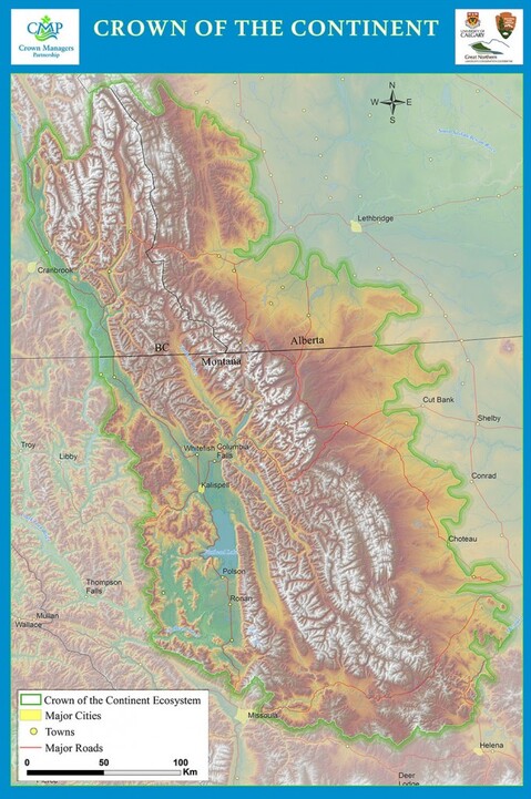 While Landscape Conservation Design (LCD) is applicable to all areas in Idaho, once again Custer and Lemhi counties, located in the High Divide region, are poster case studies for LCD implementation. Recommended Practices for LCD was announced by the Landscape Conservation Cooperative Network (LCCN) in September, 2018, describing LCD as "...a partner-driven approach to achieve a sustainable, resilient socio-ecological landscape. It is an iterative, collaborative, and holistic process resulting in strategic and spatial products that provide information, analytical tools, maps, and strategies to achieve landscape goals collectively held among partners." The process includes initiating LCD, convening stakeholders, assessing future desired conditions, and creating spatial and strategy designs. What this gibberish really means is federal and state governments join non-governmental organizations (NGO) in collecting multiple types of data to determine what an area currently looks like and then decide how they think it should look for conservation and connectivity, or rather sustainability. This includes manipulating citizens with fluffy words that are vague and nowhere close to telling the truth about what they are doing. On page 19, the High Divide (HD) area is highlighted as a Section 2 Example/Case Study that describes specific applications of the practices. The complete area can be found on the LCD Mapper. On this map, scroll down on the left to the High Divide area, Phase 1. If you click on "show more" at the bottom, it brings up all the involved parties, including the Heart Of The Rockies Initiative (HOTRI), Salmon Valley Stewardship (SVS), Lemhi Regional Land Trust (LRLT), Region 4 Forest Service, multiple NGOs, federal agencies, Idaho Fish & Game (IDFG), and many others. HOTRI and its facilitated group, the High Divide Collaborative (HDC), formed in 2013, are identified as leading the design process which serves as the "framework for conservation planning and delivery in the High Divide landscape." While recognizing mistrust of outside interests and government agencies, the HDC still proceeded with landscape conservation funding through the federal Land and Water Conservation Fund (LWCF). Even before the Recommended Practices LCD document was created, HDC was already well on its way implementing LCD through SVS as shown by the following examples. The Central Idaho Public Lands Collaborative (CIPLC), created by SVS, is achieving one LCD process with its working groups. According to LCD design, a Bridging Organization "identifies and convenes an inclusive set of stakeholders...within the defined geography...that use specific mechanisms such as working groups to link and facilitate interactions among individual actors". Working groups are used to designate "priority management areas" for the "amount of habitat" needed for objectives. and geospatial data is used to create maps that "evaluate the potential of every acre of habitat to support a species’ population". CIPLC working groups include Socio-Economic Impacts, Grazing, Forest and Watershed Health, Recreation, and Lands and Minerals. SVS recently launched the Forestry and Fire working group, and will be launching the Wildlife Connectivity working group. Another LCD task accomplished by SVS was convening an "inclusive" set of partners which included ranchers and local "stakeholders". Of course, federal and state agencies were in line to be included along with other NGOs. As for building trust, and claiming to listen "to all stakeholders"...and creating "recurring opportunities for all perspectives to be heard", they are only referring to themselves. True to its LCD task, the HDC Coordinating Committee has held workshops and celebrations of themselves. The Lemhi County Economic Development Association (LCEDA) tracks the local economic data, which is shared with Headwaters Economics (HE). Socioeconomic data collected by HE on Custer and Lemhi counties is highly detailed as seen on this map, both reports receiving "significant BLM and USFS financial and intellectual contributions to the operation and content." These reports also seem to be consistent with the 2018 SCNF socioeconomic assessment. The socioeconomic piece of LCD is for the purposes of dictating how communities function. HE and Executive Director Ray Rasker are HDC partners along with the Central Idaho Rangeland Network. HE uses data to make future investment decisions on recreation, healthcare, and education, which is why LCEDA, as part of LCD, may be spearheading the Education Project. LCEDA was very clear on their intentions in 2011, "Sustainability can be achieved through changing the community." LCD "Primary conservation goals" were identified for their "shared vision for the future of the High Divide landscape." Their "shared conservation goals has yielded strong support from our congressional delegations..." and "...has resulted in substantial federal investments in our priority conservation initiatives." The money just keeps pouring in for the takeover of local land management. In order to sustain the Collaborative, the "LCD must clearly lead to greater opportunity for effective conservation delivery". It is up to citizens to stop that delivery. A pretty hefty federal investment was made by the Great Northern Landscape Conservation Cooperative (GNLCC) for these objectives in 2015-2016, which included funding of $150,000 from the U.S. Fish & Wildlife Service (USFWS) and $157,100 from other sources, a total of $307,100. The purpose of this support was to "identify and evaluate future landscape configurations...while conserving the High Divides unique landscape resources...emphasize wildlife connectivity between large protected core areas: Yellowstone, the Crown, and central Idaho"...and..."coupling socio-economic data and trends with conservation modeling in a holistic landscape conservation design process." The Center for Large Landscape Conservation (CLLC) also had their fingers in the game in 2014, including IDFG, Y2Y, and the USFWS, In the Conserving an Intact and Connected GNLCC Landscape word document at the bottom of the above link, the High Divide area was summarized as having convened the HDC, assessed ground conditions, created spatial and strategic LCD to inform habitat connectivity decision making, with LWCF funding being committed for "major land acquisitions, conservation easements, and restoration". This was during the time of the GNLCC Ecological Connectivity Project which created spatial design and strategic approaches for LCD. The Lemhi Regional Land Trust (LRLT) is the HDC partner that pursues conservation easements and other land acquisitions while SVS is involved in restoration projects through their Lemhi Forest Restoration Group. This is how the scam works, the GNLCC, now defunded, was a conglomerate of government agencies and large landscape initiatives such as the HOTRI, Y2Y, CLLC, Rural Voices for Conservation Coalition (RVCC), and land trusts. HOTRI created the HDC after SVS was established. In partnership with governments, SVS then proceeded to implement LCD objectives at the local level with their NGO buddies with funding primarily coming from your tax dollar. All of these groups and individuals think they have the right to determine how they want your community to look, how the land should be managed, and how citizens should live while sharing data to create those changes. For the claim that "The recommendations, findings, and conclusions in the guide are those of the authors and do not necessarily represent the views of the U.S. Fish and Wildlife Service." What a bunch of crock, they sure don't have any problem posting it on their website. All of this is an internal government led coup d'état over the foundation of our Republic. Bottom line, this is a clear validation that federal and state governments are conspiring with NGOs to redesign Idaho land for conservation and communities, bypassing jurisdictional boundaries, omitting citizen involvement, and most obnoxious of all, violating every aspect of our Constitution and laws. Implentation of LCD has been in the works for years, a complete takeover of Custer and Lemhi counties by a tyrannical government. Citizens are the only ones who can stop it, and that time is now. |


 RSS Feed

