|
It is often difficult to explain something that doesn't make sense in a way that it does make sense. Starting with the foundation of the insanity may be the place to start. It was previously revealed that the Bureau of Land Management (BLM) adheres to international standards for conservation. Although "fragmentation" and "habitat" are frequently referenced in the Upper Snake East Travel Management Plan Draft Environmental Assessment in relation to multiple different types of species, the word connectivity isn't really prominent. One purpose of moving and decreasing the number of these trails is to repair fragmentation and restore land for connectivity. Habitat connectivity is the insane notion that because of human activity, roads, and development, habitat becomes fragmented. In other words, the land that maintains connectivity, corridors and stepping stones, is disrupted. In the graphic below, it is conceived that there must be a connection between patches in order to maintain connectivity. This habitat includes all ecological elements, including vegetation and wildlife. If damaged, that area must be restored in order to re-establish connectivity. Maintaining connectivity protects biodiversity, or so they say. 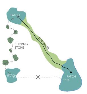 The 2021 White House America the Beautiful initiative, which outlined its conservation goals, includes its 30x30 agenda, a plan to conserve 30% of land by 2030. Other than declaring more national monuments for banned use, it has taken two years until now to get going on this. However, it now appears the aggressive move is on for placing land into conservation. It is clear that using habitat connectivity is at the core of meeting the 30x30 goal.
In March 2023, the Council on Environmental Quality (CEQ) put out a memo that outlined the new requirement that all public land use planning must include connectivity. Maybe the Chair should have checked with the BLM, as it had already instituted this policy in November, 2022. Somehow, the BLM sees "“wildlife and fish” as one of the resources expressly included in the definition of “multiple use” (Section 103(c)" in the Federal Land Management & Policy Act (FLPMA), and justifying its use for connectivity. BLM land must now be evaluated to determine "if existing land use plan decisions are (or are not) restoring, maintaining, improving, and/or conserving areas of habitat connectivity" and "incorporate areas of habitat connectivity". From that, the land use will be planned around habitat connectivity, which plays into where and why trails are being moved and reduced, as this policy includes "Travel management implementation". The Center for Large Landscape Conservation (CLLC) and Network for Landscape Conservation (NLC) are two organizations ready to jump on this as connectivity is their heart. As the name implies, the NLC is a network of environmental groups as well as government agencies such as the U.S. Forest Service. In February, 2023 it held a webinar that discussed "Insights into the new Global Biodiversity Framework" (GBF) that came out of COP 15, held in December, 2022. Also attending COP 15 were officials from the Biden, State, and USAID departments. Even though the U.S. is not a signatory of the Convention on Biological Diversity, it is an "observer" to support the GBF, its outcomes in America, and its 30x30 agenda. The CEQ Chair, the one who can't keep dates straight, was also present, lending her support and commitment to the GBF. The GBF also meets the 2030 Agenda for Sustainable Development. Along with CLLC celebrating this framework, both of these two organizations have had direct influence on government policies on integrating habitat and wildlife connectivity into federal planning and decisions. The White House Council on Environmental Quality issued guidelines that "incorporate the objectives in this guidance into agency actions". Travel Management Plans are one area where this connectivity agenda is being used. There are four GBF goals. Goal A focuses on "the integrity, connectivity and resilience of all ecosystems are maintained, enhanced, or restored". Within these 4 goals are 23 targets to be met by 2030. This is the core of 30x30, using biodiversity to take land for conservation as outlined in Target 2. The America the Beautiful 30x30 agenda originates from Target 3 which ensures the conservation of 30% of the land and inland waters. Target 4 calls for "management actions to halt human induced extinction of known threatened species and for the recovery and conservation of species". Target 14 ensures "the full integration of biodiversity and its multiple values into policies, regulations, planning and development processes" which are being implemented through the BLM. Following COP 15 in March 2023, the White House Council on Environmental Quality issued guidelines "for ecological connectivity and wildlife corridors" that "incorporate the objectives in this guidance into agency actions". Travel Management Plans are not the only area where this connectivity agenda will be used. In a NLC webinar, as attendees to COP 15, it was discussed how the GBF is part of the America the Beautiful 30x30 agenda, and as a U.S. observer, it will help to implement GBF objectives. Indigenous rights were also heavily emphasized. Not surprisingly, it was also revealed that about 2,000 corporations were present at COP 15 to develop markets for this agenda, Nature Action 100 being one of them. Like the proposed conservation leasing, public land is being monetized, not for our right to use the land, but to conserve it for the purposes of making money for the government. The Department of Interior (DOI) also held its own little party in March of this year, celebrating its conservation agenda, even with Biden in attendance, who gave kudos to Rep. Mike Simpson "to bring healthy and abundant salmon runs back to the Colorado [Columbia] River system." (This is in reference to Simpson wanting to remove dams. Parenthesis is to fix Biden's gaffe. His remarks begin at the 37" mark in the video). Nice to know we have an Idaho representative enmeshed with a president and not the people. Biden even referenced running roughshod over private land for this agenda. In the video of the DOI event, there were multiple Native American speakers and again, a very heavy emphasis on Indigenous rights. At the 11:25 mark, CEQ Chair Brenda Mallory, a COP 15 attendee, spoke. She mentioned the same, connecting habitat across private land, infusing equity and justice into the use of land, and was excited the president could do all of this by just using his pen. So, the upshot is that public land agencies will be integrating connectivity into all land planning, resulting in a reduction of land use for the protection of biodiversity, as outlined by organizations in which these agencies have made international agreements. Also on the horizon, these agencies are looking to monetize this work, making the land a money-making machine for them. Who then will control how the land is used? Be on the lookout for GBF implementation on BLM and other public land in your area. Land use planning is now about connectivity and eliminating the use of land. Understand your enemy. Watch the videos. These directives are not based on the law. It is nearly impossible to find any government agency that is not tied in with corporations, foreign governments, environmental and other radical non-profit groups, and despotic organizations such as the UN. The U.S. has not followed the Constitution for decades. Until this is realized by all, and choose to do something about it, we will fail in getting our country back.
0 Comments
Submitted by Ken Watts (published with permission, part 2 next week)
BLM’s Upper Snake East Travel Management Plan is definitely something to be concerned about. BLM quietly released a proposal of the Upper Snake East Travel Management Plan on their website on March 27th. They are seeking public input during a 30-day comment period on proposed alternative and resource analysis. Interesting fact is that they did not reach out to local OHV riding groups, Recreational dealers of motorized Off Highway Vehicles (OHV) or any local news stations about their press release. This is a big deal. The Upper Snake East Travel Management Plan covers approximately 126,000 acres of BLM managed land scattered throughout six counties in Idaho namely Fremont, Clark, Teton, Madison, Jefferson, Bonneville, Bingham and Power. Over 850 inventoried routes could be affected by their proposal. Island Park Caldera trails will be affected. Their plan is comprehensive in that it addresses access for recreational, traditional, casual, agricultural, commercial, and educational uses as well as access for resource management purposes. It also considers all modes and conditions of travel on public lands, including typical highway vehicles (low clearance sedans and trucks), off-highway vehicles (OHVs), motorcycles, utility terrain vehicles (UTVs), all-terrain vehicles (ATVs), snowmobiles, bicycles, e-bikes, equestrian, and foot travel. BLM clarifies in their news release that Snowmobiles are OHVs, so OHV route designations in the Upper Snake East Trail management plan will apply to snowmobile use as well. BLM claims the Travel Management Area provides valuable habitat for several special status plant species. It also provides valuable habitat for special status wildlife species, including bald eagle, Canada lynx, Columbian sharp-tailed grouse, ferruginous hawk, Greater sage grouse, grizzly bear and yellow-billed cuckoo. The sagebrush communities in the travel management area provide habitat for Greater sage grouse and wintering big game species. The travel management area also provides habitat for Yellowstone cutthroat trout, which occur in numerous perennial streams and some lakes and reservoirs. They are using these habitats as their reasoning for closing the trails. There are many special designation areas within the travel management area—they include the Game Creek Research Natural Area, Henry’s Lake Wilderness Study Area, Snake River Islands, Henry’s Lake Area of Environmental Concern, Snake River, Pine Creek Island, Reid Canal Island, Squaw Creek Island, South Fork, Teton River, Canyon Creek, Badger Creek, and Bitch Creek. Wild and Scenic River segments; Snake River Special Recreation Management Area, North Menan Butte, Butte National Natural Landmark, Sand Creek, Deer Park, Market Lake, and Tex Creek Wildlife Management Areas, Cress Creek National Recreation Trail, and the Nez Perce National Historic Trail. The Ft. Henry Historic Byway, Mesa Falls Scenic Byway, and Teton Scenic Byway extend through the travel management area as well that will be affected by their proposed closures. Upper Snake Field Manager Brandon Anderson said the “Plan will help the BLM and our partners provide a long term and sustainable transportation system that promotes access to public lands.” After reading their alternative proposals I am afraid the BLM’s plan will basically eliminate almost all access to public lands. Comments on this plan can be made at this link, click on the green Participate Now link on the left, and choose Alternative A. The comment period ends on July 10, 2023. (Next week, the proposed alternatives will be published. Get involved NOW!) While this information is about southeast Idaho, the issue is relevant for all Bureau of Land Management (BLM) land throughout Idaho. In March 2023, the BLM released its Upper Snake East Travel Management Plan Draft Environmental Assessment (EA) that affects Fremont, Teton, Bonneville, Madison, Jefferson, Bingham, Power, and Clark Counties. 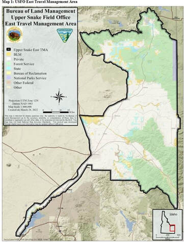 The plan "proposes a network of designated routes and trails for managing travel" in these areas that includes "highway vehicles (low-7 clearance sedans and trucks), off-highway vehicles (OHVs), motorcycles, utility terrain vehicles (UTVs), all terrain vehicles (ATVs), snowmobiles, bicycles, e-bikes, equestrian, and foot travel." What it really means is that these modes of transportation are being targeted for a reduction, and in some cases, full elimination, for use on public land. The basic gist of this BLM plan is to take current trails, remove them from use for restorative work, and then build new trails that will be reduced in number, or have more restricted use.
Yes, it is back to the old adage that humans are destroying the environment and need to be banned from using it. Environmental damage claims include loss of biodiversity from compacted trails, wildlife "harassment", excessive noise, and watershed disturbance. In the four alternatives, the description of OHV use is broken down into Open, Limited, and Closed (pg 16). A breakdown of alternatives in Appendix F (pgs F7-F13) includes A, which is continued use with no changes; Alternative B, which is closed to all activity; Alternative C, which is limited use; and Alternative D, which is Open, meaning year round use. Alternatives have also been classified with an Emphasis, covered on pages 108-109. These are all compared to Alternative A, which is no change, regarding reduction in use. Alternative B has a Natural Resource Emphasis (pg 37) which, as an example, includes decommissioning trails for reclamation, then constructing new trails that have no motorized use. Multiple Use Emphasis is Alternative C (pg 39), which ironically goes on to describe the reduction of use. Alternative D is an Access Emphasis (pg 41), which similarly describes how much reduction there would be for use. Throughout the document, there are multiple charts detailing the impact of how the land is damaged and can be improved, what species are affected, and how this plan with its different alternatives will protect everything. This information contained here is only a very limited summary of the plan. Bottom line, this is nothing more than an attack against OHV and non-OHV use (pg 112) on public lands, and that is clearly blatant as outlined in Appendix C. And just where does the BLM get its authority to do any of this? As responsible, accountable government employees, all of their authority and right to make these changes are listed in the plan itself. But the truth is, there is no law for what the BLM is doing, and (c)"Authorization means any...determination, or other administrative decision issued by an agency that is required or authorized under Federal law in order to implement a proposed action." Starting with Appendix D(D-1), Policies, Statutes, and Guidance, the first policy cited is 43 CFR Part 8340: Off-Road Vehicles. CFR stands for Code of Federal Regulations, the government rules published in the Federal Register that are supposed to reflect the intent of laws passed by Congress. So the BLM is basically saying its own rules gives it authority to do what it is doing in the plan, because there is no law to cite. Going back to 43 CFR Part 8340, it states one authority for this rule is E.O. 11644. Well, this E.O. (Executive Order) was created in 1972 by President Nixon, it was never a law. He created this to "establish policies and provide for procedures that will ensure that the use of off-road vehicles on public lands will be controlled and directed", and in "furtherance of the purpose and policy of the National Environmental Policy Act (NEPA) of 1969 (42 U.S.C. 4321)". The second cited authority is E.O. 11989 by President Carter in 1977, which basically excluded the military and law enforcement from these rules, but also dictated that OHV use causing "considerable adverse effects on the soil, vegetation, wildlife, wildlife habitat or cultural or historic resources of particular areas or trails of the public lands, immediately close such areas or trails to the type of off-road vehicle". So Mr. Dictator Carter made up his own law to close areas that the BLM is using in part to justify its actions while modifying NEPA. "The United States Constitution permits federal agencies to promulgate rules to enable Congress’ legislation", not executive orders. “The President’s power to see that the laws are faithfully executed refutes the idea that he is to be a lawmaker,” Justice Hugo Black said in the Youngstown Sheet and Tube Co. v. Sawyer case with regard to executive orders. Clearly, the E.O.s by Nixon and Carter were creating laws regarding OHV use on public land. Several legitimate laws are cited as the authority for 43 CFR Part 8340, that is laws that support the rule, including the Federal Land Policy & Management Act (FLPMA), but none of those laws address OHV use. FLPMA instead states that lands (8) "will provide for outdoor recreation and human occupancy and use". The draconian OHV rules in the plan clearly violate (7) "goals and objectives be established by law" because there is no law on OHV use, but there is for the establishment of trails. Does the BLM even understand there is no OHV law to follow for this plan? While 16 U.S. Code § 1531 is also cited as an authority in the CFR, nowhere does it state that public use can be limited or banned. Take note of (a)(4), which states "the United States has pledged itself as a sovereign state in the international community" and to "maintain conservation programs which meet national and international standards is a key to meeting the Nation’s international commitments". More to come on that. 16 U.S. Code § 1281 is worth reading, and 16 U.S.C. 1241 says to "encourage and assist volunteer citizen involvement in the planning, development, maintenance, and management, where appropriate, of trails", Were any OHV or non-OHV users, or any county citizens for that matter, involved in the development of this plan? Appendix A, References (A1-A5), primarily uses only government data, which may be a violation of the Data Quality Act. Has the BLM looked beyond its own data for other studies? For example, the plan states, "It is highly likely that recreation visitor numbers in the TMA would continue to increase in the future. A travel route network that provides for a wide variety of structured motorized and non-motorized opportunities and experiences is more apt to reduce user inclination to travel off-route. This can provide for increased user compliance with route designations which helps to minimize OHV use-related damage to unique and sensitive natural and cultural resources. A travel network that closes and reclaims more routes to year-round OHV use would provide for higher quality recreation experiences for non-motorized users than a network that designates more routes as open to OHV use (pg 113)". Just how does the BLM know this, did they do a study that proves any of these opinions? Is the BLM clairvoyant or does it have a crystal ball? Even its own 2007 report on OHV use said research was lacking (pg 56). Know the law, it can be your best friend. Now, this plan isn't just a sudden development to take land use away, it has been in the works for awhile as it has been on hold since 2016. On March 23, 2023, the White House announced its intent to dump $2.1 billion into land conservation. Specifically, Strengthening the Stewardship of America’s Public Lands was assigned to the BLM to seek input on a new rule to "modernize" strategies for managing the land. Amazing how this plan and the announcement came out at the exact same time. So how did anyone know to be working on this? Well... In November 2021, the Department of the Interior joined land managers from around the globe and endorsed a Protected and Conserved Areas Joint Statement on Climate Change and Biodiversity Crisis, which was submitted to the United Nations Framework Convention on Climate Change (UNFCCC) COP26 and the Convention on Biological Diversity (CBD) COP15. Along with the International Union for Conservation of Nature (IUCN), signers included the BLM, National Park Service, US Bureau of Reclamation, US Fish and Wildlife Service, and US Forest Service. All of their signatures can be seen here, on pages 5-7, along with the other foreigners. So even though the law states the U.S. is a sovereign state, the traitors at the head of these agencies are committed to meeting "international commitments". No surprise given the current incompetent person running the Department of Interior. This land protection scam is only going to get worse, every species in existence on God's green earth will eventually be scooped up. The global standard for management is already in place (Criterion 3.1) with "an indication of the activities that are allowed or prohibited" and "Where use and access are permitted" (Criterion 3.6). And they are all in on the 30x30 agenda, which is well understood by California OHV users. So, it's okay to tear up the land for wind turbines that create noise that harasses wildlife and kills avian life, and solar panels that prevent vegetation growth and habitat, but not okay to use a trail. Maybe linking this plan to an international plot is a stretch. However, most Americans probably understand there are forces greater than their voice ruling everything. About 85 years ago, there were many who turned their souls over to a dictator and government, blindly following every dictate that was delivered to them. It seems the BLM has been drifting in a similar direction for some time. Maybe it is time to bring the BLM back into reality by confronting them with the laws they are not following and to whom they are accountable. For recreational areas like Island Park this plan would have a devastating economic impact. Maybe the BLM needs to go back to the drawing board and involve OHV groups to develop a plan, at least that is what the law requires. Comments on this plan can be made at this link, click on the green Participate Now link on the left, and choose Alternative A. The comment period ends on July 10, 2023. Submitted by Ken Watts
The Department (USDOT) believes it is important to prioritize safety and moving individuals at safe speeds over focusing exclusively on the throughput of motor vehicles. Both exceeding the posted speed limit and driving too fast for conditions are speeding-related crash factors. By this definition, speeding has played a role in more than a quarter of traffic deaths – killing nearly 100,000 people – over the past decade. Speeding increases both the frequency and severity of crashes, yet it is both persistent and largely accepted as the norm amongst the traveling public. In 2019, 78 percent of the vehicles involved in fatal pedestrian crashes were on a roadway with a speed limit greater than 30 miles per hour (mph). Unsafe speeds are now a well-documented and understood factor in death and injury, especially among people outside of a vehicle. In alignment with the Safe System Approach, achieving safe speeds requires a multi-faceted approach that leverages road design and other infrastructure interventions, speed limit setting, education, and enforcement. Roadway design and other infrastructure factors play a significant role in managing speeds and can deter excessive speeding behaviors from occurring in the first place. Design can help to make roads and streets “self-enforcing,” offering drivers contextual encouragement – via lane width, intersection design, pedestrian and bicyclist infrastructure, and other features – to drive at safer speeds. Speed limits frame expectations for drivers and other roadway users, and should be set to provide a safe, consistent, and reasonable speed to protect drivers, other people in motor vehicles, and people walking, biking, and rolling along the roadway. Setting safer speed limits is a critical tool for reducing crashes and injury, and methods for setting speed limits should be customized to the context of the roadway. For situations where temporary conditions may necessitate slower speeds, interventions such as signage that permits variable speed limits and education on driving cautiously in inclement weather can be used to ensure safe driving speeds. Speeding can also be addressed and discouraged through education and enforcement. Automated speed enforcement, if deployed equitably and applied appropriately to roads with the greatest risk of harm due to speeding, can provide significant safety benefits and save lives. (Source: NHTSA FARS files 2010-2018, FARS 1st release 2019.) Speeding is a significant contributor to deaths on our roadways… 10,490 fatalities are estimated to have been speeding-related in 2020. This represents an increase of 11 percent compared to 2019. …and is particularly hazardous to pedestrians. Yet, speeding remains worryingly common. Safer speeds are ultimately a crosscutting issue, and the supporting actions need to encompass multiple programs within the Department. U.S. DOT will address the risks associated with speeding through an array of actions coordinated between FHWA, FMCSA, and NHTSA. Actions to Enable Safer Speeds 1. Update and lead the implementation of a robust, multimodal speed management program through new guides and close partnerships with stakeholders. 2. Develop and improve the information available for setting speed limits through Proven Safety Countermeasures and the Manual of Uniform Traffic Control Devices, providing a range of methodologies depending on the context of the roadway. Clarify the applicability and correct use of key criteria used in setting speed limits such as the 85th percentile. Provide technical assistance to all sizes of communities to determine appropriate speed limit setting, considering external assistance from leading practitioners and research organizations. 3. Revise FHWA guidance and regulations to take into account the safety of all users by encouraging the setting of context-appropriate speed limits and creating roadways that help to “self-enforce” speed limits. Provide noteworthy practices for re-engineering roads to slow down vehicles rather than relying primarily on enforcement to manage speeding. Promote speed safety cameras as a proven safety countermeasure. 4. Make funds available to communities through discretionary grant programs such as the Safe Streets and Roads for All program, and through behavioral safety programs to study and pilot automated or enforcement strategies focused on speeding that are designed to ensure their equitable application. Submitted by Ken Watts
A few years ago a group of parents decided to build a first class baseball field at Hillcrest High School in Ammon. The school did not have a good practice field or a quality place to play their home games. The parents and their kids spent a great deal of time developing a new field. They got financial donations and donations of labor from contractors. Fences were built, trees were planted, stands were moved in, red pumice was hauled in from Shoshone, dugouts were improved, and sponsor billboards were installed. Later, a concession stand and press box were built by other parents. The result was a high quality baseball field being constructed for the Hillcrest baseball players and an enjoyable place for fans. However a faction of people said that the reason the parents were working on the field was so that their kids would be chosen for the various Hillcrest baseball teams. The comments were very hurtful and really disappointing. One of the parents, who spent a great deal of time working on the field said, “no good deed goes unpunished”. The point is, leaders and doers should expect criticism. There are parallels between the Hillcrest baseball field and the Island Park multi-purpose community center. A group of civic minded people in Island Park have committed an extraordinary amount of time to develop a much needed multi-purpose community center for the benefit of all property owners in the area. These people have studied the law, initiated petitions, obtained court approval, talked to civic groups about the center, and are now promoting the center. They were very wise in selecting a funding method for the center that would allow the community to control the development and operation of the center. It will not be controlled by the city, county, state, or the feds. We have the potential to develop a facility we can all take great pride in. But just like the baseball field, there is a faction that is trying to prove the point that “no good deed goes unpunished”. PLEASE VOTE FOR THE MULTI-PURPOSE COMMUNITY CENTER ON MAY 16th Submitted by Ken Watts
Voting on the Island Park Community Center will be on May 16th, 2023, at the Island Park Emergency Medical Services building on Library Way. Only residents of Fremont County Precinct 1 will be allowed to vote on this issue. There has been some talk about election integrity and voter fraud. Fremont County and the State of Idaho can be trusted to make sure only registered Fremont County voters who live in Precinct 1 are allowed to vote in the election. There has been talk about people changing their out-of-state residency to vote in the May election. Only Idaho residents who live in Precinct 1 at least 50% of the year, pay Idaho income taxes, register their vehicles in Idaho, and have an Idaho driver’s license or ID can vote. Residents of Precinct 1 should be able to vote yes or no on the Community Center without intimation. They should not be told that their business will be blacklisted if they support the Community Center or don’t. People should not be told they could lose their job if they support the Community Center or don’t. One faction is applying a lot of pressure on businesses and people to vote no if they want their business support. This act can be an anti-trust and/or ethics violation for some business people. The Community Center would be funded by a lodging fee/user fee for visitors. THERE WILL BE NO INCREASE IN YOUR PROPERTY TAXES OR ANY OTHER TAX. Travelers pay these types of user taxes in many, many places where they travel in the country. The Community Center could become the focal point of the area. A place where there could be concert events and dances. It could be much like the events hosted at Mack’s Inn in the 1970s era. The dances were fun back in the day. It would be great to have an opportunity for local talent, in Island Park, to perform again. The Community Center will put “heads in beds” in the Island Park area. Imagine if a wedding was hosted at the Center. People would travel to Island Park and stay for the event. They will need lodging and the lodging industry will benefit. Submitted by Ken Watts
There is a real need for the Island Park Community Center. There is no place in the Island Park area for larger groups to meet. The center could be used to host conventions that could provide great economic benefit to the area. There is a need for a facility that has excellent WiFi capability so that Zoom meetings could be hosted and the internet could be used during meetings. A fully functional kitchen is also needed to support events in the area and to support catering to events. The Center could host the Chamber of Commerce, the Historical Society, and a tourist information center. These uses would support business in the area and lead to an increase in lodging use. We can all recall the I Love Island Park event that got rained out last summer. If the area would have had a Community Center, the event could have proceeded as scheduled. There was an economic impact that could have been avoided and resulted in benefits to the area. This is just one example of how the area could have benefited. You can probably think of many other benefits. The benefits go far beyond the many obvious uses. The Center will provide a sense of pride in the area and a sense of community. The local control of the Center leads to this sense of pride. It will bring people together. There is evidence of this in other communities. Many of you can probably recall the Grange buildings of the past. These were gathering places for events and the discussion of issues important to the areas. There was music and dancing and so many enjoyable events. Many in the community have a deep sense of pride in the accomplishments of the Island Park Charter School. There could be the same sense of pride in the Community Center and a sense of identity. The Community Center would be controlled by people from the community for the benefit of the community. There are clearly factions that support the Center and factions that oppose the Center. We cannot ignore this fact. But maybe there is room for some sort of collaboration among the factions. Some do not like the proposed funding method (Community Center District) for the Community Center. Maybe it cuts into their bottom line or maybe it could actually bring in more revenue because of the events that would be sponsored. Perhaps a far greater threat to the bottom line of some businesses (including short term rentals) is the commercial development of the Henrys Lake Flats. Hundreds of new hotel rooms and condos would really cut into the bottom line of existing businesses. This development could have a profound negative effect on the current lodging owners. It could drive them out of business. There is the community faction that recognizes the need for the Community Center to support the area’s businesses and events. Could there be some give and take. People supporting the community center could oppose re-zoning the Henrys Lake Flats in exchange for support of the Community Center. Just a thought. Maybe a collaboration could be a win for all factions. Submitted by Ken Watts
Sometimes it seems like the Island Park area is being assaulted from every direction. This really hit home a few days ago when the Bureau of Land Management issued a draft travel plan (open for comment) for the Upper Snake River East area. This plan could have a devastating impact on recreational and agricultural travel in Island Park. But this is just one assault of many. You may remember the assault by the Forest Service a few years ago when they installed gates on roads and trails and built huge tank traps. They also caused incredible environmental damage. We have the assault from the Idaho Department of Transportation that wants to build a 4 lane freeway through our beautiful mountain community and cause incredible environmental and economic damage to our sensitive landscapes, iconic wildlife habitats, and human livability environment. The Federal Highway Administration continues to support a 4 lane freeway in Island Park in spite of the opposition to new roads expressed by the Secretary of Transportation and local citizens and organizations. ITD and IDFG are still working on wildlife corridors and restrictive protected landscapes complete with overpasses, underpasses, and fencing for US 20, despite the overwhelming opposition expressed by the voters of Fremont County. The Idaho Department of Fish and Game lurks in the background to support closing public access in the name of some critter or habitat based on plans Idaho agencies are implementing that come to Idaho through State Wildlife Action Plan and the National Fish and Wildlife Foundation, who are administered by Non- Government Organizations. Of course the IDFG is also supported by the U.S. Fish and Wildlife Service that provides additional funding to them. Numerous conservation and environmental organizations (NGOs) are always trying to impose their will on the area, sometimes for good but often in opposition to the will of the people of Island Park. The latest assault is the potential commercial development of the iconic Henrys Lake Flats. Can you imagine the Flats looking like Aspen, Colorado? Rumors abound, go to Facebook and follow the conversation. Apparently ITD knows something about potential big development coming to Island Park as they discussed it in their planning meetings. Big development will come if we allow the county and city to rezone this area. DO NOT LET THEM! STAND TALL NOW! Save the iconic Henrys Flat. We even have assaults against building a community center in Island Park that will provide so many benefits to the people of the area. We are sometimes disappointed by the action or lack of action at many levels when representatives fail us against such assaults. Citizen interests deserve the same playing field, access, and state agency respect that special interests enjoy. Citizen voice deserves a seat at every table and critical answers should not be held privately and secretively from the taxpaying citizen who will be impacted by the decisions that are being made by the select few. It will be the citizen who lives with and suffers the consequences of bureaucratic rule. A good example is when the Idaho legislature circumvents the local control of cities and counties like we have seen on the short term rental issue, where the powerful real estate lobby had their way in Boise. The assault on Island Park values comes from many sources and is continuous. We must stand up for our values and not let others destroy our beautiful mountain community. The issues are critically important. No longer is it about if or when outside interests intend to arrive and try to effect massive change for Island Park...they are already here. The proposed community center will provide a meeting venue that can be used to discuss issues that are critical to the community. Submitted by Ken Watts
UPDATE: The comment period has been extended to July 10, 2023. There are two topics that deserve your attention this week. The first is the Island Park Auditorium District and the second is the Bureau of Land Management’s travel plan for the Upper Snake River area. Both topics are time sensitive and therefore both are addressed briefly this week. These are very important topics for the Island Park area. The vote for setting up the auditorium district in Precinct 1 (basically the Caldera) will be held on May 16, 2023. A yes vote will establish the district so that a community center can be built to serve the Island Park area. The funds for the district would come from a lodging tax (5%) administered in Precinct 1. The benefits of the community center are really too numerous to mention in the space available here. Literally everyone will benefit in some way. Voters should consider the many ways they could benefit from the center personally. Just one example: the Targhee Women’s Club would have a meeting place with a full kitchen, communications, stage, plenty of room, audio visual systems, etc. Local businesses could even cater at the center. On a personal note, it “torques my shorts” when I travel to places like New Orleans and pay multiple lodging taxes to support their community minded endeavors. But when people from New Orleans come to Island Park they currently pay nothing to support our community minded endeavors. THIS IS NOT FAIR! These people should help pay for our community center like we do for them. Turning now to the BLM travel plan: THE IMPORTANCE OF THIS PLAN TO YOU CANNOT BE OVER EMPHASIZED! This is a plan to further prevent you from enjoying and using “your” public lands. You can find the travel plans at this link. The comment period runs until May 5, 2023. The plan has four options for road and trail closures in the Upper Snake River Area. The closure map is available at https://bit.ly/3KabX3y. Option B appears to be the most restrictive, closing most two track roads and trails. Option A appears to be the “do nothing option” and Option D is the least restrictive option where changes are being made. I looked at the closure plan for the area where I live. Option B closed nearly every road and trail except the most used roads. I could no longer get to Ice House Creek where I have fished with the grand kids and just messed around the stream side. We also routinely view wildlife in this area. Most surprising was the fact that the local rancher, Spencer Brown, would not be able to get from his cabin to his grazing allotments to check on his cattle. This is crazy. Maybe option B is the red herring so the BLM can get option C or D and act like they are doing us a favor. The entire community can be hurt by this plan including the rental community. Time to stand up! The BLM has been a great organization to work with when comes to fuels reduction and support for wildlife. The Pocatello office has great people and they listen to the public. I cannot tell you how much I enjoy working with them. This Travel Plan is a step backwards in community relations. There should be public meetings held in Island Park and the plan must be coordinated with Fremont County, as required by law. Submitted by Ken Watts
Approximately 70 members of the Island Park/Fremont County community met twice to discuss a design solution for improvements to US 20 Ashton to SH 87 near the Montana border. A decision was made to form a proposal committee. 17 members of the community agreed to be on the committee. The proposal was developed over several months and is about 50 pages long. It is not practical to publish the entire proposal in the Island Park News. However the executive summary from the proposal can be published for your use and information. Ken’s Korner is publishing a 3 part series that will contain the entire executive summary. The entire proposal is being sent to decision makers in the area and the State and will also be sent to news outlets across the State. The following is the third part of the series: 1.0 EXECUTIVE SUMMARY Recreation is the economic engine for Island Park. However, this purpose/need does not require a 4 lane freeway. A freeway would cause environmental and economic damage to the area. Idaho should not spend $700,000,000 of vital State highway funding for a four lane freeway over build that will primarily benefit Montana trucking and the National Park Service/Yellowstone National Park/West Yellowstone, Montana while risking very significant environmental and economic damage in the State of Idaho. The residents of the greater Island Park area adamantly oppose a four lane freeway. They support a Super 2 highway design because the environmental and ecological risk to the area is much reduced. The economic risk to the area is also much lower if the highway stays within the current footprint. Studies done in several states indicate that Super 2 highways reduce accidents by nearly 50%. When coupled with the existing low accident rate, a Super 2 highway would have a very low accident rate. The community has considered several solutions for the various intersections located in the Island Park area. It is proposed that improvements to the intersections be done in a phased approach with simple improvements such as right turn merge lanes at the busier intersections done as early as 2023. Near term improvements would be the addition of traffic signals, roundabouts, or compact overpasses at the busier intersections within the next five years. Intersection improvements should be prioritized based on community needs. The community supports the current US 20 Ashton to SH 87 highway improvements that are being done by ITD. These improvements are: tree cut back, rumble strips, wider shoulders, wider stripes, more signage, and left turn arrows. These improvements should be augmented by additional improvements such as solar lighting at wildlife hot spots, merge lanes, deceleration lanes, and more message boards to enhance safety. There are many community opinions on setting speed limits on US 20 Ashton to SH 87. The one shared opinion is that speed limits should be reduced and enforced. The community does not support the 85th percentile method of setting the speed limit. In this method, the most reckless drivers/speeders set the speed limit. Nationally this method is falling out of favor. Safety should be the basis for setting speed limits, not mobility. There is growing evidence that higher speed causes more accidents. Lower speeds, that are enforced, would reduce wildlife vehicle collisions. In 2018, The Fremont County Board of County Commissioners passed Resolution 2018-13 which speaks to the need and support for reduced speed limits and demands coordination between relevant state and federal agencies and the county for all future highway design concepts. Such high level coordination has not occurred in the US 20 PEL. The community adamantly opposes a four lane freeway in the Island Park area and supports a Super 2 (passing lanes) design. A Super 2 highway design provides additional safety, attains the required level of service for two decades and beyond at a greatly reduced cost. US 20 Ashton to SH 87 has low traffic volume most of the year. It would be fiscally irresponsible for the Idaho Transportation Department Board to consider construction of a four lane freeway which would cost over $700,000,000 when a much lower cost option is available. The funding can be better spent in locations where there is high traffic volume throughout the year and the benefits go primarily to Idaho. |
Making Sense of It All
This blog will help you make sense out of all the information on the website, how it affects IP, our history, and how efforts continue to put IP into various forms of conservation status. Archives
May 2023
Categories |
 RSS Feed

