|
It is important to understand the connection between the creation of corridors which lead to connectivity and land use planning because that is the ultimate goal, controlling land use. Once connectivity is achieved the remaining goal is to impose regulations that tell landowners and communities how private land is used.
The article, Land use planning: A potential force for retaining habitat connectivity in the Greater Yellowstone Ecosystem and Beyond, details some of the regulations that should be integrated into comprehensive plans, usually created by counties. That means commissioners, who you elect to represent you, might not be listening to you if outside organizations influence them to incorporate regulations they design into your plan. In Section 6. Other Governance and Coordination Options, 6.1 states, "Another approach is to allow a non-governmental organization (NGO) to coordinate land use planning activities. This already occurs for the Yellowstone-to-Yukon (Y2Y) initiative...". In Section 7. Private Property Rights, it states "Integrating private land into preservation oriented regional land use planning remains our “stiffest challenge”...". And why wouldn't it be, private property owners retain the right to determine how their community is developed and use their property accordingly. But the NGOs don't believe it should be that way. Section 9.2 outlines some of the options for land use planning goals: 1) GYE counties could plan together (Gude et al., 2006) in the best interest of park and national forest biota. If they wished to do so, counties could exert more power in controlling private land development. 2) Some authors have discussed other systems of governance. 3) High value private lands in the GYE and beyond have been identified by the Heart of the Rockies Initiative. In Section 10. Conclusion, some other observations include (1) the need for regional planning for protected areas is a given. (4) various more effective county regulations and zoning could be imposed to preserve open space. "...positive things might occur using existing DOI “Large Landscape Cooperatives” providing some potentially voluntary members like county governments could then exert some of their land use planning authority in the best interest of wide ranging national park and national forest biota." Note that first reference to regional planning, no longer would it be local municipal or county planning, where you live would be dumped into the same regulations as an entire region. One more jurisdictional boundary removed. These conservation NGOs have one thing in mind, how the landscape should be and how you should comply with their idea of how it should be used. But, they need the first stepping stones with overpasses and corridor creation to "connect" the land together, which in turn will justify how that "connected" land will be regulated.
0 Comments
The ultimate goal for corridor and connectivity is regulating land use in such a way that private property will be required to follow conservation regulations. Taking the Jackson, Wyoming comprehensive plan as an example, here is just one of its 415 page requirements.
SECTION 3250. ESTABLISHMENT OF NATURAL RESOURCES OVERLAY (NRO) DISTRICT Page III 33 - Affects all aspects of Elk, Moose, Mule Deer, Trumpeter Swan, Cutthroat Trout, and Bald Eagle migration, habitat, nesting, and spawning. Private land use includes restricting development, loud machinery, using a qualified wildlife biologist or landscape architect, wildlife friendly fencing, allowed colors of roof and house, maintenance plan for development, monitoring program with a qualified landowner representative conducting a site visit once annually with the the property owner paying full costs for bringing the mitigated habitat or vegetative cover type into compliance, pets leashed or kept in by fences...and the list goes on. Overlays are important to understand. Basically it lies on top of existing city and county zoning, so your local input to your elected representative is removed. Depending on who creates the overlay, they determine what the zoning will be where you live. The American Planning Association (APA) defines an overlay as, "An overlay zone is a zoning district which is applied over one or more previously established zoning districts, establishing additional or stricter standards and criteria for covered properties in addition to those of the underlying zoning district.", and "...have the potential to be very effective governmental regulatory tools." According to the Center for Land Use Education, "Any governmental unit with the power to create zoning districts can create an overlay district." In Idaho, Blaine County, home to Sun Valley and heavily invested in environmentalism, has a "Mountain Overlay District". This is the end goal, regulating land use and applying overlay districts which erases jurisdictional boundaries and jurisdictional authority. Previous articles introduced the reader to the America's Great Outdoors Initiative by the Obama administration in 2010. Multiple federal agencies were tasked with implementing this initiative through interagency coordination. One section of the initiative was to "Build upon State, local, private, and tribal priorities for the conservation of land, water, wildlife...creating corridors and connectivity across these outdoor spaces...and determine how the Federal Government can best advance those priorities through public private partnerships and locally supported conservation strategies." What this initiative really did is put United Nation (UN) non-governmental organizations (NGO) in charge. Federal agencies created twenty two large landscape conservation cooperatives (LCC) across the United States. The Great Northern LCC (GNLCC) was discussed in previous articles and how it is affecting southeast Idaho, specifically Island Park, but the GNLCC also extends into central and northern Idaho. 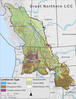 The Great Basin (GBLCC) takes the rest, covering southern Idaho as well as parts of Oregon, Nevada, Utah, and even into California. As they see it, there are no jurisdictional boundaries between states because wildlife doesn't live within boundaries. And wildlife overrules humans. 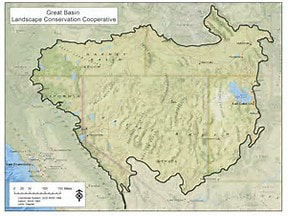 Aside from federal agencies colluding between themselves, they have given power to initiatives such as the Heart of the Rockies (HOTR), Yellowstone to Yukon (Y2Y), and High Divide (HD) to do the work for them. All of them are connected to UN NGOs such as The Nature Conservancy (TNC) and International Union For Conservation Of Nature (IUCN). The map below shows the targeted areas in central and north Idaho by the HD and Cabinet-Purcell Mountain Corridor (CPMC), a Y2Y initiative. IP sits in the High Divide Focal Area. 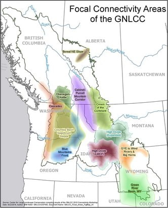 In north Idaho the GNLCC is focusing on connectivity in the Clearwater area using the 2012 Forest Service Planning Rule. The Cabinet-Purcell Mountain Corridor (CPMC) will be used as a transboundary link connecting wildlife between British Columbia and Idaho. Y2Y has formed a collaborative conservation framework for the CPMC region and together they want wildlife to move freely across all jurisdictional boundaries. These folks don't accept the concept of sovereignty and are working aggressively to "secure private lands". Here is the amount of land being pursued in northern Idaho. But the GNLCC doesn't limit it to wildlife, it also includes "ecological connectivity". Ecological captures everything. 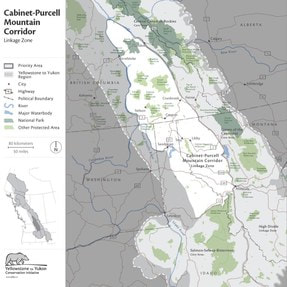 The GBLCC seems to like working with everyone except Idaho, including California, Arizona, Texas, and others. Working with all of these folks, not you, the GBLCC created a Science and Traditional Ecological Knowledge Strategic Plan (S-TEK). Priority topics include adaptation to changes in water availability and ecosystem structure and function. Basically this plan prepares them in deciding what they are going to do to those who live in southern Idaho, and you can bet your booties that it includes land conservation, including wetlands and riparian areas. For the cattle ranchers, look out. The grand plan for you is figuring out how grazing affects sage-grouse, the effects of spring grazing, and the pièces de résistance is possibly halting all grazing for four years just to see what happens.
The Idaho Cattle Association expressed some consternation about the federal land management agencies' plans to manage sage grouse habitat. Along with the removal of junipers this has been the plan all along. Hmm, let's see what will happen if we damage the land by changing it, and when it becomes damaged, then we can justify restoring it. Of course, after restoring it then it must be protected and conserved so it won't be damaged again. Scientific management is the excuse being used to control land use because technocrats don't think anyone else knows how except them. Why, the GBLCC even has their hands in connectivity, including for the pygmy rabbit. This story goes far beyond what has been written. Just understand, these LCCs have nothing better to do than create ways in which to justify taking over land for environmental and wildlife purposes, pushing Idahoans out while banning access or use, dictating how the land can be used, all in order to conserve it for people who have not even been born. There is no federal law that gives any one of these groups authority to do what they are doing but these same vicious groups are actively lobbying for such laws, and are already deeply embedded with Idaho agencies. They are not American in their thinking, they don't believe in how our Republic was designed to operate, they only believe in their own ideology. Wake up Idaho, all of you. This covert agenda will eventually win if action is not taken to oppose it. One cannot escape the fact that NGOs, landscape initiatives, and other individuals are embedded with federal government agencies such as the US Forest Service (USFS) and Bureau of Land Management (BLM). These groups also have powerful lobbying within both the state and federal government with large amounts of money backing their efforts. Their voice has succeeded in overpowering citizen's voices.
Over the last several years these same groups have been studying the State Wildlife Action Plans (SWAP). The SWAP was created by each state and although they vary in focus the primary objective is identifying species and habitat of greatest conservation need (SGCN), threats to them, and proposing conservation plans that will be monitored for effectiveness. SWAP is seen as a "living" document that can be updated and revised at regular intervals depending on how the plan is working. These groups are scrutinizing those objectives to intervene during revisions. In 2012, the Department of Environmental Science & Policy, University of California, literally scoured 49 SWAP plans in the U.S., evaluating the language and content for keywords such as wildlife or habitat connectivity and linkage, and possible references towards incorporating these concepts into large-scale conservation plans. Corridors and movement were two other keywords that were counted. These groups see the SWAP as nothing more than an opportunity for a single framework, a national data set that evaluates and compares conservation planning efforts with no jurisdictional lines between or within states, only conformity with standards they want so desperately to define and control. Idaho would no longer be creating standards for Idaho, or standards that Idahoans want. Because some SWAP plans omitted this type of language it was seen as a hindrance to "...coordinated nationwide planning...". Eleven plans succeeded in meeting their criteria for what they consider best practices. This study was done for the purpose of identifying how SWAP plans could be revised to include more language and focus on the goals for connectivity and integration of what they consider are best practices, stating, "...increasing the emphasis on wildlife linkages, using common language, and incorporating these best practices can directly improve subsequent iterations of SWAP...". Since the Idaho SWAP is a "living" document with periodic monitoring for revisions these groups and lobbyists will be ready to make their case for the insertion of connectivity and linkage language into the plan. Since they are already tied into these agencies it shouldn't be very hard to accomplish. The Gary Tabor organization, Landscape Conservation Cooperative Network (LCCN), used the Gulf states SWAP to integrate their agenda, "...working to ensure that they play a foundational role in the GCPO’s Landscape Conservation Design (a.k.a. Conservation Blueprint). To that end the GCPO LCC has invited SWAP leaders to actively participate in the design process..." and "...will help ensure that the work the GCPO LCC does is value-added by integrating States’ plans across administrative boundaries...". The Great Lakes was another target. LCCN is literally drooling over SWAP plans for their pernicious agenda. The Greater Northern Landscape Conservation Cooperative (GNLCC), a federal program that coordinates these groups, also sees SWAP as "The first step towards integrating landscape efforts", along with the Defenders of Wildlife. This is how the game is played, study the prey, find an opening, then manipulate it for advantages in self-serving agendas. Idaho citizens will not have a say in this in spite of their right to representation. But Idaho Statute, Title 36 36-2405(5) states "The governor’s office of species conservation may petition the responsible public agencies to initiate rulemaking to facilitate the implementation of the approved management plan." and (7) "Nothing in this act shall be interpreted as granting the department of fish and game with new or additional authority." Since Governor Otter is part of the Western Governors' Association (WGA) that partners with the federal government for this conservation agenda, it is highly unlikely rulemaking will be requested. Citizen input for SWAP was not pursued aggressively as with scientists, NGOs, and other outside groups. A public hearing was held in Boise in January, 2016, a Wednesday and Thursday, when people are working, in the dead of winter. Idaho citizens should have first priority for input with these other groups taking a subordinate role. Per Idaho statute there is no authority to enforce SWAP and in spite of getting connectivity or linkage language into the SWAP there is no authority to force it on Idaho citizens. Individuals employed by NGOs and other initiatives work full time implementing their agenda while Idahoans work to earn a living, making it very difficult to find the time needed to oppose this agenda. But it must be done, now. Technocracy is "a system of governance where decision-makers are selected on the basis of technological knowledge. Scientists, engineers, technologists, or experts in any field, would compose the governing body, instead of elected representatives." The right to representation is removed from citizens while these "experts", also known as technocrats, believe they possess impeccable scientific knowledge and are therefore masters of all solutions. Land issues are the perfect example to describe technocracy implementation. Data gathering is the essence of technocracy, examining everything at a microscopic level, so miniscule that the broader picture is obscured. Technocrats believe every species, plant, speck of dirt, drop of water, and human on land needs detailed examination for ultimate management. This is all based on the irrational fear that humans will overpopulate, necessitating the conservation of land for humans that don't even exist. But the truth is, land is rich with resources needed for life. Because technocrats believe land and its resources will be consumed by too many humans, then both must be conserved and controlled, now. That is the deception. Once the data is collected, it will be used for the goal of controlling and managing all resources, and humans. Created in 2005 by the Idaho Department of Fish and Game (IDFG), the Comprehensive Wildlife Conservation Strategy (CWCS) was just for this purpose, bringing together a group of various technocrats for gathering data on species and habitat which might need conservation. Idaho was broken into fourteen "ecological sections", transcending all jurisdictional boundaries, with the next ten years spent on inventorying fish, wildlife, plants, and habitats, mapping their locations with geographic information system (GIS) layers for analysis. Scientific names were added to traditional names for wildlife and plants. A deer can no longer stand on its own as a beautiful creature, it has to be detailed as to type, what it eats, and where it lives. In ten years, with all this data stockpiled, what was a strategy now became a plan, the 2015 State Wildlife Action Plan (SWAP). While this discussion focuses on Idaho, the federal government funded SWAP plans in every state, and the agenda is the same. The list of technocratic "experts" was expanded for this plan. From the CWCS, 205 Species of Greatest Conservation Need (SGCN) were identified, along with their habitat, ecology, and threat information. Not being detailed enough these species were then placed into "tiers" with ranking for conservation need. Going further, species were detailed in each ecological section. For good measure, all vertebrates and invertebrates in the state were inventoried. The more details the better. This resulted in a 411 page document that describes in excruciating detail the species description, conservation status, population trend, habitat, threats, needed conservation action, and other laborious data which will be used to justify the need for regulations that will remove the threat, justifying continued need for conservation. IDFG will need to implement a monitoring system for any changes in this data and that includes more GIS data layers. Needing further detail, the effectiveness of the monitoring will need to be monitored. Adaptive management is used by technocrats to incorporate new information for managing species and habitats. Using "conceptual models", technocrats try to predict desired outcomes for different approaches in conservation to determine if a desired outcome is achieved. In other words, experimenting around with nature. 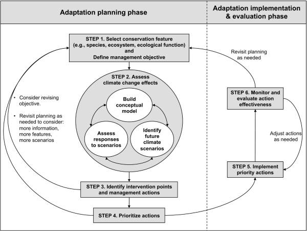 If any of these species or habitat are identified on private property, what will IDFG do? They will have to protect both by regulating your land. Will technocrats have that authority? Because of their power within government agencies technocrats are the likely ones that will make the regulatory decisions. 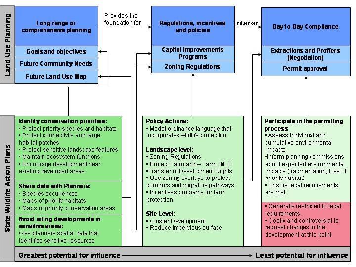 The graphic tells the truth, how microscopic data will lead to regulations that will control how land is used, "influencing day to day compliance", requiring "permit approval", all for the purpose of controlling humans.
Technocracy is the non-violent weapon being used to wage war on America, its citizens, and our system of government. As more data is gathered this weapon will become more powerful in its governance over our lives. There will be no end to it unless citizens exercise their Constitutional right to representation over technocratic agendas. This is the first of a six part series. The reader is highly encouraged to go to these websites and study what is discussed in these articles in order to make an informed decision.
The Island Park area is targeted by an aggressive agenda that could potentially destroy what we have always known and loved. To fully understand this agenda it is important to understand its history. In 2001, the U. S. Congress appropriated federal funds to states for wildlife and fish conservation along with the responsibility to develop a comprehensive wildlife conservation strategy. These strategies were intended to lay the foundation for "a coordinated vision and mechanism to enact conservation at a landscape level". Because this statement was so benign it was difficult for local residents or elected officials to understand its true meaning. In 2005, the Idaho Department of Fish and Game (IDFG) finished the required Comprehensive Wildlife Conservation Strategy (CWCS). The intent was to pass on "our ecological heritage to future generations", and engage others towards this endeavor. The purpose of this strategy was to identify species of greatest conservation need (SGCN) and habitats for conservation, use legal instruments for conservation methods, and involve the public. "Ecosystem management" was also included. Seen as a "living document", open to ongoing revisions, the strategy also recognized "the need for increased and permanent federal conservation funding...". Participants in the CWCS included multiple government agencies and NGOs. The Wilderness Society (WS), The Nature Conservancy (TNC), Defenders of Wildlife, NatureServ (a partner of the program IUCN), and the Idaho Conservation League (ICL) which attaches itself to the Wilderness Society were all actively involved in the CWCS. Local Island Park working groups and elected representatives were not asked to participate as the strategy had intended. "Coordination" took place between federal and state government agencies, other states, land trusts, and even Canada with consultation on regional plans. But Idaho citizens were not included. Idaho was broken up into "eco sections", especially because of its "close association to TNC's ecoregional plans". This was just the beginning of blurring state, county, and private land jurisdictional boundaries. America's foundation is state sovereignty and local control through elected representation, which are are being erased. IDFG also declared, "All wildlife...within the state of Idaho, is hereby declared to be the property of the state of Idaho", to be "...preserved, protected, perpetuated, and managed.” The CWCS states it "does not require any person or entity to implement conservation actions", or "dictate how conservation actions should be implemented", but only to "provide information and general direction...in developing conservation plans" with the development of those conservation plans as "discretionary". In the strategy, species were inventoried, especially the SGCN, habitats for protection were prioritized, and a goal to prevent the spread of invasive species. Although IDFG declared itself as "...not a major land management agency..." it did include partnerships with land management agencies (land trusts groups), plans to "acquire interest in property", assisting private land owners in conservation practices, and reducing impacts from land development. The CWCS laid the foundation to gather data. This data was needed to later justify the creation of large conservation landscapes, and create wildlife and habitat corridors for connectivity. Partnering with NGOs, and with the CWCS, IDFG supported the Heart of the Rockies, Crown of the Continent, Greater Yellowstone, Yellowstone to Yukon, and the High Divide agendas, which all work to place land and species under conservation status, create corridors, and promote connectivity. Island Park narrowly escaped designation as a national monument. But conservation easements, corridors, and connectivity achieve the same result, loss of private land ownership and land use by Idahoans. In Idaho, the goal of these groups are connecting landscape from Yellowstone, across public and private land, over the Continental Divide, and into the Centennials. IDFG is putting policies into place that will help them achieve these goals. A Monitoring Oversight Team, which included the TNC, was formed to coordinate and monitor the implementation of the strategy. Its primary purpose was to develop an overall strategy, identify needs, and set priorities. The CWCS was seen as a "living document", open to any changes necessary. A review of the CWCS in 2010 included revision of the SGCN conservation status, identifying any actions needing modification, and strategy revisions. Recommended actions included encouraging conservation plans with farmers/ranchers, adjusting grazing schedules, reducing residential development, restricting OHV use, allowing naturally occurring fires to burn, identifying linkage zones that provide connectivity between habitats for wide-ranging species along roads and highways, locating and designing highways and roads to reduce and mitigate impacts to wildlife and key habitats, providing corridors of intact, minimally disturbed habitat for wide–ranging species, reducing development on lakes, and designing travel corridors. Establishing corridors for eventual connectivity were the true goals in the CWCS. At the 10 year revision of the the CWCS in 2015, with all that data gathered, we now have the State Wildlife Action Plan (SWAP). What was a strategy has now become the plan. SWAP will implement the creation of corridors beginning with the Hwy 20 Corridor plan, altering the IP landscape with artificial wildlife bridges and fences that wildlife will be forced to use in their migratory path. Elk were not identified in CWCS as a SGCN, but are now the species being used to justify the need for a corridor because of wildlife-vehicle-collisions (WVC). Highways and roads are the arteries that connect people to their land, the majority of which have been responsible in safely accommodating animals during migration across the roads. Attempts to environmentally engineer wildlife is very concerning. But the truth is, the creation of these corridors along highways and roads are stepping stones towards connectivity of large landscape areas. That was the real intent of the CWCS and now SWAP. As a neighbor to Yellowstone Park, Island Park has been, is, and will continue to be a targeted area for conservation by NGOs. They have a renewed and aggressive goal to convince private landowners to place their land into a conservation easements with partnering land trusts included in the CWCS. The agenda will not stop with wildlife. Part 2 will explain how biodiversity, ecosystems, and wetlands are used as justification to create corridors of connectivity. This is the second of a six part series. The reader is highly encouraged to go to these websites and study what is discussed in these articles in order to make an informed decision. Coined in 1935, ecosystem is defined as "a system, or a group of interconnected elements, formed by the interaction of a community of organisms with their environment." Ecosystems have different components of growing, living species. One component is biodiversity. It is defined as "diversity among and within plant and animal species in an environment." Island Park has a multitude of different species which we all love such as wild strawberries, morels, watercress, trees, rainbows, brookies, skunks, porcupines, and the beloved moose and elk. From all indications, each continues to survive in Island Park. Wetlands are "land that has a wet and spongy soil, as a marsh, swamp, or bog." Island Park has the most beautiful marsh behind Elk Creek. In spite of weekly horseback riding through that marsh there was no long term damage. The marsh still exists. Riparian refers to the bank of a river or lake and anything living around it such as fish, other water species, and vegetation. Elk and other animal species use it for water and food. We use it to cast a fly for fish that might take a bite or jumping in for a swim, or maybe just look for a pretty rock. Wildlife, biodiversity, wetlands, and riparian areas are just a few ecosystem components. They are interconnected, dependent on each other for survival, and terms used by NGOs and government agencies to justify their work. Humans are one component not always mentioned. Not seen as a necessary presence in the ecosystem, humans are more often than not considered a destructive force, requiring removal for ecosystem protection. Conservation and removing all human activity are scientists and NGO goals. There is grave concern that land development is encroaching upon buffer zones, areas that surround a protected area which are intended to shield the core area from man’s activities, thus allowing more space for mammals. Private land ownership is in a precarious position. There are ongoing discussions about controlling land use planning from regional to municipal levels. Seen as part of "ecosystem management", land use planning objectives include conservation, stopping development, zoning and growth controls, and increasing restrictions. How you design your home and land will be dictated to you. This article by ScienceDirect explains it beautifully. Land, plant, and animal species don't understand boundaries, extending themselves across states, into designated parks such as West Yellowstone, and even across countries. Ecosystems are viewed in the same manner, there are no jurisdictional boundaries. NGOs such as The Nature Conservancy (TNC), believe these ecosystems, components and corridors, have the right to protection regardless of jurisdictional boundaries. These boundary erasures create a regional concept, erasing boundaries between states and counties, the United States and other countries, and create an artificial "conservation boundary". Essentially, the United States is being divided up into regions with artificial boundaries made up of different conservation areas. Here is a map of "conservation planning boundaries" from the Wildlands Network, which includes the current agenda in Island Park, Yellowstone to Yukon and Crown of the Continent. 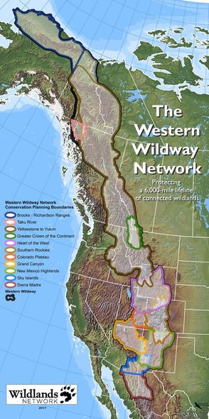 Part of the proposed US 20 IP Corridor Plan is the placement of artificial overpasses for safer passage during Elk migration, just a first step towards creating artificial corridors for connectivity. Each ecosystem component will be gradually introduced for protection, such as riparian areas. Riparian areas extend into surrounding wetlands and other water sources which will extend boundaries further for conservation. Ecosystem components will eventually be used to place the whole environment into some type of corridor needing protection, either through conservation or designation as a protected site. Remember, your private property will be impacted by this.
All of this falls under the Climate change umbrella. According to NGOs drastic action must be taken to not only conserve areas and protect them from humans, "mitigation" measures must be undertaken to prevent loss from development and climate change. The essence of mitigation is to avoid, minimize, and offset environmental impacts to lands and waters. In 2016 the US Fish and Wildlife Service released their new Mitigation Policy. This policy provides a framework and landscape-scale approach for mitigation with increasing conservation, no net loss of resources or values, and effective linkage for landscape scale conservation strategies. Created by the United Nations Environment Program (UNEP), the International Panel on Climate Change (IPCC) always uses science endorsing climate change. However, there is science that does not support the idea of climate change, or even if it exists. According to the International Climate Science Coalition (ICSC) there are opposing scientific views. Even the former Director of Greenpeace, Dr. Patrick Moore, now has doubts. As ecological engineers, scientists believe in giving "point value" to everything, a mathematical formula. Although the NGO conservation agenda has not yet advanced to creating corridors for other components, the same value points will be assigned to them. An example of this can be found in the Cramer Safety Solutions report used in the US 20 IP Corridor Plan, starting on page 159. For some reason land ownership and recreation receive low point value. The environment is remarkably skilled at regenerating itself. Our only job is using it and helping it when needed, like cleaning up the floor bed to reduce fuel loads. It is interesting that such a dichotomy exists with NGOs. On one hand their agenda is leaving the environment in its natural state. At the same time they are creating environmental engineering schemes to alter it. This is a systematic agenda to alter where and how we live, and erase sovereign boundaries. It is part of a broader agenda to destroy state sovereignty and our foundation of government upon which America was built. To all those NGOs and scientists, we have been, and still are, the custodian, guardian, and protector of Idaho and her gifts, way before you were born or formed into little special interest groups, this was not invented by you, and we care for it more responsibly. There has been no long term damage to Idaho from those who have lived here for generations, there is nothing broke that needs fixed. The most comprehensive and destructive land polices were only born when NGOs became involved. Ask any rancher or farmer, they know. The true agenda is pushing us off our land into cities, taking control of our resources, and dictating how, if at all, we can use what is rightfully ours. Idaho is our heritage, our ancestry, we are a native and indigenous people, and we will defend her. There is no bond between you and Idaho. Part 3 will discuss corridors. This is the third of a six part series. The reader is strongly urged to visit these websites and study what is discussed in these articles in order to make an informed decision. Part one covered data collection in the Comprehensive Wildlife Conservation Strategy (CWCS) which was used to create the State Wildlife Action Plan (SWAP) for species and habitat protection. In part two ecosystems and its components were covered These topics create the foundation for corridors and connectivity. Varying greatly in size, shape, and composition, corridors can be described as routes or land tracts used by migrating animals, land designated for specific purpose such as highways like the US 20 Corridor, or they connect "fragmented" patches of habitat. Corridors are seen as a way to increase connectivity, such as transportation or between patches of fragmentation supposedly caused by humans due to different types of land development. Scientists often call this the "anthropogenic" effect, meaning fragmentation is the result of human influence on nature, which NGOs and scientists describe as disruption and "barriers" for plants and animals to survive. They believe corridors, especially protected corridors, provide an unbroken path of suitable habitat and safe passage, if it weren't for humans disrupting it, and connectivity. Three types of corridors follow. Biodiversity corridors are areas of vegetation that allow animals to travel from one patch to another, providing shelter and food for different species. Blaming anthropegenic activity, scientists believe that all species become isolated and unable to migrate as intended because of human "barriers". Elk don't care if they cross your property to get where they are going, they and other grand creatures do it all the time. The agenda underway is identifying biodiversity corridors for conservation to restrict or mandate a full ban on all "anthropogenic" activity, thus ensuring species movement between patches, which already exists now. Island Park residents know differently, we have co-existed with all animal species and their movement from before the time of my father. Wildlife corridors are tracts of land allowing wildlife to migrate for food, shelter, and mating between habitats with migratory paths as an example. Wildlife use biodiversity corridors during their journey for necessary food and shelter. Elk, moose, and other migratory species in Island Park have migrated along these paths for centuries. Who in Island Park has not watched them on their land as they move through? Riparian corridors have everything to do with water. This includes wetlands, marshes, ponds, streams, creeks, springs and lakes. Water species such as fish and beavers, and plants that thrive in wet environments are all included in these corridors. These corridors naturally intersect with biodiversity and wildlife corridors and are often extended by scientists to include buffers, zones, and land for restricted use. Everything is connected to water. However, scientists believe anthropogentic activity is destroying natural corridors and corridors should be sewn together for connectivity, with no "disruption" or "barriers". NGOs, scientists, and the government want us to believe they have the knowledge and authority to artificially engineer corridors. Sorry, Mother Nature beat you to it, her corridors already exist naturally, scientists are only artificial engineers and will never surpass Mother Nature. It is disheartening to watch scientists attempt to environmentally engineer land and corridors that are already perfect with roads and private land not disrupting migration paths, the paths are still there. In 2008, the Western Governor's Association (WGA) participated in this agenda, signing a memorandum of understanding (MOU) with the DOI, DOE, and Department of Agriculture to "coordinate and identify key wildlife corridors and crucial wildlife habitats for uniform mapping and recommendations on policy options and tools for "preserving those landscapes". Did Governor Otter contact you for your opinion? How about those other governors making decisions for Idaho? While the USDA touts the benefits of corridors, there are also studies that have been conducted on the detrimental effects. Because species are crowded into a artificially designed landscape it is often an invitation for invasive species, whether plant or animal, and increased predator behavior. There is also the belief that fragmentation lowers genetic diversity if one herd can't get to another. Elk have been moved around to different locations by scientists for experimentation on their genetic diversity and divergence (mutation). What impact does this have on Elk and the natural order of the environment which is subject to natural laws, not human? Another aspect to corridors is conservation easements. According to the Kansas Natural Resource Coalition, "Often CE properties are enrolled into programs for introduction of endangered species or development of ‘corridors,’ a initiative itself that can profoundly affect communities, industry and private lands. The introduction of endangered species substantially impacts the productivity of neighboring properties." This is the intention of SWAP, identifying species of greatest concern and habitats needing protection. Something to keep in mind if you are asked about placing your land into a conservation easement. Your property may have already been identified for conservation "value" which might contribute to an effort for corridor conservation. These corridors, and all their components, lie within an ecological boundary known as an ecosystem. Ecosystem can be defined as "a system, or a group of interconnected elements, formed by the interaction of a community of organisms with their environment." Scientists have included Island Park in the Greater Yellowstone Ecosystem (GYE). The GYE boundaries are shown in this map. 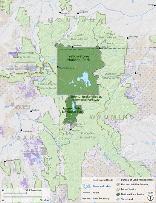 The American Wildlands "Corridors for Life" program from 2007, Center for Large Landscape Conservation (CLLC), Defenders of Wildlife, Wildlife Conservation Society (WCS) with whom the new road ecologist Renee Seidler is connected, and the USFS focus on creating wildlife corridors for connectivity while the North Pacific LCC, Washington State University, and GNLCC focus on riparian connectivity. Using corridors for connectivity is published in their agendas. The scientists who conducted studies in Island Park even admit that wildlife overpasses are needed for connectivity but have not disclosed that to the public. Island Park residents are provided only information about wildlife vehicle collisions to justify the need for wildlife overpasses while the bigger threat, changing the environmental structure, culture, identity, ownership, and heritage of Island Park, is omitted.
Gary Tabor, founder of the Center for Large Landscape Conservation (CLLC) and who mingles with all the local initiatives, worked with Va. Rep Donald Beyer (D) on H.R. 6448 (114th): Wildlife Corridors Conservation Act. Although not enacted in 2016, there are plans to reintroduce it again this year. This bill would create a "National Wildlife Corridors System" which would mean federal law for corridor designation, much like a national monument designation. Island Park residents don't want to be a federally designated anything. Also not welcome, a Virginia representative making decisions that would potentially affect Island Park. The new ITD "road ecologist", Renee Seidler, participated in a migratory study on Pronghorn in Wyoming. While the WCS claims the "U.S. Forest Service established the nation’s first federally designated wildlife corridor" in 2008, the truth is somewhat different. It was not a declaration of the "first" federally designated corridor, it was a forest plan amendment that merely allowed "continued successful pronghorn migration." Amending the "...Bridger-Teton National Forest Land and Resource Management Plan by designating a Pronghorn Migration Corridor...", it added the following standard, “All projects, activities, and infrastructure authorized in the designated Pronghorn Migration Corridor will be designed, timed and/or located to allow continued successful migration of the pronghorn...", while not constraining "...activities on private land..." within the forest boundary. The report also states, "...activities currently authorized by the Forest Service within the corridor coexist with successful migration..." such as grazing, and concluded that no changes were needed for grazing or infrastructure. So, the Bridger-Teton National Forest Supervisor, in a NEPA Environmental Assessment phase, casually gave a name to a section of forestland that already existed, the NGOs then exaggerating it into some grand event which didn't exist. There was no congressional act or official designation, no state declaration, no proclamation, nothing. The BLM is not part of this forest plan amendment. "The amendment just signed does not protect the entire pronghorn migration - it applies only to 45 miles of the migration corridor located on Forest Service lands. The remaining 30 miles of the migration route occur on private lands and areas managed by the Bureau of Land Management, BLM." Seasonal protection of the Pronghorn is provided by the BLM but there is no federally designated Pronghorn corridor as the NGOs would have us believe. Now this exaggerated claim has been stretched to declaring the "Path of the Pronghorn" as the "only federally-designated wildlife migration corridor in the United States". It is misleading and dishonest. Beware, the WCS is watching Craters of the Moon stating Pronghorn are "...restricted by mountains, fences, a highway, and fields of jagged lava from Craters of the Moon National Monument and Preserve...”. How do those Pronghorn migrate every year in spite of these restrictions and natural landscapes? Using the Elk migratory path is just the first step, next will be a demand to protect the biodiversity corridor, then a riparian corridor, any corridor will be used to continue sewing them together for control over the land while describing it as connectivity, and for a "seamless" integration into the GYE. They don't care about the Elk, they are only interested in using them to take land for their agenda. Island Park residents have "connectivity" with their land as those before him, crossing different "corridors" that allow us to remain "connected" to our land. There is no justification for taking what already is a blended and pristine area, breaking it into ecological categories and corridors, violating state and county sovereignty, then creating plans to alter it. This misrepresents the reality that Island Park is already connected, in every way. The only disconnection is the one that is fabricated by scientists, NGOs, and the government. It is their imaginary utopia being imposed on Island Park residents, and those poor Elk. The greater plan by scientists and NGOs is putting Island Park into full conservation status without your consent, creating artificial landscape designs and boundaries, convincing you that corridors aren't connected because a road or your house is in the way, telling you connectivity is needed for integration into an ecosystem where it already exists, and destroying our God given right and legal authority as Fremont County residents to control how land is used. From the Declaration of Independence: It becomes necessary for one people to assume: "...the separate and equal station to which the laws of Nature and of Nature's God entitle them..." "...that they are endowed by their Creator with certain unalienable rights, governments...deriving their just powers from the consent of the governed...". The consent of the governed has not been given for these plans. Part 4 in this series will discuss connectivity, who is involved, and its implications. Connectivity This is the fourth of a six part series. The reader is strongly urged to visit these websites and study what is discussed in these articles in order to make an informed decision. Part one covered data collection in the Comprehensive Wildlife Conservation Strategy (CWCS) which was used to create the State Wildlife Action Plan (SWAP) for species and habitat protection. In part two ecosystems and its components were covered and corridors were explained in part three. Now it is time to put all of it together with connectivity, the true agenda. Here is the map of the boundaries in the Greater Yellowstone Ecosystem (GYE), where the corridors and components lay. 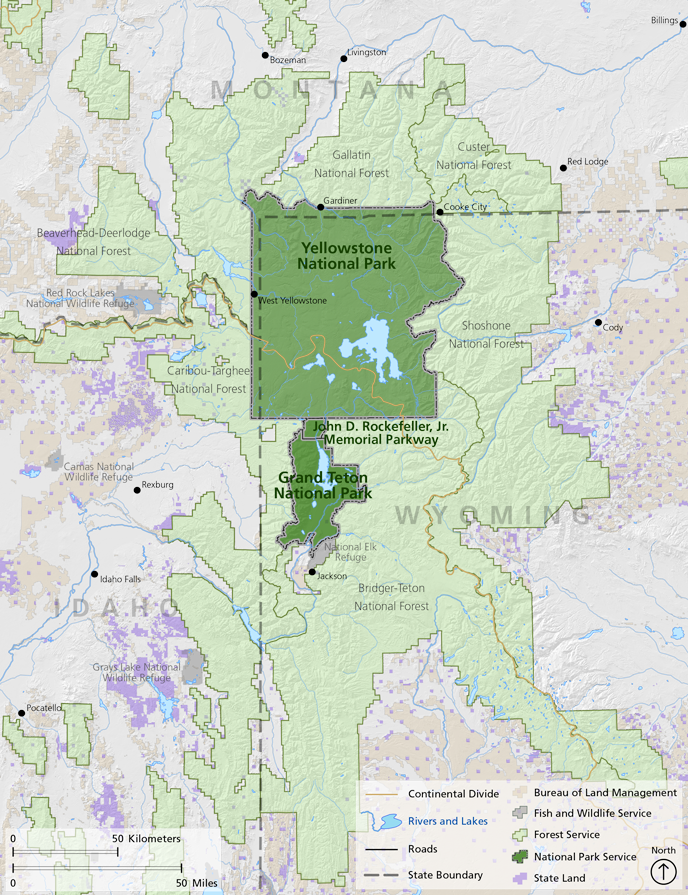 Keeping corridors within the ecosystem boundary is the foundation for connectivity with Island Park as a prime target in the GYE. NGOs and scientists are using the US 20 Corridor and Elk migration to advance connectivity at Targhee Pass. It has nothing to do with saving Elk, the Elk are being used for emotional manipulation and a distraction. Several targeted areas for redesign have now been narrowed down to just the Targhee Pass, only because it is the closest site for connectivity. With the Strategic Wildlife Action Plan (SWAP) identification of Species of Greatest Conservation Need (SGCN) and priority habitat conservation, along with other corridors, the plan has been established for sequential, consecutive, and progressive steps towards connectivity in the GYE, giving wildlife "room to roam". Island Park has a yellow star for high connectivity, this connectivity plan has been in the works for several years, and that is why IP is being targeted. 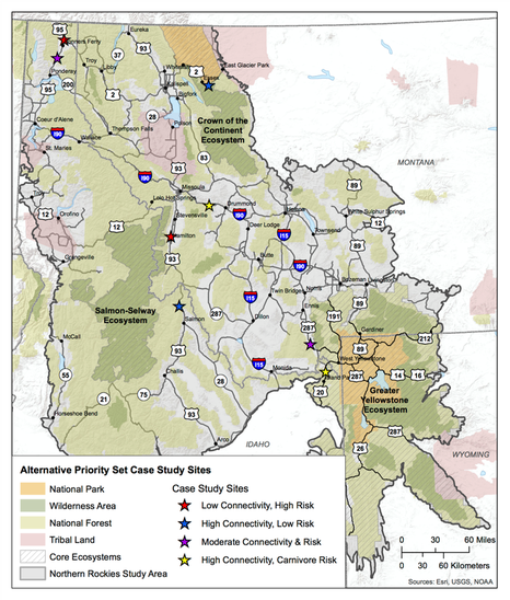 Scientists and NGOs believe connectivity is needed for species population persistence, ensuring that one or many species can move freely throughout the landscape. Because they also believe humans cause connectivity "fragmentation" with land development, a highly aggressive effort is underway to convince land owners to place their land into conservation easements (CE), restrict or ban road use, restrict development and growth boundaries, buy land, and take advantage of road corridors for halting fragmentation. To these groups, connectivity means highly restricted human use to none at all. Corridors and connectivity are the means to control land use. Once land is in their possession, regardless of being a CE, protected or restricted area, or any other designation, control of that land will be dictated by the government, NGOs, and land trust groups. If your county elected officials allow it, these groups will try and convince them to change land use planning in comprehensive plans, forcing you to comply with conservation measures on your property, reduce land use, and dictate or halt how you use your land. The Wildlife Conservation Society (WCS) has already "provided site-specific science in this region to aid Fremont County, Idaho to prepare a comprehensive growth and subdivision plan that considers the importance of protecting biodiversity and wildlife migration corridors." The Northwest Property Owners Alliance (NWPOA) in northern Idaho has already been through it and can tell you what will happen if your county acquiesces. They experienced the same dynamics being used by the US 20 Corridor study team including failure to notify, misinformation, and domination by special interest groups. Their article on environmentalism really captures what Island Park is experiencing. In 2015, after two years of steering committee meetings (including UN NGOs and Canada), the Greater Northern Landscape Cooperative (GNLCC) released a preliminary "Connectivity Pilot Project" report and "...selected connectivity as a priority shared landscape objective...". The second of four objectives was to, "Conserve a permeable landscape with connectivity across aquatic and terrestrial ecosystems, including species movement, genetic connectivity, migration, dispersal, life history, and biophysical processes." The corridors discussed in part three, plus the others listed here will all be used to justify placing Island Park into a massive, large scale, conservation area and eventual integration into the GYE as a protected area, under complete conservation status, with controlled land use. This agenda has been in the works for years, using Elk and the US 20 corridor is just the first step. Their "data basin" is used to "inventory connectivity data"..."identify important areas for action"..."identify potential connectivity opportunities"...with the data also capturing..."'human footprint’ layers"..."land use stressors that may be expected to impact connectivity"..."as well as map layers representing jurisdictional boundaries." Island Park is specifically targeted in this report. Using the High Divide (HD) as their "connection", the short term objective included mitigating US 20 and Hwy 87 corridors and habitat augmentation at highway crossings. Long term objectives included annexing Henry's Fork and Island Park from the Great Basin Landscape Conservation Cooperative (GBLCC) to GNLCC; supporting collaborative work of state and federal agencies, and NGOs to conserve private lands and connect public lands; focusing on landscape water conservation; implementing highway mitigation for key linkages; and creating disincentives for wildlife urban interface (WUI-zone of transition between unoccupied land and human development). Participants in this report included Gary Tabor, Michael Whitfield, Gregg Servheen, and Renee Seidler, the new ITD road ecologist expert for the US 20 Corridor plan. Ms. Seidler has stated her belief in connectivity, her other work is on connectivity, the cooperative agreement between the ITD and IDFG states the job responsibilities included developing programmatic and site specific information and criteria on wildlife connectivity, and her job description states the same. Conveniently, IDFG Wildlife Coordinator, Gregg Servheen, is on the GNLCC Steering Committee mentioned above, and signed the contract between IDFG and ITD for the position Ms. Seidler eventually took through the Wildlife Management Institute (WMI). Mr. Servheen also works on helping you turn your land over for conservation easements (CE) through the Private Landowner Network, or find conservation resources. He worked with the Western Governor's Association (WGA) to build data bases on biological information for preserving wildlife corridors and habitats, and the goal to "complete a connectivity/linkage plan" along the High Divide. While all of this gives the appearance of impropriety, it is nothing more than a self-created, conglomerate of government agencies and NGOs, operating under no legal authority, working without public involvement on plans to address issues they created, disguising it as their concern about wildlife vehicle collisions (WVC), and which will eventually be used as an excuse for wildlife connectivity. WVC are nothing more than a distraction to keep you from learning about the connectivity agenda. A copy of the contract can be downloaded here.
In fact, the ITD and IDFG were so confident the US 20 Corridor project was in the bag, they hired Ms. Seidler by April 17th to move on to the connectivity phase. This was at least 10 days prior to the cancelled April 27th meeting that was supposed to include Island Park residents and their input.  Ms. Seidler is well prepared for this job having previously conducted a study with IDFG in 2014 called: US 20, Island Park Wildlife Collision Study, An examination of Road Ecology in the Island Park Caldera: Elk and Moose Migration Across US Highway 20. The summary states, "Conservation and mitigation efforts for Elk and Moose...will likely have significant positive impacts on habitat connectivity...". A copy of this report can be downloaded here. The GNLCC held a major workshop in 2015, Conservation of Continental Connectivity through Community Based Collaboration. Presenting at this workshop, the High Divide celebrated their increase in CE from 194,483 acres to 1.2 million in 9 years, and their work in connecting large core protected areas and wildlife connectivity. Their goal is Ecological linkage between protected core areas to conserve wide-‐ranging wildlife in response to climate change, not WVC. To them, "Working Across Boundaries" includes "Local expertise—stakeholder input". This has rarely been sought from Island Park, but rather from an assembly of scientists, government officials, and NGOs, few who even have one connection to Island Park. The goal is complete "protected" connectivity in large landscape areas where Island Park sits. GNLCC held a Resource Managers Connectivity workshop in April, 2015, with Ms. Seidler as a participant and Gary Tabor and Michael Whitfield as speakers. Mr. Whitfield was also on the program committee for the 2014 National Workshop on Large Landscape Conservation held in Washington, D.C.. Federal government agencies and NGOs comprised 76% of the participants, with only 1% landowners participating. As the founder of the Center for Large Landscape Conservation (CLLC), Gary Tabor has created both a Connectivity Conservation Hub in partnership with the GNLCC, located in Jackson, and a Ecological Connectivity Project with all the data and maps needed to conserve "a permable (sic) landscape with connectivity across its geography". According to Mr. Tabor, "A corridor is a distinct component of the landscape that provides connectivity. Wildlife corridors specifically facilitate the movement of animals, while other types of corridors may support connectivity for plants or ecological processes." The Ecological Connectivity Project brings "managers" together who focus on connectivity. "The goal of the project is to conserve a permeable landscape with connectivity across aquatic and terrestrial ecosystems, including species movement, genetic connectivity, migration, dispersal, life history, and biophysical processes." Michael Whitfield from the High Divide is also involved. This project does not include any Island Park residents, only government officials, NGOs, and initiative leaders. The justification for this project are primarily based on executive orders, policy resolutions, white papers, secretarial orders, and regulatory decisions that are not found in Idaho or federal law. However, GNLCC funding for 2017 is directed towards supporting this project for water, species, terrestrial and migration connectivity in large landscapes, your tax dollar. 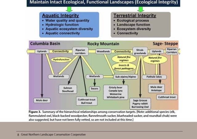 Hidden on a US Geological Survey website is the 2015 proposal, "Landscape Conservation Design in the High Divide" with Mr. Whitfield as the Project Coordinator, and who is also the executive director of the Heart of the Rockies (HOR) initiative. Multiple NGOs, land trusts, and federal and state agencies are involved. The project summary "...seeks support to identify and evaluate future landscape configurations...emphasizing wildlife connectivity between large protected core areas..." such as Yellowstone. The need for "Landscape Conservation Design" was cited as one of the elements of the USFWS Strategic Habitat Conservation Plan. "A conservation design (cluster development) is a type of “Planned Unit Development” in which the underlying zoning and subdivision ordinances are modified to allow buildings (usually residences) to be grouped together on part of the site while permanently protecting the remainder of the site from development." This project supports the GNLCC Strategic Conservation Framework, one goal being to "Conserve a permeable landscape with connectivity across aquatic and terrestrial ecosystems...". All of the data collection will be used to redesign Island Park into some artificial utopian paradise, rather than let her exist as she has for centuries, or be developed through local representation. And with all due respect sir, do not lump residents into a "Human Modification Index. Workshops on this project were supposedly held in Nov 15' through Fed 16', conveniently when most residents were not available. This is how subversive these groups are. A copy of the proposal can be downloaded here. These individuals and groups have been working with each other, making decisions about Island Park and the residents, behind their backs. Do those who live in Island Park want their covert plans?
The following initiatives and organizations are actively involved in the connectivity agenda: Heart of the Rockies (HOR); Yellowstone to Yukon (Y2Y), High Divide (HD), Crown of the Continent (COC), Greater Yellowstone Coalition (GYC), and Future West (FW). "Although America's national parks include some of the wildest places on Earth, no park in the U.S....is large enough to support the full range of native biological diversity over the long-term. In order to accommodate wide-ranging animals...our parks must be connected to other protected areas via wildlife corridors and their boundaries should be expanded wherever possible." (Rewilding Our National Parks) A brief word why so many "experts" are making the decisions. These scientists are actually technocrats, experts in science who have a lot of power in, or influence with the government and are an adherent of technocracy. Technocracy is the power shift from elected representatives and bureaucrats to technocrats (engineers, managers, scientists); management of society by technical experts; or a society that is controlled by scientists, engineers, and other experts. Is this not where we are at? Patrick Wood has a series of excellent videos on his website, Technocracy News and Trends, that provide valuable insight into how our government has transitioned over to these "experts" and away from the people. It is the responsibility of elected officials to listen to those who elected them, not technocrats or special interest groups, or those who are not Fremont county residents. Have we abdicated our inherent power and responsibility of self-governance to others? Or has it been stolen from us? No efforts have been taken to disclose or involve Island Park residents in these plans, no alternatives to overpasses and fencing have been discussed, no input has been sought from anyone except the UN NGOs, cooperatives, technocrats, and government agencies, and No discussion has ever taken place on their plans for connectivity. Studies were conducted for the US 20 Corridor plan without required prior notification to Island Park residents. And why should they bother, the protection of Elk is not the issue, it is a distraction from what they are really planning. All evidence points to the agenda for connectivity, on websites, in reports, participants own statements, and in studies. The ITD, their study team, NGOs, and initiatives have not been transparent with Island Park residents, misrepresented what they are actually doing, and have violated every drop of what is ethical. Shame on all of them. It is important to remember, there is no federal legislation for this agenda. What law allows arbitrary erasure of jurisdictional boundaries? This is a concerted effort by individuals and groups with an ideology, who have successfully engaged the government with the same ideology, and are proceeding forward without any laws. Island Park has a population of 286 as of 2016. That swells to several thousand during the summer when residents come to their summer homes. The number of individuals pursuing this connectivity and conservation agenda are in the thousands, with millions of dollars being funneled into it. Island Park residents, who own homes and pay taxes, are the guardians of Island Park, and who elect city and country officials to represent them. Officials are obligated to listen to their voice, not special interest groups from other states or counties. The technocrats and elite who believe they know better, and who hide their agenda, are usurping those rights. Is this what Fremont County citizens want? The Declaration of Independence states governments derive "...their just powers from the consent of the governed." The Idaho Constitution, Article I, Section 2 states, "All political power is inherent in the people." It is time to recapture the self governance our Founding Fathers created for us. No individual wants Elk harmed and WVC must certainly be addressed. However, tearing up and environmentally engineering the land for ulterior motives is not the solution, there are other alternatives beyond what the technocrats say won't work that require consideration. Island Park residents should be the lead in discussing these alternatives, how they want to protect her and the Elk, and the ones who hold the right to make those decisions. These technocrats and NGOs have zero connection to Island Park, spending their time reducing it to nothing more than a mathematical formula, and assigning point values for the purpose of artificially engineering it into something that it isn't. There is no Island Park asset that has more or less value than another and in spite of what they say or believe, this land is not "fragmented" by us, it is fully connected in every way. They are welcome to visit and walk on the path they designated, but respectfully, do not come to Island Park for environmental engineering, passing it off as a transportation project for saving wildlife when your true goal is connectivity and "conservation design". Island Park is ours to protect, not yours to alter. Part 5 will reveal where all of this originated. This is the fifth of a six part series. The reader is highly encouraged to go to these websites and study what is discussed in these articles in order to make an informed decision. It is critical to understand the massive number of organizations who are involved in this connectivity agenda and who align with government agencies to advance it. In 2010, the Obama administration issued a memorandum, creating the America's Great Outdoors Initiative without any federal legislation, and assigning eight federal agencies to implement it. Two objectives were the creation of "corridors and connectivity", and advancing those "priorities through public private partnerships". A DOI order created 22 large landscape cooperatives across the U.S. with Island Park sitting in the Great Northern Large Landscape Cooperative (GNLCC). These cooperatives were tasked with coordinating all landscape conservation groups, including partnering federal agencies, placing land into conservation, and connecting them into large landscapes. There are 56 landscape initiatives that belong to the GNLCC including Yellowstone to Yukon (Y2Y), High Divide (HD), Crown of the Continent (COC), Heart of the Rockies (HOR), Greater Yellowstone Coalition Committee (GYCC), Western Governors Association (WGA), and multiple land trusts. Here is their Steering Committee.  But there are other large landscape conservation groups as well. Gary Tabor is the founder of the Center for Large Landscape Conservation (CLLC), co-founded the Y2Y Conservation Initiative, the Roundtable of the COC, and co-designed the Western Governors’ Association Wildlife Corridors Initiative. The Conservation Corridor, an International Union for Conservation of Nature (IUCN) program, facilitates wildlife corridor and ecological connectivity conservation, of which Mr. Tabor is the regional leader Vice Chair. As recent as 2016, Mr. Tabor was participating with the IUCN for Areas of Connectivity Conservation. Here is the CLLC network of partners.  The Landscape Conservation Cooperative Network (LCCN), "is the collective of the 22 LCCs collectively", whose council consists of the BLM, USFS, NPS, USFWS, among others; NGOs NatureServe and TNC; four international participants; and the CLLC.
The Network for Landscape Conservation (NLC), was created by the University of Montana and Lincoln Institute for Land Policy (LILP). Their mission is "helping people work effectively across boundaries to...protect...or connect natural systems at the large landscape scale...", and support an "enduring system of protected and connected natural systems at the large landscape scale." Gary Tabor and Michael Whitfield are on the coordinating committee. The LILP has a Large Landscape Conservation Strategic Framework for Policy and Action. The WGA plans to launch a pilot project for wildlife mapping, identifying areas where development can occur with minimal impacts to wildlife, with Island Park being one project areas. Phase 1 includes inventorying species, habitat, unfragmented landscapes, protected habitats, and geographic features while evaluating connectivity tools and models in cooperation with NatureServe and WCS ongoing efforts to formulate connectivity best management practices. The project promises to contact all relevant stakeholders within the pilot area at the initiation of the project, including but not be limited to: Y2Y, WCS, and TNC. The project intends to hold at least 2 "stakeholder" meetings, with Island Park being one of those communities. By the end of Phase 1 they plan on having a "Completed connectivity/linkage plan identifying steps, tools, and outcomes for producing a connectivity data layer for the entire ID‐MT divide project area." The NGOs and HD must be thrilled. No start date was listed. The Brainerd Foundation funds the NGOs Earthjustice, TNC, SC, WS, and NWF; COC, GYC, Y2Y, FW, and HOR initiatives; the Henry's Fork Foundation and Sonoran Institute. The Sonoran Institute partners with the TNC, WS, BLM, USFWS, NPS, and the Bureau of Reclamation. The Wilburforce Foundation (WCS partner) funds Y2Y, and the Turner foundation also funds these agendas. As one can see, there are a substantial number of groups involved in this connectivity agenda, as well as money pouring in from wealthy individuals with the same ideology, and your tax dollar. But where are the voices whose heritage is bonded and connected to Island Park? Their voice, with first rights in importance, has been left out. The US 20 Corridor has a website specific to the Targhee Pass Environmental Assessment (EA) phase of the project. It states ITD, following National Environmental Policy Act (NEPA) requirements, is initiating an EA to evaluate risks, benefits, opportunities and costs associated with reconstruction of Targhee Pass, with the Federal Highway Administration (FHWA) as the lead agency. ITD has been studying the US 20 transportation corridor for 13 years, working with IDFG and the Henry's Fork Legacy Project (HFLP), assessing its condition, and identifying necessary improvements. Three studies were conducted during that time. 2014 (Cramer) - Methodology for Prioritizing Appropriate Mitigation Actions to Reduce Wildlife-Vehicle Collisions on Idaho Highways; 2014 (Seidler) - US 20 Island Park Wildlife Collision Study - an examination of Road Ecology in the Island Park Caldera: Elk and Moose migration across US Highway 20 - Final Report; and 2016 (Cramer) - Safety Solutions for Wildlife Vehicle Collisions on Idaho’s US 20 and SH 87. Technocrats and individuals from outside the area have the lead voice here. According to the website it was also during this time "one-on-one conversations with local agencies, municipalities, tribes and other key stakeholders" also took place, which were used for the Targhee Pass Environmental Study. ITD states comments on wildlife vehicle collisions (WVC) were "received in the scoping phase" of the study. Aside from the IDFG, HFLP, and technocrats, who? What Tribes? The website states the NEPA process begins when a federal agency develops a proposal to take a major federal action or (as in this case) when federal funds would be utilized to implement a project. Federal funds were approved for this project in October, 2016. So the NEPA process was started prior to the funding? What does federal law say? § 23 CFR 771.119 Environmental Assessments, § 771.111 Early coordination, Public involvement, and Project Development, and § 450.210 Interested parties, Public involvement, and Consultation, all require public involvement for transportation planning and actions requiring an EA. This is accomplished through an early coordination process and is incorporated into the EA which should be available for public inspection. One or more public hearings...at a convenient time and place for any...project which requires significant amounts of right-of-way, substantially changes the layout or functions of connecting roadways...or has a substantial adverse impact on abutting property are also part of the law. The state is also required to develop and use a documented public involvement process that provides opportunities for public review and comment at key decision points. What opportunity for involvement were citizens granted during the studies, or even from the beginning 13 years ago? § 23 USC 128: Public Hearings states, "Any State transportation department which submits plans for a Federal-aid highway project involving the by passing of or, going through any city, town, or village, either incorporated or unincorporated, shall certify to the Secretary that it has had public hearings, or has afforded the opportunity for such hearings, and has considered the economic and social effects of such a location, its impact on the environment, and its consistency with the goals and objectives of such urban planning as has been promulgated by the community." The ITD excluded all of this. Were public hearings held regarding proposed actions on the corridor, during a time when all were in residency? The website claims "The first step in the environmental assessment process is called scoping. This is an opportunity for the community to help identify issues and concerns specific to the study corridor." According to their timeline a study initiation and stakeholder assessment occurred in October, 2016. One public meeting was held in December with comments incorporated to refine alternatives and impact assessment methods in January, 2017. The subsequent April meeting was cancelled. The ITD Corridor Planning Guidebook mandates public participation and county official involvement at the beginning of any proposed project. Does it sound like the public and county criteria were met? How could it be the initiation of the project when studies had already been conducted, deals were made with other agencies, and only select groups involved? Community based organizations are also listed as important groups for outreach. Aside from the HFLP, the majority who don't live in Island Park, what other community based organizations were contacted? Island Park residents should give serious consideration to creating a Civic Advisory Committee for transportation decisions, separate from NGOs and select groups, for comprehensive perspectives. More importantly, this project should be started over and conducted according to the law. The ITD has clearly failed in meeting the public involvement requirement during the transportation planning. Open houses were scheduled during months when the majority were not in residence, and when the most difficult winter road conditions existed. A public hearing was never offered during a time when all were in residency. In addition, required socio-economic factors were clearly not included in the proposal or in any of the studies. Is it possible neither the NGOs or the ITD wanted the truth to come out? If this Targhee Pass project moves forward, Island Park better prepare for possible land use planning changes that will follow. As previously mentioned, Northwest Property Owners Association (NWPOA) went through this nightmare but successfully stopped it. Their local NGO attempted to incorporate restrictive regulations into their county comprehensive plan which included: requirements for using qualified design professionals; assessments and studies for professional design and best management practices; zoning restrictions; impact fees; development moratoriums; growth limits; and incorporation of state and/or federal laws. ScienceDirect has an excellent article, Land use planning: A potential force for retaining habitat connectivity in the GYE and Beyond, that is full of the scams taking place now, including the belief that "...counties could exert more power in controlling private land development." Defenders of Wildlife promote using State Wildlife Action Plans to link conservation with land use planning. Both are worth reading to understand future agendas if this connectivity project moves forward. Conclusion in Part 6. |
Archives
May 2023
Categories
All
|
||
 RSS Feed

